Runman292
-
Posts
766 -
Joined
-
Last visited
Content Type
Profiles
Blogs
Forums
American Weather
Media Demo
Store
Gallery
Everything posted by Runman292
-
Got about 2 inches in Oak Ridge. Very happy to see a good amount of mesurable snow IMBY.
-
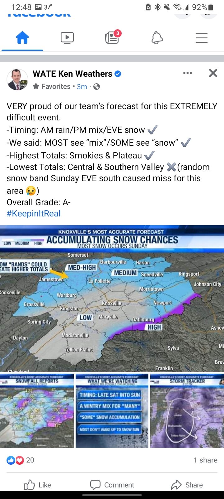
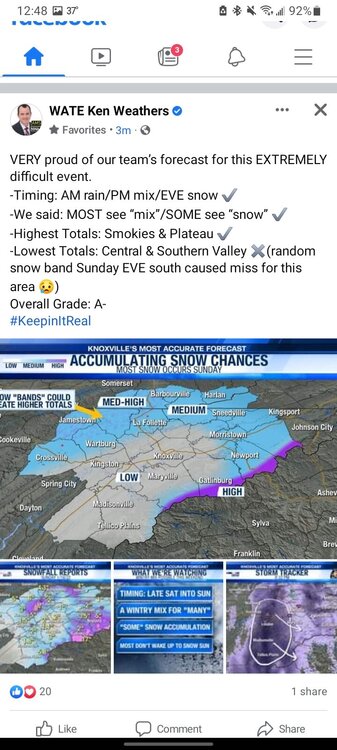
This is hilarious. WATE is giving themelves huge kudos for how they did with the forecast for this system. I definitely didn't think they got an A- when they whiffed big time in the central and southern valley.
-
34 degrees in Oak Ridge.
-
Winter Storm Warning for Anderson County, but i feel that is more for Clinton, Rocky Top, ect than it is for Oak Ridge.
-
Around a foot of snow IMBY?

-
I've met him a few times (when wvlt was doing the weather vols picnics and when i got to tour the wvlt building), and I haven't gotten the impression that he is pompous. Out of all of the local meteorologists, he's been my favorite. Seems to be a bigger fan of snow than the other TV mets.
-
Nickel to quarter size flakes in Oak Ridge to update my last post.
-
I got a question regarding a certain map on pivotal. When is the snowfall depth position change map useful to consider?
-
Just waking up, and no snow to be found in Oak Ridge. I'd say we probably had a light dusting at best that melted quickly. Congrats to others who got to see good snow.
-
I'm heading to bed. Not expecting much here. I hope everyone else scores a good snow.
-
All i've seen is rain with some sleet mixing in for a little bit before turning back to all rain.
-
Rain is still holding on in Oak Ridge. Haven't seen any flakes yet.
-
Sleet is now mixing in with rain in Oak Ridge
-
I can confirm that any blue showing in Oak Ridge is rain so far, at least IMBY.
-
Still rain in Oak Ridge.
-
To add to my other post, the app i use for current temps (captain accurate weather app) says that it is 39° here.
-
I'm about 2 miles west of the Turnpike/Illinois Ave intersection in Oak Ridge, and it's all rain.
-
Seeing pea to penny size hail in Oak Ridge.
-
Interesting that they highlighted Southeast TN in the MD, but didnt include that area in the watch.
-
Mesoscale Discussion 0276 NWS Storm Prediction Center Norman OK 0741 AM CDT Sat Mar 27 2021 Areas affected...Much of middle and eastern Tennessee into parts of southeastern Kentucky and southwestern Virginia Concerning...Severe potential...Watch possible Valid 271241Z - 271445Z Probability of Watch Issuance...40 percent SUMMARY...An evolving cluster of thunderstorms will continue spreading across the Tennessee Valley toward the Cumberland Plateau through 11 AM to Noon EDT, with some potential to organize further and begin producing strong to perhaps occasionally severe wind gusts. It is not yet certain that a severe weather watch will be needed, but trends will continue to be monitored for this possibility. DISCUSSION...Consolidation and upscale growth of vigorous thunderstorm development continues across parts of the Mid South into Tennessee Valley region. This is being supported by large-scale ascent associated with lower/mid tropospheric warm advection, beneath a zone of enhanced divergence aloft, which is forecast to continue spreading across the Tennessee Valley into the Cumberland Plateau through 15-16Z. This convection includes at least one area of increasing organization, with a possible evolving broad mesoscale cyclonic circulation near Nashville. This still appears rooted above at least a shallow near-surface, potentially cool/stable layer, but mid 60s+ F surface dew points have been surging toward the southern Tennessee state border area the past few hours. Although cloud cover appears likely to slow boundary-layer insolation ahead of activity, it is possible that thermal advection and moistening could contribute to increasing boundary-layer instability as far north as the Interstate 40 corridor of eastern Tennessee within the next few hours. If this occurs, a corridor with potential for strong to severe wind gusts could begin to develop by mid to late morning, in the presence of sheared, 30-50+ kt southwesterly to west-southwesterly flow in the 850-500 mb layer.
-
Mesoscale Discussion 0260 NWS Storm Prediction Center Norman OK 0431 PM CDT Thu Mar 25 2021 Areas affected...northern GA...eastern TN...far western NC...extreme upstate SC Concerning...Severe potential...Watch possible Valid 252131Z - 252330Z Probability of Watch Issuance...60 percent SUMMARY...A risk for severe thunderstorms, including the threat for a couple of tornadoes, will likely develop over the next several hours across northern GA and eastern TN. The risk will eventually spread east into parts of the far western Carolinas later this evening. The timing of an eventual watch issuance is a bit uncertain. DISCUSSION...Radar mosaic shows a broad rain shield across the southern Appalachians as of 2130 UTC. A supercell over northwestern GA, on the southern flank of the rain shield, will continue to move east-northeast over northern GA the early evening hours. The airmass across the southern Appalachians is currently rain-cooled/stable but a strong moisture flux/destabilization will likely occur during the evening hours. The richer low-level moisture will likely reside across northern GA where lower 60s F dewpoints are currently observed/expected this evening. In addition to hail/wind risks with a supercell threat gradually spreading northeastward into the area, a tornado or two is possible this evening/tonight. For parts of southeast/eastern TN, the severe threat will likely depend on storm development from the west/southwest eventually moving into the region later this evening. The expected timing of the risk will likely be delayed but begin in a few hours.
-
The sun is out in Oak Ridge.
-
It doesn't look like the rain will be changing back over to snow here in Oak Ridge. Good luck to everyone else. I'm going to sleep.
-
Had a quick dusting in Oak Ridge, but it's rain and 33° now. It's likely over for me.