Runman292
-
Posts
766 -
Joined
-
Last visited
Content Type
Profiles
Blogs
Forums
American Weather
Media Demo
Store
Gallery
Everything posted by Runman292
-
According to MRX, the high in Oak Ridge was supposed to be 76 degrees. It's 80 degrees with the sun out.
-
MRX AFD: Discussion: As of 3PM ET temperatures were warming into the low to mid 70`s underneath partly cloudy skies. Radar shows a line of showers and a few thunderstorms developing across middle Tennessee associated with an approaching front. SW low level flow continues to advect a moist and increasingly unstable airmass northward this afternoon with RAP analyzing MLCAPE`s between 500-1000j/kg across the central/southern valley and plateau areas. The front will continue to progress east this afternoon with moisture advection continuing. Expect a gradual increase in storm coverage and intensity over the next couple of hours as this current activity moves into a more favorable airmass situated across east Tennessee. Shear will be more than adequate for updraft organization as deep layer shear increases to 40-50 knots (higher north of I-40). Shear vectors oriented just off the boundary will promote at least some discrete convection and line/bowing segments into the evening. While damaging winds will continue to be the main hazard, the threat of tornadoes certainly shouldn`t be ignored. Shear within the lowest 1km between 15-25 knots along with favorable LCL heights will maintain the tornado risk through the evening, especially south of I-40 where better instability will be located. Additionally, any rotating updrafts will contain a risk of large hail.
-
The sun is out in Oak Ridge. I can definitely feel the air getting more humid.
-
March 11th-13th Winter Weather Event. Winter's last gasp?
Runman292 replied to Windspeed's topic in Tennessee Valley
Got about 3 inches on my car in Oak Ridge. -
March 11th-13th Winter Weather Event. Winter's last gasp?
Runman292 replied to Windspeed's topic in Tennessee Valley
Don't have a ruler, but i would guess a little over 1 inch so far in Oak Ridge. -
March 11th-13th Winter Weather Event. Winter's last gasp?
Runman292 replied to Windspeed's topic in Tennessee Valley
I can confirm that lightning strike. The thunder shook my house. Speaking of which, it's all snow in Oak Ridge now. Heavy quarter size flakes! -
March 11th-13th Winter Weather Event. Winter's last gasp?
Runman292 replied to Windspeed's topic in Tennessee Valley
Very loud thunder that shook my house in Oak Ridge. -
March 11th-13th Winter Weather Event. Winter's last gasp?
Runman292 replied to Windspeed's topic in Tennessee Valley
Nickel size flakes mixing in with sleet and rain in Oak Ridge. -
March 11th-13th Winter Weather Event. Winter's last gasp?
Runman292 replied to Windspeed's topic in Tennessee Valley
Heard on WBIR weather's live video on facebook that people heard thunder and saw lightning in Rockwood and Harriman. -
March 11th-13th Winter Weather Event. Winter's last gasp?
Runman292 replied to Windspeed's topic in Tennessee Valley
Very heavy sleet in Oak Ridge. It's really loud outside. -
March 11th-13th Winter Weather Event. Winter's last gasp?
Runman292 replied to Windspeed's topic in Tennessee Valley
Must be the pesky random band of snow. -
March 11th-13th Winter Weather Event. Winter's last gasp?
Runman292 replied to Windspeed's topic in Tennessee Valley
-
March 11th-13th Winter Weather Event. Winter's last gasp?
Runman292 replied to Windspeed's topic in Tennessee Valley
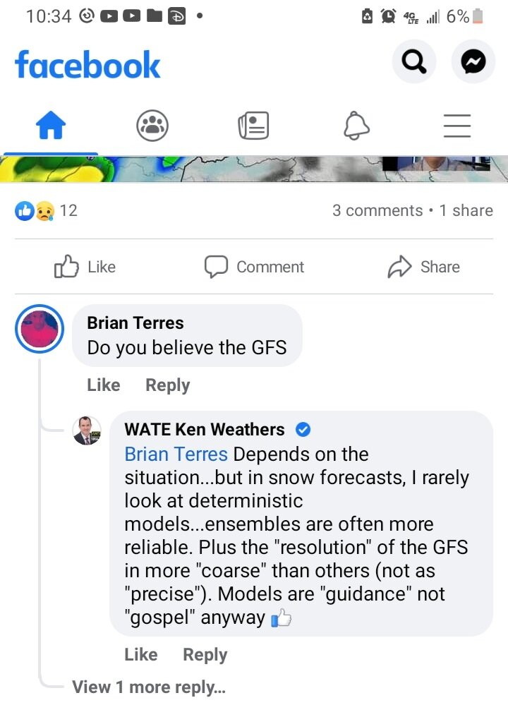
I've seen more intelligent discussions about the weather here than i've heard from Ben Cathey and Ken Weathers combined. -
March 11th-13th Winter Weather Event. Winter's last gasp?
Runman292 replied to Windspeed's topic in Tennessee Valley
I've heard from the grape vines that he gets his forecasts from Miss Cleo.
-
March 11th-13th Winter Weather Event. Winter's last gasp?
Runman292 replied to Windspeed's topic in Tennessee Valley
Lol at "rarely looks at deterministic models".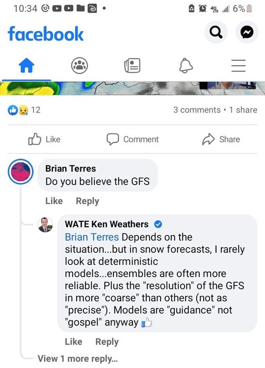
-
March 11th-13th Winter Weather Event. Winter's last gasp?
Runman292 replied to Windspeed's topic in Tennessee Valley
MRX posted a video discussing the event on youtube. https://youtu.be/OfOmwRguDmU -
March 11th-13th Winter Weather Event. Winter's last gasp?
Runman292 replied to Windspeed's topic in Tennessee Valley
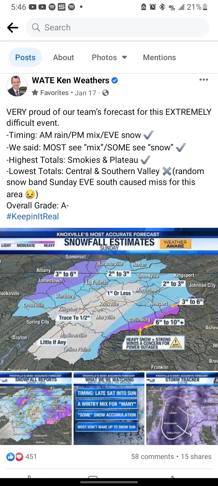
Just found this on MRX's website. Th3 critera is actually different based on location. The central and southern valley are in the 3" or greater zone, while the "horseshoe" counties are in the 4" or greater zone. That is the reason why NE TN is under an advisory and not a warning.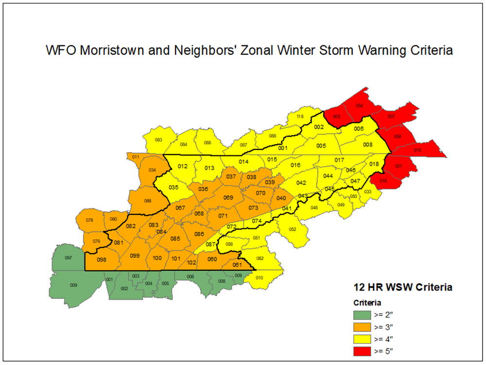
-
March 11th-13th Winter Weather Event. Winter's last gasp?
Runman292 replied to Windspeed's topic in Tennessee Valley
Is the WSW criteria different between southeast TN and NE TN? They literally have the same amounts predicted, but one area has a WSW and the other has a WWA. -
March 11th-13th Winter Weather Event. Winter's last gasp?
Runman292 replied to Windspeed's topic in Tennessee Valley
It's weird to see that portions of NE TN are in a WWA. -
March 11th-13th Winter Weather Event. Winter's last gasp?
Runman292 replied to Windspeed's topic in Tennessee Valley

-
March 11th-13th Winter Weather Event. Winter's last gasp?
Runman292 replied to Windspeed's topic in Tennessee Valley
My favorite is #NoHypeWeather. -
March 11th-13th Winter Weather Event. Winter's last gasp?
Runman292 replied to Windspeed's topic in Tennessee Valley
-
January 28th-29th Clippers/NW Flow Obs/Last Minute Forecasts.
Runman292 replied to John1122's topic in Tennessee Valley
Same here in Oak Ridge. Less than an inch. -
January 28th-29th Clippers/NW Flow Obs/Last Minute Forecasts.
Runman292 replied to John1122's topic in Tennessee Valley
Light snow showers has been falling in Oak Ridge for about 20 minutes. No accumulations so far. -
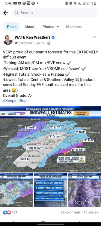
I saw something pretty funny on his facebook page during the day on Sunday. Someone asked him why MRX has higher snow totals forecast than WATE? He responded something like "I respect my collegues in Morristown, but I disagree with them and read the models differently." Along with his #NoHypeWeather and #KeepingitReal hashtags, you can see the arrogance. Something that really bothers me about WATE is their nonstop back patting when it comes to their "most accurate forecast in america" award that they won.