Runman292
-
Posts
766 -
Joined
-
Last visited
Content Type
Profiles
Blogs
Forums
American Weather
Media Demo
Store
Gallery
Everything posted by Runman292
-
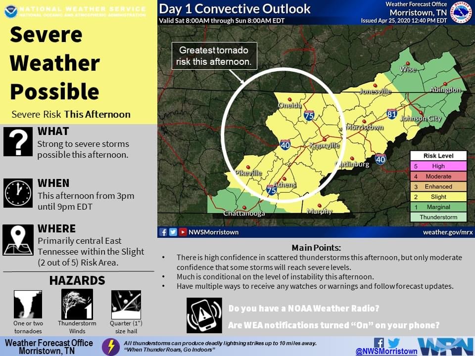
I found the graphic on their Facebook page.
-
In a span of 30-45 minutes, it’s gone from cloudy to mostly sunny in South Knoxville. There’s not a lot of clouds now. I have a bad feeling about this.
-
Here’s the latest graphic from MRX:
-
In the latest update from the SPC, the 5% Tornado probability has expanded into the Eastern Valley.
-
This morning’s short term AFD from MRX: Moving into/through Wednesday, conditions across the TN Valley will improve as the day progresses with the aforementioned low clouds scting out to favor low cu and ample heating amongst sustained sly/swly moisture advection. With that, did keep pops mentionable albeit low during peak heating as iso/sct convection is possible once convective temps are reached (highs in the 70s to low 80s), with low confidence in placement. Meanwhile the synoptic pattern really starts to amplify as a fast moving H5 wave/trough dives out of Canada across the Northern Rockies into the Plains, resulting in surface cyclogenesis across MO/IL. This deepening surface low will propel a fast moving cold front into a very moist/unstable warm sector over the OH Valley late Monday evening with ample convection to accompany. This frontal convection will then race across the Plateau, through the Great Valley, and into the Southern Appalachians around sunrise Thursday. Profiles in the warm sector across East TN are fairly impressive ahead of the convection (despite the timing) with very steep lapse rates amidst deep dry air and unidirectional/strong sheer. As for hazards, nothing is off the table as large hail and damaging winds are certainly the primary threats, but an isolated tornado or two cannot be ruled out as some embedded rotations are likely. Instability does look to wain closer to daybreak as the line of convection moves east, mainly just on diurnal trends, therefore would expect some gradual weakening closer to the NC line. All said, SPC has upgraded areas generally west of I75 to an Enhanced Risk of severe thunderstorms, which is where instability/shear are maximized, while the remainder of the area is essentially favored in the Slight Risk Category. As for timing specifics, the CAMs seem to be in fairly good agreement with only one slower outlier. Typically these fronts outperform as far as speed/timing thus leaned away from the slower outlier thereby favoring a fast fropa between midnight and 5-6AM eastern time.
-
I got a question. When was the last significant severe weather outbreak in East TN? Is it April of 2011?
-
Interesting that the SPC includes East TN in the 15% probability of severe weather, while MRX doesn’t seem to be concerned about seeing severe storms on Wednesday in their latest disco.
-
Tornado Warning in Rhea, Meigs, and Roane counties until 4:45 PM EST.
-
Thankfully, the power only flickered for a few seconds at my place. I did hear a tree fall on my property during the storm.
-
Another Tornado Warning in southern Cumberland county.
-
In the latest update, the enhanced risk didn’t shift west, but it did expand west some. Here’s the latest from the SPC: ...Mid and upper Ohio Valley and central Appalachians, southward into the Southeast... A semi-continuous, roughly north-south band of thunderstorms is expected to be ongoing at the start of the period, extending from southeastern Indiana/southwestern Ohio southward to the Alabama/western Florida Panhandle coasts; while this will likely be a period of relative minimum in severe risk, local risk for damaging winds/hail, and possibly a tornado or two, will likely be ongoing. As the airmass ahead of this initial band destabilizes into the afternoon, storms are expected to reintensify. Damaging winds and some tornado risk may spread across the middle and into the upper Ohio Valley through the afternoon with this band of storms. Meanwhile near and east of the southern Appalachians, reintensification of convection in this band may become more cellular in organization. Given favorably strong flow through the lower and middle troposphere contributing to strong shear, this more cellular storm mode would support risk for a few tornadoes, along with locally damaging winds and some hail. In the wake of this initial band of storms, modest destabilization is expected, likely leading to development of a second band of storms nearer the surface cold front. As this band of storms crosses the middle Ohio Valley/Mid South region, severe risk is anticipated, with damaging winds and tornadoes both possible given the very strong shear residing atop the pre-frontal boundary layer. Risk in any area will be somewhat storm-mode dependent, with a mix of cellular and banded structures possible within the north-south zone ahead of the front.
-
TN valley heavy rain/flooding week of whenever
Runman292 replied to janetjanet998's topic in Tennessee Valley
Edit: Disregard my last post. -
Tornado warning issued for Rhea and Bledsoe counties.
-
SPC has extended the enhanced risk to western parts of east TN.
-
I think they underestimated yesterday's system in regards to the Southern Valley. No watches were issued south of Loudon county and that part of TN seemed to get hit the worst.
-
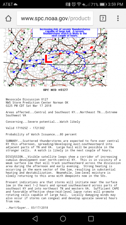
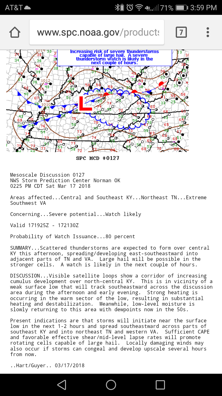
From the NWS SPC: