

MattPetrulli
-
Posts
1,734 -
Joined
-
Last visited
Content Type
Profiles
Blogs
Forums
American Weather
Media Demo
Store
Gallery
Everything posted by MattPetrulli
-
IMO would be surprised to see a tropical storm landfall and not a hurricane landfall out of this but still super early.
-

2023 Atlantic Hurricane season
MattPetrulli replied to Stormchaserchuck1's topic in Tropical Headquarters
-
2023 Atlantic Hurricane season
MattPetrulli replied to Stormchaserchuck1's topic in Tropical Headquarters
Your trolling will be studied in the history books for years to come -
Historic Christmas Lake Effect Blizzard
MattPetrulli replied to BuffaloWeather's topic in Upstate New York/Pennsylvania
Not from the area and casually observe significant NE snow events, so as a region that takes lake effect snow constantly, where will today-Saturday rank all time for Buffalo blizzards, let alone lake effect events? From an outside perspective, high end tropical storm conditions associated with intense snow bands parked over a major metro area for a day or 2 spells absolute disaster but I could be wrong. So overall, what will be the eventual impact and overall historic ranking of this event? -
Historic Christmas Cold & maybe snow?! Dec 23rd-30th
MattPetrulli replied to Wurbus's topic in Tennessee Valley
Only interested in this for the likely high impact wind event and the cold snap. Don't care for .5 inches of snow -
Going off 2 AM motion, should expect landfall around 3:30 AM or before. Also formed quite a large CDO despite dry air
-
...2 AM EST POSITION UPDATE OF NICOLE... ...STRONG WINDS, DANGEROUS STORM SURGE AND WAVES, AND HEAVY RAINS CONTINUE AS NICOLE NEARS THE EAST COAST OF FLORIDA... NOAA buoy 41009, located about 25 miles east of Cape Canaveral, Florida, recently reported a sustained wind of 49 mph (79 km/h) and a wind gust to 65 mph (104 km/h). A weather station at Patrick Air Force Base recently reported a sustained wind of 53 mph (85 km/h) with a wind gust of 61 mph (98 km/h). A NOAA tide gauge at Fernandina Beach, Florida observed a water level of 4.5 feet above Mean Higher High Water. SUMMARY OF 200 AM EST...0700 UTC...INFORMATION --------------------------------------------------- LOCATION...27.4N 80.1W ABOUT 15 MI...20 KM E OF FORT PIERCE FLORIDA MAXIMUM SUSTAINED WINDS...75 MPH...120 KM/H PRESENT MOVEMENT...WNW OR 290 DEGREES AT 14 MPH...22 KM/H MINIMUM CENTRAL PRESSURE...980 MB...28.94 INCHES
-
Hurricane Nicole Tropical Cyclone Update NWS National Hurricane Center Miami FL AL172022 1200 AM EST Thu Nov 10 2022 ...12 AM EST POSITION UPDATE OF NICOLE... ...NICOLE BRINGING STRONG WINDS, A DANGEROUS STORM SURGE, AND HEAVY RAINS AS IT APPROACHES THE EAST COAST OF FLORIDA... A weather station at Sebastian Inlet, Florida, recently reported a sustained wind of 48 mph (77 km/h) with a wind gust of 66 mph (106 km/h). A WeatherSTEM station near Stuart Beach, Florida, recently reported a sustained wind of 47 mph (76 km/h) with a wind gust of 62 mph (100 km/h). SUMMARY OF 1200 AM EST...0500 UTC...INFORMATION --------------------------------------------------- LOCATION...27.1N 79.6W ABOUT 50 MI...80 KM ESE OF FORT PIERCE FLORIDA MAXIMUM SUSTAINED WINDS...75 MPH...120 KM/H PRESENT MOVEMENT...WNW OR 285 DEGREES AT 13 MPH...20 KM/H MINIMUM CENTRAL PRESSURE...980 MB...28.94 INCHES
-
Believe its the first US station, but Vero Beach is at 39/52 first official tropical storm condition verified station.
-
75 knot SFMR in NE eyewall
-
Eyewall seems open to the south, will probably fill in with frictional convergence eventually though. Thought 80-85 MPH would be easily obtained but LF intensity may end up being just 60-65 knots
-
A little temperature increase when going over the center, maybe an attempt to form an inner core despite the mid satellite presentation. .
-
Major November Outbreak Possible
MattPetrulli replied to Tallis Rockwell's topic in Central/Western States
-
2022 Atlantic Hurricane season
MattPetrulli replied to StormchaserChuck!'s topic in Tropical Headquarters
Interesting 12z Euro and EPS -
2022 Atlantic Hurricane season
MattPetrulli replied to StormchaserChuck!'s topic in Tropical Headquarters
Little uptick on 18z GEFS in WCAB -
Julia | 85 mph 982 mb peak | EPAC Crossover #2
MattPetrulli replied to Iceresistance's topic in Tropical Headquarters
Seems like NHC satellite estimates were very close if not right on the money -
Fall 2022 Medium/Long Range Forecast Discussion
MattPetrulli replied to Carvers Gap's topic in Tennessee Valley
Pain I want more Summer -
2022 Atlantic Hurricane season
MattPetrulli replied to StormchaserChuck!'s topic in Tropical Headquarters
12z Euro alluded to this also. I don't think we'll get anything too significant considering incoming trough may force it south and/or impose shear and dry air, but it's worth watching. -
Julia | 85 mph 982 mb peak | EPAC Crossover #2
MattPetrulli replied to Iceresistance's topic in Tropical Headquarters
GEFS inconsistency takes years off my life That being said if something goes down in Caribbean as others have stated I think it's more of a Central America threat but our models stink so anything is possible.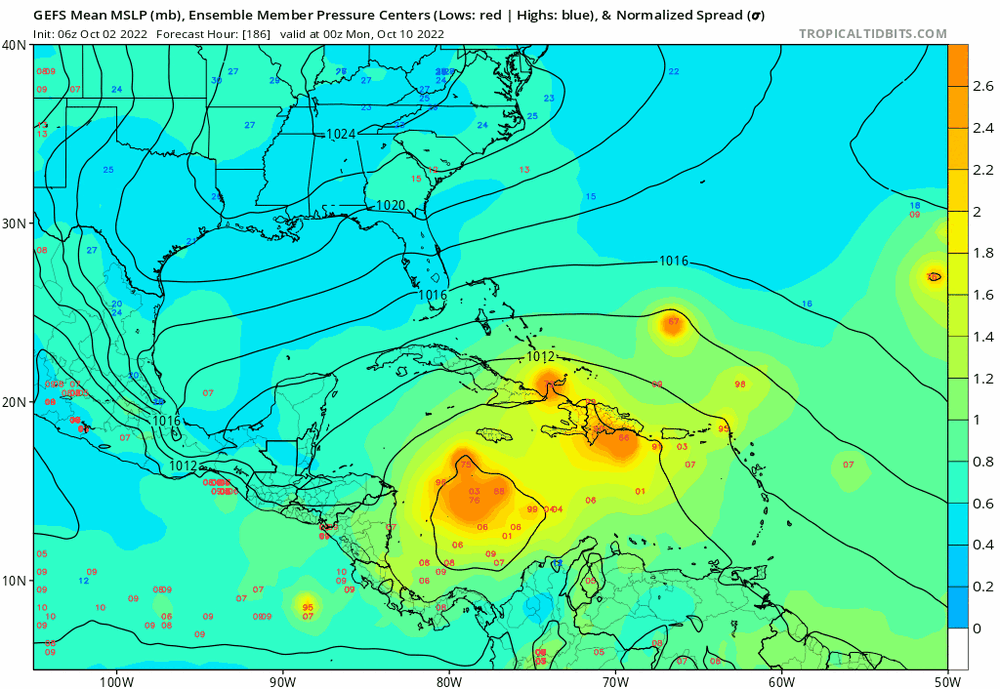
-
Yeah, I am having trouble believing the hundreds of bodies things. Usually USA hurricanes don't really directly kill 100+ people, obviously Katrina and Maria exceptions. A lot of the deaths occur afterwards. For example, Ike and Harvey which impacted the extremely populated Houston area had about 68 direct and 18 direct deaths. Other modern hurricanes like Ida, Michael, Sandy, Irma which were catastrophic in their own rights and did an extreme amount of damage all had "only" 50-100 direct deaths. These are all sourced from Wikipedia and I haven't done any digging of my own but if those numbers are false, it likely isn't much higher than reported. 50-100 is a lot of fatalities don't get me wrong but it's just proving to the point of Ian. Ian killing "hundreds" directly in today's modern era would be a very hard thing to do. Chances are, those reports are exaggerated. However, it would be arrogant of me to assume it's 100% false as I have seen those hundreds of deaths reports on social media. There were also multiple chasers reporting seeing fatalities on their own. I would still lean it being exaggerated but it's an unsettling amount of people that are saying its hundreds of fatalities.
-
2022 Atlantic Hurricane season
MattPetrulli replied to StormchaserChuck!'s topic in Tropical Headquarters
No rest for the weary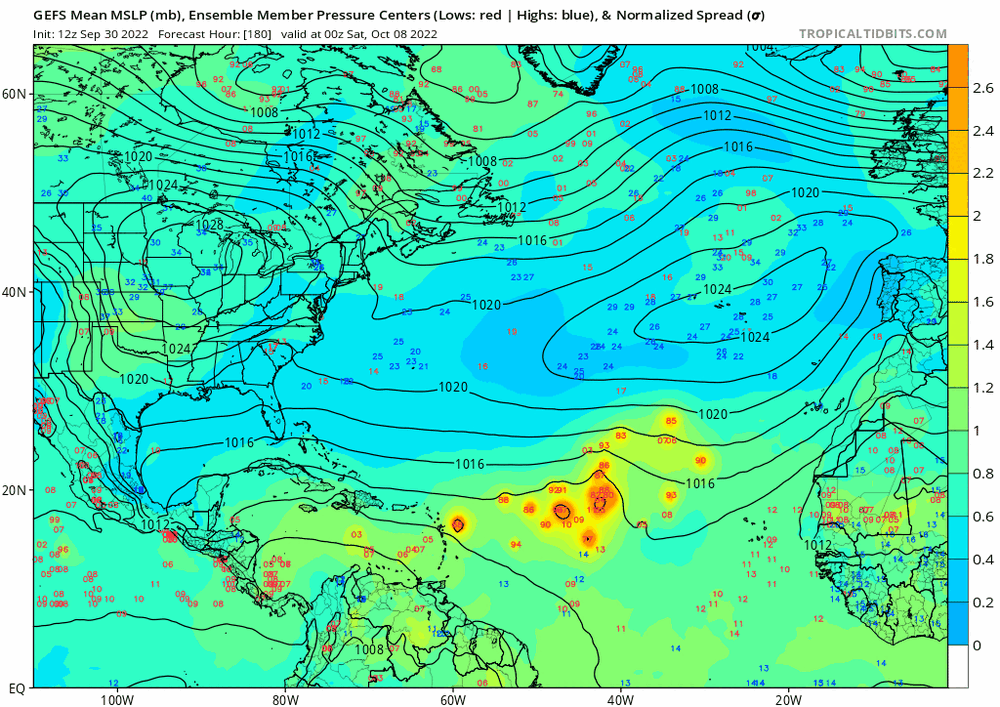
-
Large amount of wind damage reports coming in far inland.
-
Just saw this too A WeatherFlow station at Morris Island Lighthouse recently reported sustained winds of 75 mph (120 km/h) with a gust to 82 mph
-
At first thought winds were unimpressive vs yesterday with the wind field. However, a lot of damage reports are coming in and North Charleston is sustained at 51 gusting to 68.


