-
Posts
1,734 -
Joined
-
Last visited
Content Type
Profiles
Blogs
Forums
American Weather
Media Demo
Store
Gallery
Everything posted by MattPetrulli
-
Jan 30th-February 1st 2026 Arctic Blast/ULL Snow OBS Thread.
MattPetrulli replied to John1122's topic in Tennessee Valley
3-4" E of Sevierville. -

1-30/2-1-26 Arctic Blast, ULL Snow Event
MattPetrulli replied to John1122's topic in Tennessee Valley
RAP on board So we're really doing this huh- 782 replies
-
- 6
-

-

-
- extreme cold
- snow
-
(and 1 more)
Tagged with:
-

1-30/2-1-26 Arctic Blast, ULL Snow Event
MattPetrulli replied to John1122's topic in Tennessee Valley
- 782 replies
-
- 2
-

-
- extreme cold
- snow
-
(and 1 more)
Tagged with:
-
That's sevier county including Mt Leconte I believe.
-
Anyone know single day snowfall record for Sevierville? I tried finding records but couldn't and asked MRX but they haven't responded yet. Asking incase it gets surpassed this weekend.
-
-
-
What METAR placefile are you using?
-
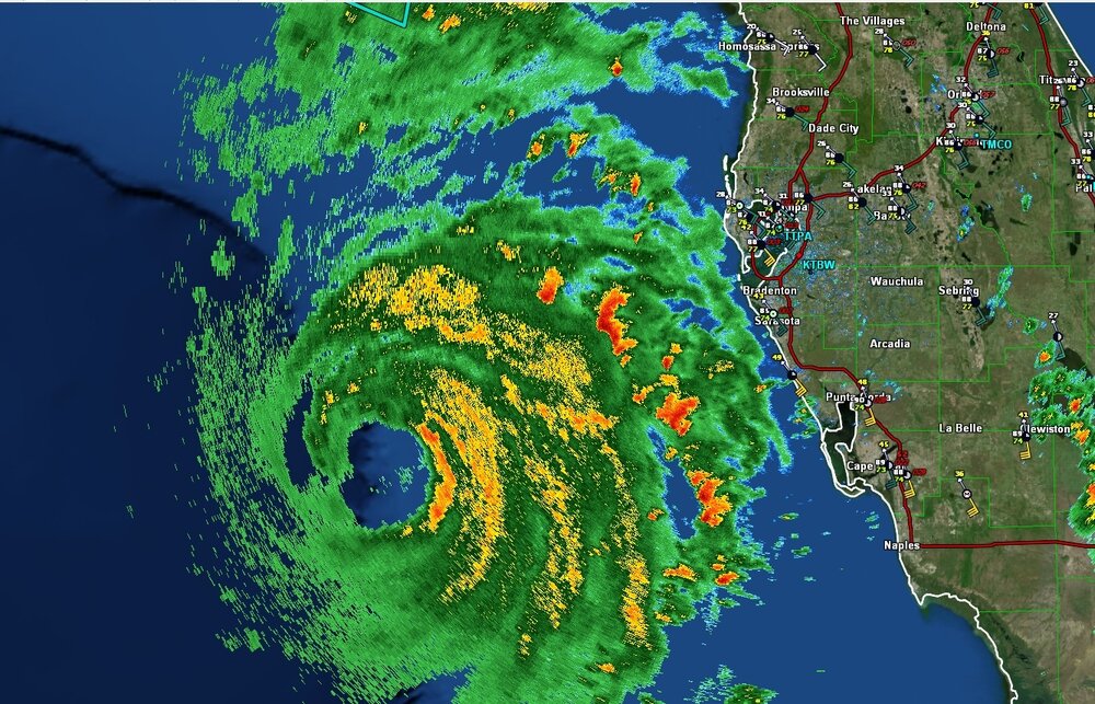
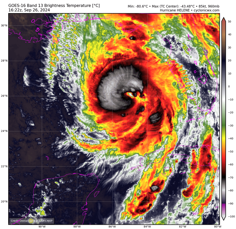
Despite the southern eyewall opening on radar, VDM says its closed. Also, velocities continue to intensify on radar, Helene is still intensifying.
-
SE eyewall has new VHTs going up + eye warming rather rapidly.
-
Looking ever increasingly better, imo think we can get to 120-125 knots at LF. Still several hours left over water.
-
500 PM EDT Thu Sep 26 2024 ...HELENE IS A VERY DANGEROUS AND LARGE MAJOR HURRICANE... ...DAMAGING HURRICANE WINDS AND CATASTROPHIC STORM SURGE EXPECTED TO BEGIN IN THE FLORIDA BIG BEND THIS EVENING... SUMMARY OF 500 PM EDT...2100 UTC...INFORMATION ---------------------------------------------- LOCATION...27.9N 84.6W ABOUT 130 MI...205 KM W OF TAMPA FLORIDA ABOUT 175 MI...280 KM S OF TALLAHASSEE FLORIDA MAXIMUM SUSTAINED WINDS...125 MPH...205 KM/H PRESENT MOVEMENT...NNE OR 25 DEGREES AT 23 MPH...37 KM/H MINIMUM CENTRAL PRESSURE...951 MB...28.09 INCHES
-
...AIR FORCE HURRICANE HUNTERS FIND HELENE A MAJOR HURRICANE... The Air Force Hurricane Hunters found that the maximum sustained winds have increased to near 120 mph (195 km/h). This makes Helene a dangerous category 3 major hurricane. Additional strengthening is expected before Helene makes landfall in the Florida Big Bend this evening. SUMMARY OF 225 PM EDT...1825 UTC...INFORMATION ---------------------------------------------- LOCATION...26.7N 84.9W ABOUT 170 MI...280 KM WSW OF TAMPA FLORIDA ABOUT 205 MI...335 KM S OF APALACHICOLA FLORIDA MAXIMUM SUSTAINED WINDS...120 MPH...195 KM/H PRESENT MOVEMENT...NNE OR 25 DEGREES AT 16 MPH...26 KM/H MINIMUM CENTRAL PRESSURE...959 MB...28.32 INCHES
-
Disagree. We still got 8-ish hours until landfalls and it's already at 95-100 knots. I wouldn't call 115 knots unlikely.
-
FL reduction would support a cat 3 upgrade.
-
115 Knot FL last pass, 956.6 HPA
-
-
958.3 extra
-
Dual rotating VHTs on each side now
-
-
It's subsidence from the VHTs
-
Latest VDM is closed eyewall. Off to the races now
-
Thought so too, but NHC is still using the catastrophic wind wording which is used for category 4+ only so I think it's just the forecast point.
-
Kinda getting Ida vibes. Ida kinda struggled/gradually intensified throughout the day before LF with dry air I believe (though this dry air is more significant I think) then exploded over like a 12 hour period. Granted, Ida was smaller than what Helene is/will be, thus exacerbating the rate of intensification. Also Helene has more time than what Ida did at this time.


