

MattPetrulli
-
Posts
1,734 -
Joined
-
Last visited
Content Type
Profiles
Blogs
Forums
American Weather
Media Demo
Store
Gallery
Everything posted by MattPetrulli
-
 158 knot unflagged SFMR
 -
Wow. Blend supports 155 knot+
-
4/1-4/2 severe threat (southern portion of subforum)
MattPetrulli replied to largetornado's topic in Lakes/Ohio Valley
I like 4/2's potential a lot. Potential is there for a substantial event. -
Went outside, got a thin glaze of ice on the car. Probably will keep me home tomorrow. Pretty impressed with how widespread the freezing rain is.
- 372 replies
-
- 1
-

-
- cold
- arctic blast
- (and 1 more)
-
All the METARs in the region are at 32 or lower. This makes me think this is a big batch of freezing rain. w
- 372 replies
-
- 2
-
-
- cold
- arctic blast
- (and 1 more)
-
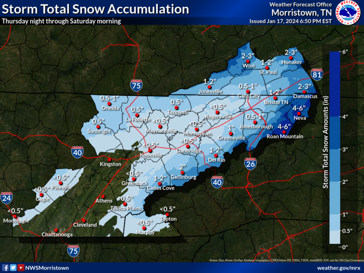
MRX updated their snow map I actually think they're being too aggressive, at least for Sevier County.
- 372 replies
-
- 5
-
-
- cold
- arctic blast
- (and 1 more)
-
Once again Euro vs GFS. GFS is kind of the outlier here, only model in its camp is the ICON. The rest are just a slushy mix for most of the valley.
- 372 replies
-
- 1
-
-
- cold
- arctic blast
- (and 1 more)
-
January 15th-17th 2024 Arctic Blast/Snow Event
MattPetrulli replied to John1122's topic in Tennessee Valley
Still a mix here. One of the most disappointing forecast busts, if not the most I have ever experienced. -
January 15th-17th 2024 Arctic Blast/Snow Event
MattPetrulli replied to John1122's topic in Tennessee Valley
I hope this band coming in gives an inch or 2 -
January 15th-17th 2024 Arctic Blast/Snow Event
MattPetrulli replied to John1122's topic in Tennessee Valley
Heavy snow in Sevierville finally. Maybe too little too late though. -
January 15th-17th 2024 Arctic Blast/Snow Event
MattPetrulli replied to John1122's topic in Tennessee Valley
No power and a cold rain in Sevierville . -
January 15th-17th 2024 Arctic Blast/Snow Event
MattPetrulli replied to John1122's topic in Tennessee Valley
We’ve run into a massive problem in Sevier County.. mixing. HRRR has us being stuck in a mix all day. While it looks like it’s snowing hard on radar here, it’s not. This is extremely disappointing and frustrating if it ends up winning out. . -
January 15th-17th 2024 Arctic Blast/Snow Event
MattPetrulli replied to John1122's topic in Tennessee Valley
Still a bit worried about the warm nose, but if that isn't a problem, I can see Sevier County overperforming. Especially given the HRRR dry bias. -
January 15th-17th 2024 Arctic Blast/Snow Event
MattPetrulli replied to John1122's topic in Tennessee Valley
Well, the warm nose has made a reappearance. -
January 15th-17th 2024 Arctic Blast/Snow Event
MattPetrulli replied to John1122's topic in Tennessee Valley
Lol am I being trolled? EDIT: Showcasing HRRR dry bias -
January 15th-17th 2024 Arctic Blast/Snow Event
MattPetrulli replied to John1122's topic in Tennessee Valley
Really excited about these rates. Hopefully can exceed an inch+ an hour. -
January 15th-17th 2024 Arctic Blast/Snow Event
MattPetrulli replied to John1122's topic in Tennessee Valley
TYS reporting moderate snow with this band, first real band about to come through. -
January 15th-17th 2024 Arctic Blast/Snow Event
MattPetrulli replied to John1122's topic in Tennessee Valley
Classic HRRR dry bias . -
January 15th-17th 2024 Arctic Blast/Snow Event
MattPetrulli replied to John1122's topic in Tennessee Valley
All 00z models including CAMS paste the Valley. Nam family is on an island. Becoming more and more optimistic for a good snow event -
January 15th-17th 2024 Arctic Blast/Snow Event
MattPetrulli replied to John1122's topic in Tennessee Valley
OHX and MRX going conservative on snow totals -
January 15th-17th 2024 Arctic Blast/Snow Event
MattPetrulli replied to John1122's topic in Tennessee Valley
I'm worried about mixing in Sevier County. RGEM, ICON, HRRR, NAM, NAM3K, even the 18z GFS show a possibility of this. Really want a FV3 type of solution with all snow, but am afraid that possibility is beginning to fade. Still a lot of time for change, but after so many disappointing winters/setups, I am greedy for snow. -
January 15th-17th 2024 Arctic Blast/Snow Event
MattPetrulli replied to John1122's topic in Tennessee Valley

