

MattPetrulli
-
Posts
1,734 -
Joined
-
Last visited
Content Type
Profiles
Blogs
Forums
American Weather
Media Demo
Store
Gallery
Everything posted by MattPetrulli
-
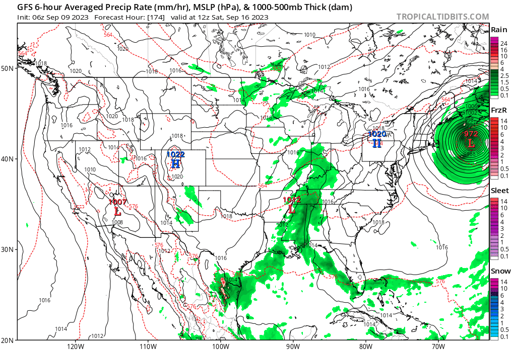
Thing is, even if its a NS landfall, it's pretty obvious this can end up being just as significant if not worse for the USA, given the lack of a compact core by then.
-
I don't think LF should focused upon as much as it should be for compact systems. It can landfall in NS and still be some pretty significant impacts for NE. Especially since there probably won't be a definite wind max at that stage and convection will primarily be focused to the west and NW.
-
Tried to take a general picture to best show it, but this is the induation map for a category 1 hurricane worst case scenario surge. Lots of orange/red even for a cat 1.
-
Great thread
-
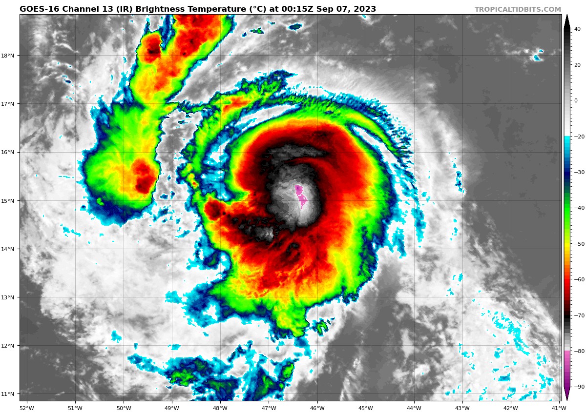
Probably have a 120 MPH hurricane right now
-
-
Once again asking what the problem is considering the GFS almost did that exact same analog lol.
-
What's the problem with this post?
-
Every 18z suite model shows intensification back into a mid-high end category 4 at the very least. That is, besides the HWRF and GFS which kinda keep it steady state.
-
Hmmmmm

-
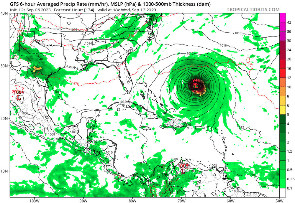
Funny how the Euro suite is the one to the west and the GFS/GEFS suite is one to the east. Usually vice versa lol. I think a US impact has become slightly more probable today, esp if it ends up going into Nova Scotia like what a lot of GEFS suggest. Getting harder to avoid at least a close shave.
-
Be careful, you're a wishcaster for posting that. But seriously, this trend reminds me a bit of Henri and Florence when they were pretty cleanly forecast OTS and that didn't happen. It's a game of trends, am also extremely curious to see if any trough interactions creates any kind of PRE event.
-
Skull

-
Read more, post less. Making a relevant meteorological observation on a model run is not wishcasting. As has been pointed out, there's clearly continuation of a southern/slower trend on 18z GFS. Downcasting is just as bad as wishcasting.
-
The GFS is a pathetic model
.thumb.gif.5c7a9aad9630acdebca84ba3e77a6497.gif)
-
These are pretty far south compared to the Euro. Would favor a recurse atm, but definitely don't think it's auto fish or anything. Especially if it ends up weaker than modeled, which is becoming a bit more possible today, and heads more south/west than currently projected.
-

2023 Atlantic Hurricane season
MattPetrulli replied to Stormchaserchuck1's topic in Tropical Headquarters
-
See you guys here on page 60 of the thread next week
-
Curious to see how close this can get to Savannah, as it looks like the main circulation itself may go right over the city.
-
I was thinking some of the surge forecast was gonna be a little off, but with high tide still coming up and a constant onshore flow, I can see at least someone verifying 10-12+. My guess would be Horseshoe Beach .
-
Perry also may receive a direct eyewall hit. Reminds me a bit of Houma from Ida.
-
Horseshoe Beach seems to have 6-7 ft+ ongoing and is gonna be in a band for a little bit that exacerbates it. This may be ground zero for surge damage.
-
Cedar Key is approaching 10 ft If Horseshoe beach manages to stay in the band a little longer I can see them surpassing Cedar Key, esp with back flow.
-


.gif.b3ff5832efbfbc93f3ce04cdf0426ad3.gif)