MattPetrulli
-
Posts
1,734 -
Joined
-
Last visited
Content Type
Profiles
Blogs
Forums
American Weather
Media Demo
Store
Gallery
Everything posted by MattPetrulli
-

2021 Atlantic Hurricane season
MattPetrulli replied to StormchaserChuck!'s topic in Tropical Headquarters
12z Euro develops the disturbance in the Caribbean and moves it along the TX coast as a weak system, pretty much the only model showing development of that though besides a few GEFS ensembles. Another thing to watch is a wave that'll be coming through the Bahamas late next week, GFS and Euro don't show development atm, but several GEFS members have been consistent on developing it for several runs, so something to watch -
Tropical Storm Mindy Max Winds 45Mph
MattPetrulli replied to SnowenOutThere's topic in Tropical Headquarters
...CENTER OF MINDY MAKES LANDFALL AT ST. VINCENT ISLAND FLORIDA... National Weather Service Doppler radar data and surface observations indicate that the center of Mindy has made landfall over St. Vincent Island, Florida. The Tyndall Air Force Base tower south of Apalachicola, Florida, recently reported sustained winds of 44 mph (70 km/h) and a wind gust of 55 mph (89 km/h) at an elevation of 115 ft (35 m). SUMMARY OF 815 PM CDT...0115 UTC...INFORMATION --------------------------------------------------- LOCATION...29.7N 85.2W ABOUT 10 MI...15 KM WSW OF APALACHICOLA FLORIDA MAXIMUM SUSTAINED WINDS...45 MPH...75 KM/H PRESENT MOVEMENT...NE OR 50 DEGREES AT 21 MPH...33 KM/H MINIMUM CENTRAL PRESSURE...1004 MB...29.65 INCHES Definitely one of the better 40 knot tropical storms I have seen on radar -
Tropical Storm Mindy Max Winds 45Mph
MattPetrulli replied to SnowenOutThere's topic in Tropical Headquarters
Almost a partial eyewall like feature created by frictional convergence as it's coming ashore, wouldn't be surprised if it was a 45 knot TS currently. -
Tropical Storm Mindy Max Winds 45Mph
MattPetrulli replied to SnowenOutThere's topic in Tropical Headquarters
500 PM CDT Wed Sep 08 2021 ...NOAA BUOY DATA INDICATES THAT MINDY IS A LITTLE STRONGER... Recent data from NOAA buoy 42036 indicates that the maximum sustained winds in Mindy are now near 45 mph (75 km/h) with higher gusts. SUMMARY OF 500 PM CDT...2200 UTC...INFORMATION --------------------------------------------------- LOCATION...29.2N 86.1W ABOUT 75 MI...120 KM WSW OF APALACHICOLA FLORIDA MAXIMUM SUSTAINED WINDS...45 MPH...75 KM/H PRESENT MOVEMENT...NE OR 50 DEGREES AT 21 MPH...33 KM/H MINIMUM CENTRAL PRESSURE...1004 MB...29.65 INCHES -
Tropical Storm Mindy Max Winds 45Mph
MattPetrulli replied to SnowenOutThere's topic in Tropical Headquarters
Now have Mindy ...NEW TROPICAL STORM FORMS IN THE NORTHEAST GULF OF MEXICO... ...TROPICAL STORM WARNINGS ISSUED FOR THE FLORIDA PANHANDLE... SUMMARY OF 400 PM CDT...2100 UTC...INFORMATION ---------------------------------------------- LOCATION...29.0N 86.3W ABOUT 90 MI...150 KM WSW OF APALACHICOLA FLORIDA MAXIMUM SUSTAINED WINDS...40 MPH...65 KM/H PRESENT MOVEMENT...NE OR 50 DEGREES AT 21 MPH...33 KM/H MINIMUM CENTRAL PRESSURE...1008 MB...29.77 INCHES WATCHES AND WARNINGS -------------------- CHANGES WITH THIS ADVISORY: A Tropical Storm Warning has been issued for the coast of the Florida Panhandle from Mexico Beach to Steinhatchee River. -
Tropical Storm Mindy Max Winds 45Mph
MattPetrulli replied to SnowenOutThere's topic in Tropical Headquarters
1. Updated: Satellite and radar data indicate that shower and thunderstorm activity continues to gradually become better organized in association with an area of low pressure located about 115 miles southwest of Apalachicola, Florida. In addition, satellite-derived wind data indicate that the circulation has become somewhat better defined today. If these development trends continue, advisories will likely be initiated on this system as a tropical depression or tropical storm later this afternoon, and tropical storm warnings could be required for portions of the coast of the Florida Panhandle. After reaching the Florida Panhandle tonight, this system is expected to move across the southeastern United States and emerge over the western Atlantic by late Thursday, where environmental conditions appear unfavorable for additional development. Regardless of development, areas of heavy rainfall are likely across portions of the Florida panhandle and southern Georgia through Thursday, with localized flooding possible. * Formation chance through 48 hours...high...80 percent. * Formation chance through 5 days...high...80 percent. Looks pretty close to a tropical system to me imo -
Tropical Storm Mindy Max Winds 45Mph
MattPetrulli replied to SnowenOutThere's topic in Tropical Headquarters
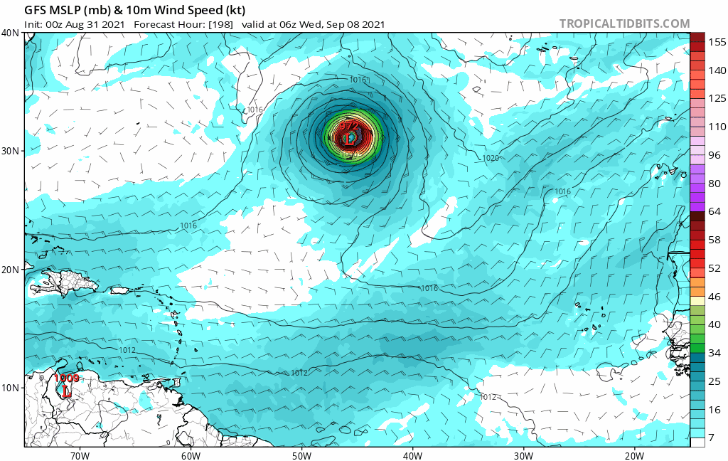
00z GFS, HWRF, and HMON spin this up really quick into a weak tropical storm tomorrow evening Reminds me somewhat of what happened with TS Emily (2017) which spun up really quick into a 40 knot tropical storm near the coast, that's the only similarity I am aware of though. -
2021 Atlantic Hurricane season
MattPetrulli replied to StormchaserChuck!'s topic in Tropical Headquarters
Can definitely see 91L developing into a tropical depression or weak storm as it nears the coast given GEFS ensembles Imo the one to really watch is the CAG system which GEFS, GFS, and CMC have been relatively consistent on developing. -
2021 Atlantic Hurricane season
MattPetrulli replied to StormchaserChuck!'s topic in Tropical Headquarters
What is the point of logging on to this website just to troll -
Those are some insane rates going into the Metro area
-
...TORNADO EMERGENCY FOR Bristol Croydon and Burlington... The National Weather Service in Mount Holly NJ has issued a * Tornado Warning for... Central Mercer County in central New Jersey... Northwestern Burlington County in southern New Jersey... Southeastern Bucks County in southeastern Pennsylvania... * Until 730 PM EDT. * At 702 PM EDT, a confirmed large and destructive tornado was observed over Beverly, or 12 miles southwest of Trenton, moving northeast at 40 mph. TORNADO EMERGENCY for Bristol Croydon and Burlington. This is a 0 PARTICULARLY DANGEROUS SITUATION. TAKE COVER NOW! HAZARD...Deadly tornado. SOURCE...Radar confirmed tornado. IMPACT...You are in a life-threatening situation. Flying debris may be deadly to those caught without shelter. Mobile homes will be destroyed. Considerable damage to homes, businesses, and vehicles is likely and complete destruction is possible. * Locations impacted include... Trenton, Bensalem, Ewing, Willingboro, Florence, Burlington, Bristol, Bordentown, Pennington, Beverly, Yardley, Tullytown, Langhorne, Washington Crossing, Windsor, Florence-Roebling, Woodside, Edinburg, White Horse and Andalusia. This includes the following highways... New Jersey Turnpike between exits 6 and 6A. Pennsylvania Turnpike between mile markers 353 and 359. Interstate 95 in Pennsylvania between mile markers 34 and 40. Interstate 195 in New Jersey between mile markers 0 and 5. Interstate 295 in New Jersey between mile markers 57 and 76. PRECAUTIONARY/PREPAREDNESS ACTIONS... To repeat, a large, extremely dangerous and potentially deadly tornado has been confirmed. To protect your life, TAKE COVER NOW! Move to an interior room on the lowest floor of a sturdy building. Avoid windows. If in a mobile home, a vehicle or outdoors, move to the closest substantial shelter and protect yourself from flying debris.
- 487 replies
-
- 1
-

-
- hurricane
- flooding potential
- (and 2 more)
-
Good pics but holy crap at that!!!
-
Imo there's like a 95% it just runs up ACE but GFS has also been trending further south and west so am not 100% sold

-
2021 Atlantic Hurricane season
MattPetrulli replied to StormchaserChuck!'s topic in Tropical Headquarters
If this is like your other predictions, looks like a record September is in store. -
Scratch that then lol
-
It's early but I am not entirely sure if that 12-16 ft surge verified, and if it did it seems like it was mostly over uninhabited areas. Highest report I saw was about 10 ft Laplace. Obviously, am open to be proven wrong.
-
Issac should've been retired too, the I curse lives on
-
-
2021 Atlantic Hurricane season
MattPetrulli replied to StormchaserChuck!'s topic in Tropical Headquarters
Sigh -
-
-
-
new FFE
-
-