MattPetrulli
-
Posts
1,734 -
Joined
-
Last visited
Content Type
Profiles
Blogs
Forums
American Weather
Media Demo
Store
Gallery
Everything posted by MattPetrulli
-
Still waiting for that Miami Hurricane hit
-
Please stop man there isn't gonna be a hurricane hitting Miami. If there is I will eat my words but there's currently absolutely no support for such a scenario.
-
Can we please relax on the major hurricane talk until it passes DR??? Kind of jumping the gun a lot here.
-
Who cares the point is there's a tornado in progress. Anyways cell to the east near Stanhope has a cc drop and has a confirmed tornado.
-
Impressive wind gusts to 75 and 81 in Tybee Island and Forest Beach in the last half hour.
-
Barry exists
-
Yeah that isn't a hurricane anymore judging off radar/recon data. Still probably gonna give Tampa/Clearwater area an interesting night.
-
Ohhhhh I misinterpreted that as I thought you said I made a typo. Yeah right now seems actually like an actual tropical storm for the first time in about a day and a half.
-
Pressure at 5 PM was 1009 MB and its down to 1005 MB at 8 PM so I am not understanding.
-
8 PM advisory has pressure down to 1005 MB. Also W at 15 MPH
-
Ends with a cat 1 into Ft Myers Tuesday but I am not sure how good that's worth given its rather very quick intensification overnight tonight.
-
00z GFS pretty far west and is into the big bend Wednesday night as a strong hurricane.
-

2021 Atlantic Hurricane season
MattPetrulli replied to StormchaserChuck!'s topic in Tropical Headquarters
HWRF too -
Severe Weather April 6th-10th 2021
MattPetrulli replied to cheese007's topic in Central/Western States
Both of those DFW cells have decent mesos, something to watch. -
HRRR has been consistent on developing cells further south into the valley. Curious to see if this occurs or not and what those cells will do given the tornadic cells in North TN.
-
Likely a TDS for 2 scans that came close or crossed SR 63. Luckily I remembered that place as being pretty rural, however there are definitely structures scattered about there.
-
Severe Weather April 6th-10th 2021
MattPetrulli replied to cheese007's topic in Central/Western States
So if Friday continues to trend in the wrong direction (hopefully not an early morning severe wx outbreak), is this going to be the main thread or is a new thread gonna be made in the SE subforum? -

-
Those 2 TOR warned cells in South AR are absolute units too.
-
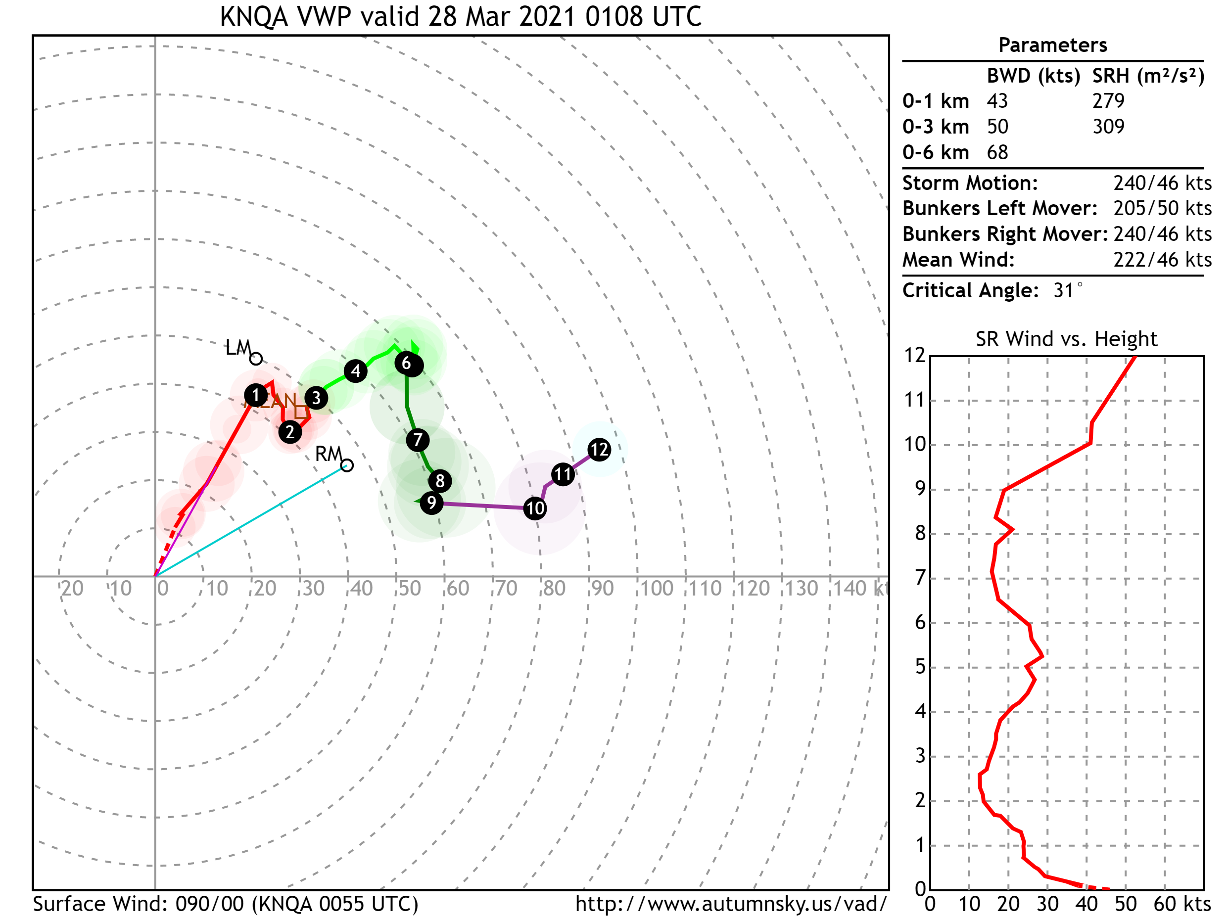
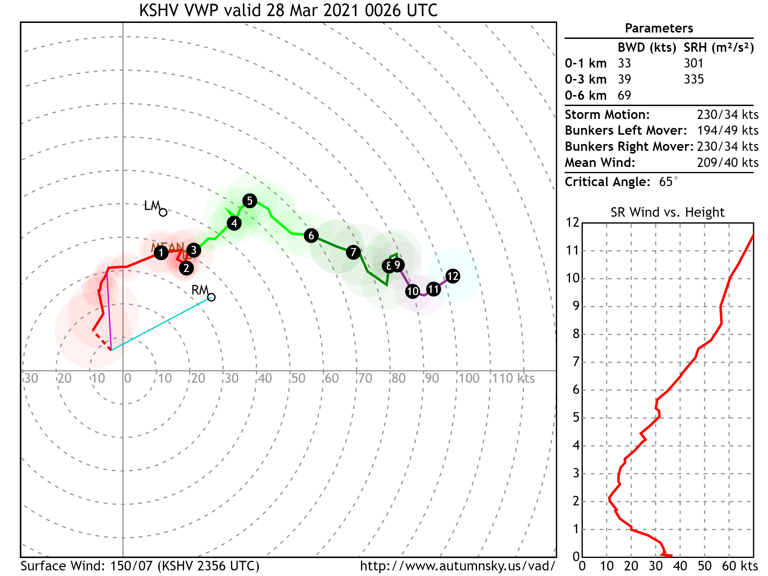
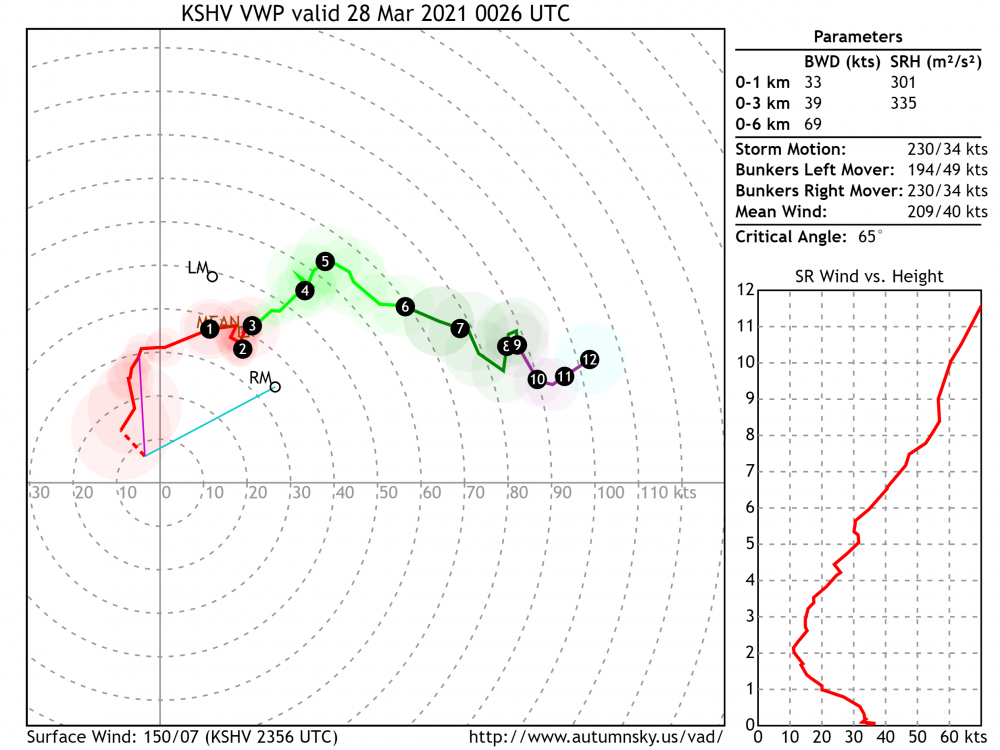
Seems like its about to complete a cycle, SHV VWP rapidly improving.
-
9 Active tornado warnings atm...
-
Interesting thread regarding tor potential today
-
SPC probably saw 17z HRRR and decided for 80/60 probs
-
Fairly large MD too.
-
Likely gonna start raining debris in Downtown ATL too.. massive fallout out ahead.