MattPetrulli
-
Posts
1,734 -
Joined
-
Last visited
Content Type
Profiles
Blogs
Forums
American Weather
Media Demo
Store
Gallery
Everything posted by MattPetrulli
-
-
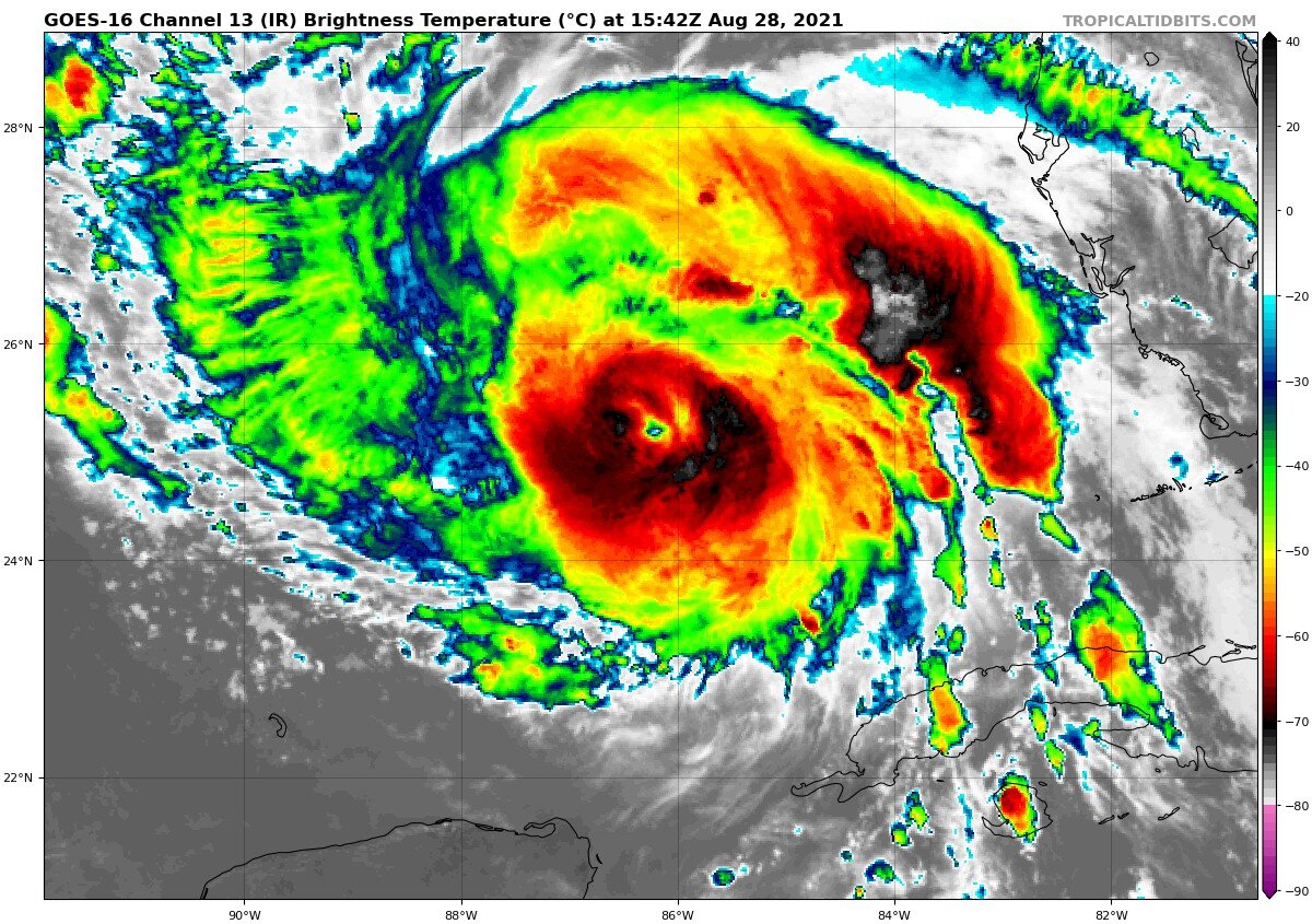
Despite an improving eye with organization, there has been a notable warming of eyewall convention in last hour or two. Probably won't continue, but important to note

-
Spaghettis really trending up at 18z
-
If Henri was that bad, sandy must have been absolutely horrible every single NAM run.
-
I was unfortunately subject to NAM play by play in the Henri forum last week that will not be happening again I hope.
-
-

2021 Atlantic Hurricane season
MattPetrulli replied to StormchaserChuck!'s topic in Tropical Headquarters
18z GFS hasn't finished with a landfall yet but I have seen enough hahaha -
Very heavy indeed
-
HRRR really fumbled the NYC metro flooding
- 1,603 replies
-
- 1
-

-
- hurricane gusts
- flooding rains
- (and 2 more)
-
A few inches????? Nah we chase half inches
-
Man, for the sake of quality threads I hope the next tropical system is not within 3 universes of New England.
-
But my hurricane doesn't look like Hayian! Must be a bust!
-
https://twitter.com/AnthonyMweather/status/1428903927144124418/photo/1
-
Why am I watching a NAM play by play of a tropical system
-
Imo will end up substantially more costly than Elsa because of inland impacts like these.
-
Historic Tennessee Valley Cold, Snow, and Ice Events
MattPetrulli replied to Carvers Gap's topic in Tennessee Valley
I was wondering if there was an efficient way to look at old snow events in east TN. I am looking for a snow event around January 2010 that produced several inches in my area but can't find any articles or anything about it. -
Seems like an eye starting to poke out
-
West trend continues on 00z and we got a LF

-
Clear trend on last few GFS runs to the west with a faster storm
-
Circulation seems very to completely exposed via recon positioning, but not certain without visible satellite.
-
Now have TD 8, NHC notes a 65 MPH peak and a low confidence forecast Tropical Depression Eight Discussion Number 1 NWS National Hurricane Center Miami FL AL082021 1100 PM AST Sun Aug 15 2021 A small well-defined low pressure system located just east-northeast of Bermuda has produced persistent deep convection since this morning. Radar imagery from Bermuda along with geostationary and polar orbiting microwave satellite data show that the convection is sufficiently well organized to meet the definition for a tropical cyclone. Therefore advisories have been started on Tropical Depression Eight. The initial intensity is set at 25 kt, based on believable winds near that value in a pair of recent ASCAT overpasses. Dvorak estimates from TAFB and SAB were a little higher, so this estimate could be slightly conservative. Confidence in the forecast is reasonably high for the next 48 to 72 h. The depression should make a slow clockwise turn around Bermuda, steered by a mid-level ridge currently centered off the coast of the Carolinas. Warm SSTs should provide ample fuel to support at least slight strengthening during this period, despite expected northerly shear, and this is shown by all of the intensity guidance. The NHC forecast is very near the multi-model consensus for both track and intensity through that period. Beyond 72 h, the track and intensity models diverge quickly. The HWRF and COAMPS-TC models rapidly intensify the system to major hurricane strength. A stronger, deeper vortex would likely be steered generally westward through the end of the forecast period, influenced by a deeper-layer steering flow. However, the global models have a much weaker, shallower system which turns northward, and then possibly accelerates northeastward by day 5. As a result, the spread in the track guidance is nearly 800 n mi by day 5, with the GFS and HWRF taking the extreme positions to the northeast and southwest, respectively. The official track forecast takes a middle approach, and is between the various consensus aids at days 4 and 5. The NHC intensity forecast is slightly more conservative, and is below the consensus at the end of the period. Significant changes to the forecast may be required in subsequent advisory packages. FORECAST POSITIONS AND MAX WINDS INIT 16/0300Z 33.2N 62.7W 25 KT 30 MPH 12H 16/1200Z 32.4N 62.8W 30 KT 35 MPH 24H 17/0000Z 31.5N 63.3W 35 KT 40 MPH 36H 17/1200Z 31.1N 64.0W 40 KT 45 MPH 48H 18/0000Z 31.0N 64.9W 45 KT 50 MPH 60H 18/1200Z 31.0N 66.1W 50 KT 60 MPH 72H 19/0000Z 31.2N 67.4W 55 KT 65 MPH 96H 20/0000Z 32.0N 68.5W 55 KT 65 MPH 120H 21/0000Z 33.5N 68.0W 55 KT 65 MPH
-
999.6 MB extrapolated on latest recon
-
45 MPH at 5 PM Forecast peak bumped up to 60 MPH