high risk
-
Posts
3,231 -
Joined
-
Last visited
Content Type
Profiles
Blogs
Forums
American Weather
Media Demo
Store
Gallery
Everything posted by high risk
-
I agree 100%, and the NAM Nest is that model. It's sometimes a bit too slow in eroding the cold air, but that's better than the GFS and HRRR which wipe it out way too fast.
-
The NAM struggles with synoptics for sure, but once it figures those out, it's pretty damn good with winter event details. And to be clear, I'm focused on the 3 km NAM Nest, as the 12 km parent is meh. There is no model better than the NAM Nest for resolving cold air damming, and while it sometimes runs too cold in the low levels when sorting out precip details, it's also really good at capturing warm layers that screw up a snow profile. The RRFS has yet to prove competence in these areas, and the HRRR isn't great either, so we will miss the NAM on some days when it's gone.
-

Jan 15-16 Storm Threat Thread: The Return of Hope??
high risk replied to stormtracker's topic in Mid Atlantic
Correct. It's really tough to generate meaningful spread from a single model core in the short range. And the struggles of the FV3 core aren't helping things. -
Jan 15-16 Storm Threat Thread: The Return of Hope??
high risk replied to stormtracker's topic in Mid Atlantic
18Z NAM (both 3 and 12 km) looks better because the snow gets more impressive earlier, but it also slows things down much faster Monday night, and the highest totals are northwest of the I-95 corridor -
Jan 15-16 Storm Threat Thread: The Return of Hope??
high risk replied to stormtracker's topic in Mid Atlantic
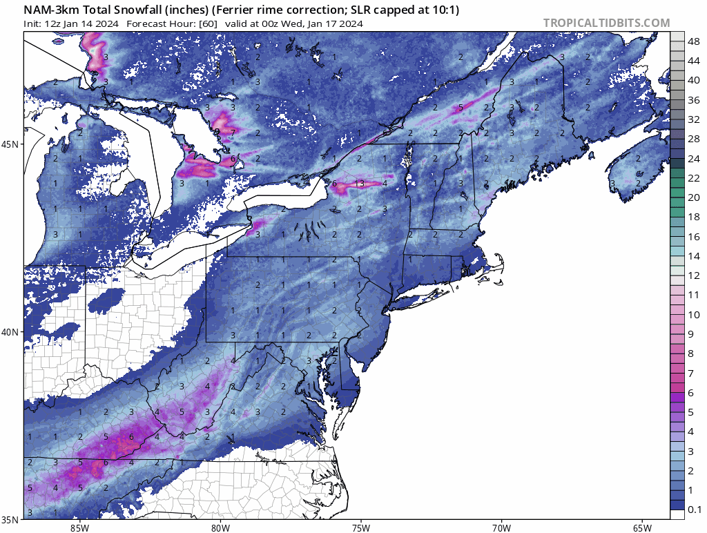
Agreed. While this could still potentially move further in the wrong direction (and to be clear, I think we'd be good for a while regardless), the NAM Nest is fine for snow for most of the area through the prime portion of the event. In fact, the "Ferrier" accumulation, which is completely driven by the model microphysics, has a nice accumulation for many, indicating that the model has the hydrometeors falling as snow for plenty of the key hours, even if it turns to some light freezing rain Tuesday morning: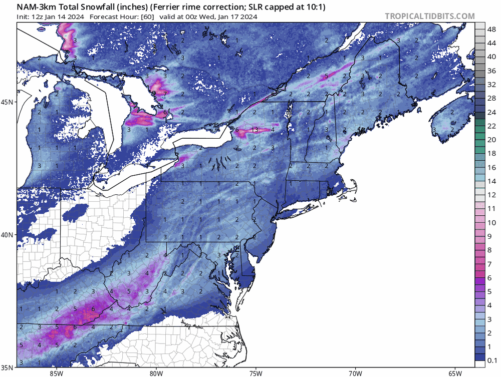
-
Jan 15-16 Storm Threat Thread: The Return of Hope??
high risk replied to stormtracker's topic in Mid Atlantic
The RRFS (Rapid Refresh Forecast System, a 3 km ensemble, is being developed. It hasn't been easy, because it has to be at least as good as the HREF to replace it, and it's far easier to get meaningful spread from a a system with multiple different models (HREF) than a system with just a single model core. -
Jan 15-16 Storm Threat Thread: The Return of Hope??
high risk replied to stormtracker's topic in Mid Atlantic
That's the key point. It's badly out of date and wasn't a great system when it was "in date". -
Jan 15-16 Storm Threat Thread: The Return of Hope??
high risk replied to stormtracker's topic in Mid Atlantic
YES -
Jan 15-16 Storm Threat Thread: The Return of Hope??
high risk replied to stormtracker's topic in Mid Atlantic
The main focus is on us getting NAM'ed, but I'll just make a quick point that this isn't really true. The SREF is a mix of 13 ARW and 13 NMMB runs using a mix of RAP, NAM, and GFS initial conditions (and multiple physics). Yes, half of the members have the same model core as the NAM, and roughly 1/3 use NAM initial conditions, but it's not a NAM ensemble. -
Jan 15-16 Storm Threat Thread: The Return of Hope??
high risk replied to stormtracker's topic in Mid Atlantic
Plus a heavy snow squall Sunday morning -
Jan 15-16 Storm Threat Thread: The Return of Hope??
high risk replied to stormtracker's topic in Mid Atlantic
This was discussed last night. It's not just the HRRR - every hi-res model has a line of snow squalls rolling through the area Sunday morning. Yeah, it might be rain drops for a few minutes, but it will quickly turn to a fun burst of snow. -
Jan 15-16 Storm Threat Thread: Do we finally win or get Saltburned?
high risk replied to H2O's topic in Mid Atlantic
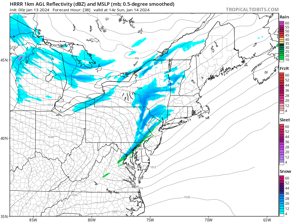
The NAM Nest, HRRR, and FV3 and ARW2 HiRes Windows all joined the "narrow line of snow squalls on the arctic front" party for Sunday morning. Great signal! Example from the HRRR:
- 425 replies
-
- 15
-

-
- jinx
- kiss of death
- (and 3 more)
-
Jan Medium/Long Range Disco 2: Total Obliteration is Coming
high risk replied to Jebman's topic in Mid Atlantic
For clarification, I just want to note that the NBM is not a model like the GFS, HRRR.... It's the National Blend of Models which blends and calibrates guidance from actual models. It accounts for the solutions among deterministic runs and ensemble members from numerous modeling systems around the world and is designed to capture signals of consensus. So, it's pretty nice to see it show a healthy signal for next week at this range. -
Watching that line build over northern VA. It's easy to ignore it given the huge swath of intense rain departing to the east, but if you look closely at the CAMs, there are signals for some isolated heavy cells moving across the area over the next 3-4 hours. Temperatures should rise ahead of it, and there is a little bit of progged instability..... Curious to see if these things are anything more than brief heavy rainers.
-
The point, though, is that the heaviest rain and flooding potential are indicated by all guidance to arrive after schools would have dismissed at the regular time (and bus routes would have ended).
-
I'm not seeing the big wind threat for most of the area (except southern sections and areas along the Bay) until dinner time and especially later. Temperatures will be slow to rise tomorrow; I think we have to get into the low to mid 50s before we can really mix, and that's not going to happen until much later in the day or early evening.
-
Looking forward to seeing what this looks like on the NAM Nest once we get into range.
-
The 12 km NAM has a nice depiction of the intense, forced rain band that will accompany the front later Tuesday evening. This will potentially be our greatest chance to mix some of the stronger winds just above the surface down to the ground. I'm very modestly hopeful of hearing thunder.
-
For future reference, that's the 12 km NAM, as also known as the parent. The 3 km NAM Nest is usually labeled as either the 3km or the nest.
-
Totally agree about the low-level temps. The EC and Canadian bring much of the I-95 corridor into the upper 30s by Saturday evening, but the NAMs this evening keep that area around 33. With the north-northeast wind direction shown on most guidance, a quick rise into the upper 30s while precip is falling seems unlikely.
-
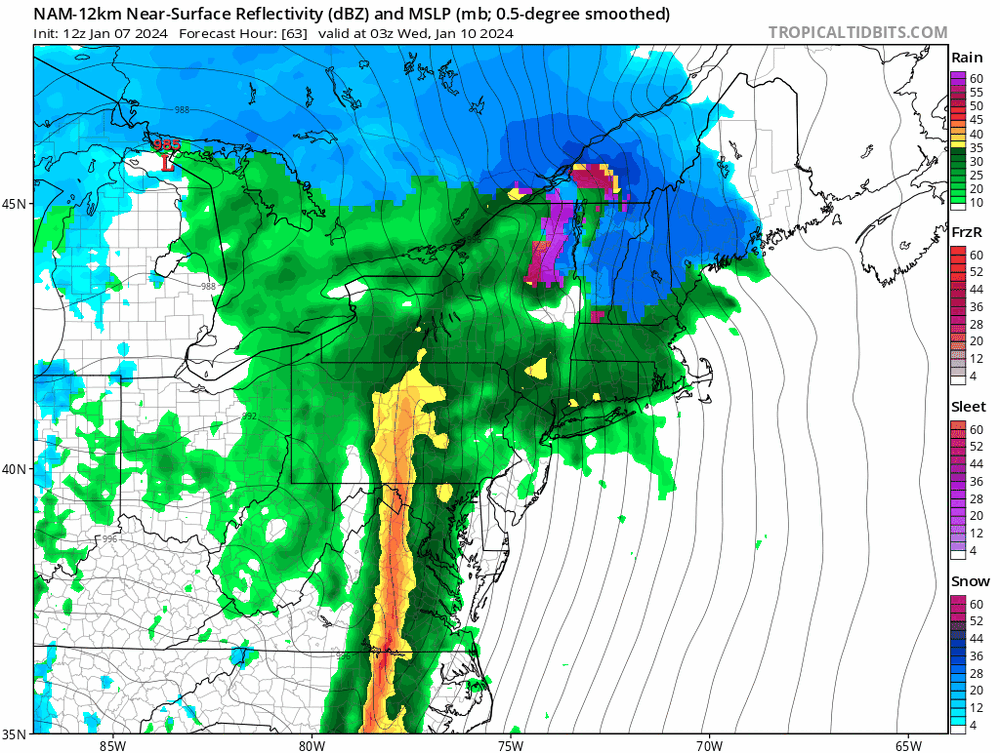
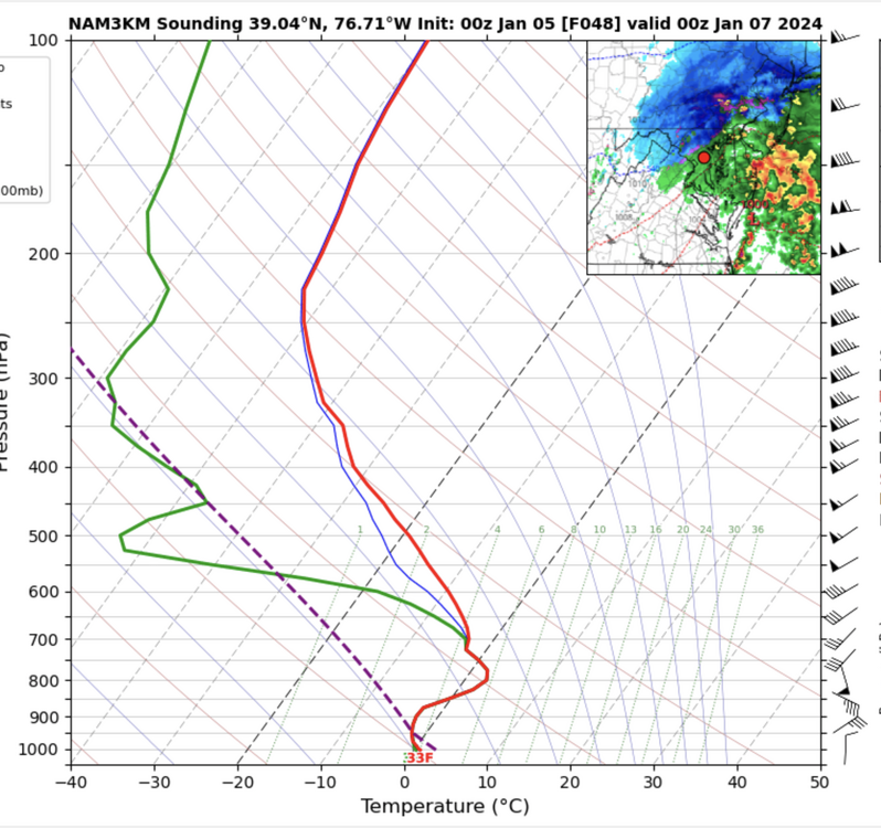
The NAM 10:1 maps look huge even along the I-95 corridor, because even after the precip type maps show rain, the model microphysics are generating sleet which is going into the snow water equivalent tally.. Here is a sounding from the "rain" area: That's heavy sleet. Not saying that the thermal profile will be correct, but it explains the generous 10:1 totals.
-
That's fair. The depth field is underdone in events with warm ground going in, marginal temps, and good rates. But it's a strong alternative to 10:1 maps when you have a lot of sleet (or other mix) or poor rates with marginal temps. In events that argue for rates overcoming temps, a blend of the 10:1 and snow depth, with a solid lean towards the depth, often works well.
-
Thanks for this example! WB must be making their own determinations about how much QPF is going into each precip type. As I mentioned, the only "accounting" in the actual models (RAP/HRRR excluded) is a snow water equivalent bucket that counts whatever fraction of the falling precip is snow or sleet. It's "good" in that the WB approach wipes out the sleet and also the accumulations when the profile doesn't support pure snow, but they're trying to match precip the accumulates over a longer period of time with the instantaneous precip type, so that won't always work very well. Ultimately, the RAP/HRRR do things the right way: they have separate buckets for each precip type and output each of them. It removes the guesswork. This approach will be used in the new RRFS, and the GFS is going to adopt it too.
-
Assuming you're talking about 10:1 maps? That's really odd, as the models generate a water equivalent of snow field in mm that should simply be converted to inches and multiplied by 10. The only thing that they could be doing is trying to make their own determinations about how much of a period of QPF is snow, but that would involve a lot of assumptions on their end that would not work well. I'd be very interested in seeing an example.
-
Good to see you here @usedtobe! I'm also a huge proponent of the snow depth product in these marginal temperature events, but I like to throw in the caveat that it will be underdone in these type of events if the rates are really good.