

high risk
-
Posts
3,241 -
Joined
-
Last visited
Content Type
Profiles
Blogs
Forums
American Weather
Media Demo
Store
Gallery
Everything posted by high risk
-
NAM and GFS now both have the idea of a backdoor front on Sunday lying somewhere across the region, with 80's in Richmond and 50s in Frederick, and uncertainly on which side of the boundary DC lies. Canadian has the boundary much further north. Waiting to see the Euro.
-
Thinking we have a good shot to see 80s either by Friday or Saturday
-
pretty model good agreement for a heavy line of showers (maybe some isolated thunder) sweeping across the area late this afternoon / early evening, intensifying as it approaches the Potomac
-
And the Canadian ensemble mean + the GFS and GEFS + the Euro and Euro ensembles say we'll be in the 70s that day, with some of the deterministic solutions pushing 80.
-
With Philippe now increasingly likely to track into far eastern New England, guidance is trending towards a much windier weekend here than initially expected.
-
 Thunder in southern Howard County!
 -
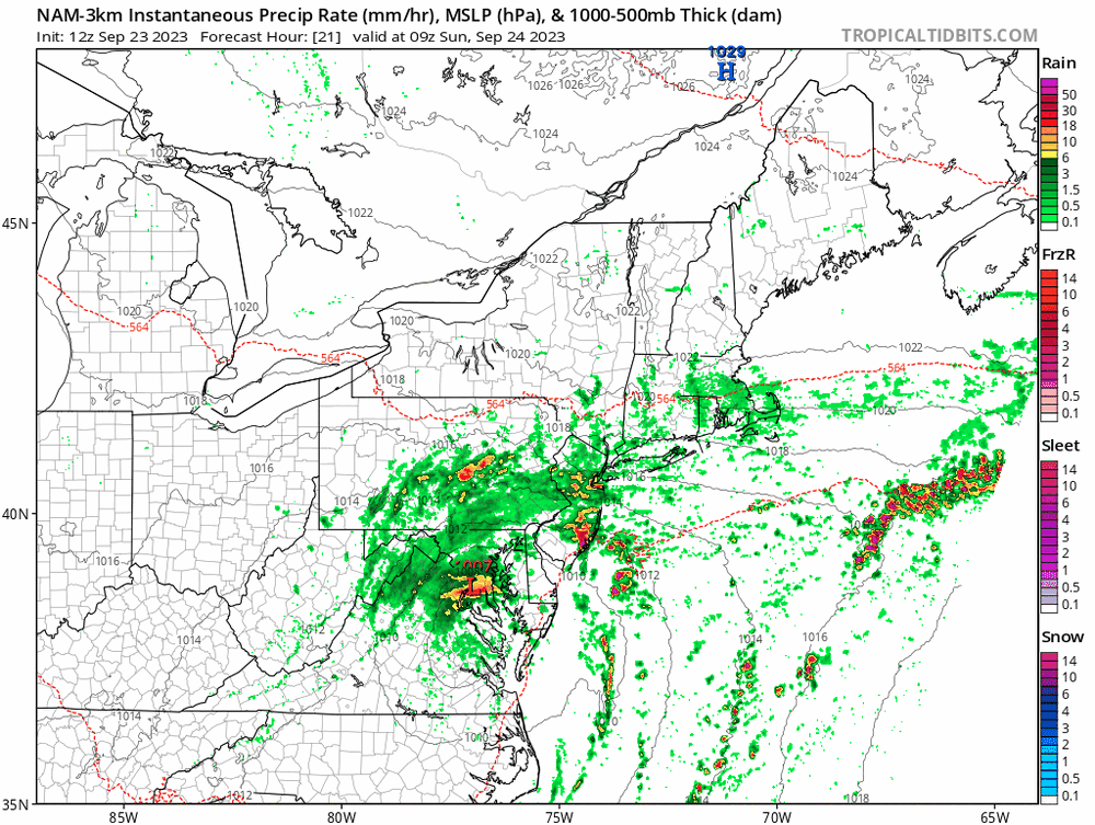
Exactly! We're right where we are supposed to be in terms of rainfall through mid-morning. Another round of heavier rain is clearly approaching from the southeast now, with more bands later today. I think that the time to really watch is late tonight and early Sunday. Remnant tropical systems often overperform big-time with rains close to the center during the night. Several consecutive runs of the NAM Nest show this idea:
- 563 replies
-
- 11
-

-
Sunday starting to look like a cloudy, chilly, and potentially wet day.
-
2023 Mid-Atlantic Severe Wx Thread (General Discussion)
high risk replied to Kmlwx's topic in Mid Atlantic
Realizing that you're just sharing info, I don't understand #2. The HREF is just means and probabilities generated from all of the operational CAMs. So, it can't be dramatically different from its inputs. -
A lot of CAM guidance this evening showing very early storms Sunday on the east side of the Potomac with new cells firing around DC Metro by midday.
-
2023 Mid-Atlantic Severe Wx Thread (General Discussion)
high risk replied to Kmlwx's topic in Mid Atlantic
Seems to be some pretty good agreement among the CAMs that the best chance of storms early tomorrow evening is over north and north-central MD.- 2,785 replies
-
- 2
-
-
- severe
- thunderstorms
- (and 3 more)
-
2023 Mid-Atlantic Severe Wx Thread (General Discussion)
high risk replied to Kmlwx's topic in Mid Atlantic
And of course SPC issues a SLGT right after I type that.....- 2,785 replies
-
- 6
-

-
-
- severe
- thunderstorms
- (and 3 more)
-
2023 Mid-Atlantic Severe Wx Thread (General Discussion)
high risk replied to Kmlwx's topic in Mid Atlantic
Yes, but it's progged to split and then shear out a lot tomorrow as it comes east. Instability will be good, and there may be just enough shear for a few organized cells with some wind potential, but it sure doesn't look like a big day. Hell, I'm thrilled just to have a threat of convection again.- 2,785 replies
-
- 1
-
-
- severe
- thunderstorms
- (and 3 more)
-
2023 Mid-Atlantic Severe Wx Thread (General Discussion)
high risk replied to Kmlwx's topic in Mid Atlantic
classic playbook here: MCS dies on approach in the early morning hours but limits heating for the late afternoon show- 2,785 replies
-
- 6
-
-
- severe
- thunderstorms
- (and 3 more)
-
2023 Mid-Atlantic Severe Wx Thread (General Discussion)
high risk replied to Kmlwx's topic in Mid Atlantic
That's for the afternoon cells. The morning MCS would be "regular" thunderstorms, but I hope it plays out. It's going to be an MCS party for the next 36 hours in the Mid-Atlantic - just a question of who gets invited.- 2,785 replies
-
- 4
-
-
- severe
- thunderstorms
- (and 3 more)
-
2023 Mid-Atlantic Severe Wx Thread (General Discussion)
high risk replied to Kmlwx's topic in Mid Atlantic
The flood watch was absolutely justified, but due to the PWATS and existing wet ground. The storm motions off of the 12Z IAD raob were faster than 30 mph. The severe box was less justified. It verified well due to a bunch of reports at the far southern end, but most of the box was lacking in reports. -
2023 Mid-Atlantic Severe Wx Thread (General Discussion)
high risk replied to Kmlwx's topic in Mid Atlantic
I'm not sure that it's that sneaky if it's covered by an SPC 5% TOR risk. But yes, the shear is good and getting stronger, and forcing is arriving. The only question is whether the storms can root into the boundary layer. I'd say that's quite uncertain.- 2,785 replies
-
- 1
-
-
- severe
- thunderstorms
- (and 3 more)
-
2023 Mid-Atlantic Severe Wx Thread (General Discussion)
high risk replied to Kmlwx's topic in Mid Atlantic
The question is does the instability get swept off to the east by the approaching cold front before storms can initiate. The evening guidance now seems to be in fairly good agreement that storms will initiate along and maybe even slightly west of the 95 corridor by early afternoon. Even though the best chance of organized severe will be further east (and I'm talking DC, as northeast MD is in a good spot), the shear along the I-95 corridor might support splitting supercells. -
2023 Mid-Atlantic Severe Wx Thread (General Discussion)
high risk replied to Kmlwx's topic in Mid Atlantic
Agreed. And it should be rotating - the wind profiles definitely favor rotation, and the profiles are stronger to the east and northeast of those cells. I just wonder if it's rooted above the boundary layer. Would not be surprised if an MD came out for northern MD / southern PA at some point in the next couple of hours. -
2023 Mid-Atlantic Severe Wx Thread (General Discussion)
high risk replied to Kmlwx's topic in Mid Atlantic
The HRRR has been pretty consistent keeping the overnight activity north of the DC area, and storms are starting to fire now in northeastern WV. The shear tonight supports a tornado threat; it's just unclear whether the storms will be surface-based.- 2,785 replies
-
- 2
-
-
- severe
- thunderstorms
- (and 3 more)
-
2023 Mid-Atlantic Severe Wx Thread (General Discussion)
high risk replied to Kmlwx's topic in Mid Atlantic
There will be no upgrades to the HRRR since it's slated for retirement.- 2,785 replies
-
- 2
-
-
- severe
- thunderstorms
- (and 3 more)
-
2023 Mid-Atlantic Severe Wx Thread (General Discussion)
high risk replied to Kmlwx's topic in Mid Atlantic
That's mostly how I see it too. I'll disagree on round 1 being "weak" - the HRRR simulated reflectivities are fine; isolated SVR seems likely, but I question the TOR threat with the weaker low-level winds. Shear cranks up after dark, but we'll be fighting decreasing instability. To me, the biggest potential overlap between increasing shear and still-sufficient sfc-based instability will be northwest of the DC area.- 2,785 replies
-
- 1
-

-
- severe
- thunderstorms
- (and 3 more)
-
2023 Mid-Atlantic Severe Wx Thread (General Discussion)
high risk replied to Kmlwx's topic in Mid Atlantic
Looking at the 00Z CAMs, I'd put the Monday TOR threat as an SPC 2% area instead of 5 for the local area due to weak low-level winds and limited storm coverage. The bigger TOR threat might be western MD and adjacent parts of WV/PA in the early evening. There are also some timing differences for Tuesday. HRRR would require that the SLGT area be extended back west of DC, but it seems like an outlier for now.- 2,785 replies
-
- 2
-
-
- severe
- thunderstorms
- (and 3 more)
-
2023 Mid-Atlantic Severe Wx Thread (General Discussion)
high risk replied to Kmlwx's topic in Mid Atlantic
The 5% makes sense, given the southeasterly low-level winds progged by all guidance. What's keeping us from a higher threat is fairly weak surface wind speeds as well as lower speeds in the 900-700 mb level. If the low-level wind fields end up stronger, we would have more significant TOR potential.- 2,785 replies
-
- 5
-
-
- severe
- thunderstorms
- (and 3 more)
-
2023 Mid-Atlantic Severe Wx Thread (General Discussion)
high risk replied to Kmlwx's topic in Mid Atlantic
I'm out of town tomorrow, so LOCK IT IN.- 2,785 replies
-
- 3
-
-
-
- severe
- thunderstorms
- (and 3 more)
