

high risk
-
Posts
3,231 -
Joined
-
Last visited
Content Type
Profiles
Blogs
Forums
American Weather
Media Demo
Store
Gallery
Everything posted by high risk
-
Do you have an example? The 10:1 maps should be the same everywhere. The snow depth maps should be too, except that while Tropical Tidbits only counts positive changes in depth (i.e. they ignore when the amount goes down due to melting or compacting), while others may count any change. Even the Kuchera method should, in theory, yield the same result across sites.
-
That's because the code that accumulates snow is inside the model and is driven by microphysics, and the code that generates precip type is outside of the model and is driven (mostly) by the temperature profiles.
-
Now would be a good time for a few quick reminders about model snow accumulations: - Most of the American models (I'm not entirely sure about our international friends) generate a water equivalent of snow. It's then up to the user to apply a reasonable snow-to-liquid ratio. Some sites compute one (i.e. Kuchera), but that tends to be somewhat generous. 10:1 is the most commonly displayed field, but while it's a nice one-size-fits-all approach, it's not always applicable to the temperature profile. The key here is that if you're looking at a GFS 10:1 map in a marginal temperature situation, don't say that the GFS shows 6-8 or whatever amount. It doesn't. Mentally adjust that "starter map" as needed. - Along those lines, the water equivalent of snow is not always a measure of how much snow can accumulate. Sleet goes into the same bucket as snow, so an all sleet event will still show large water equivalents, and a 10:1 map looks absurd. Even an event with 1" of liquid that consists of a 50-50 mix of rain and mangled snowflakes will show 0.5" of snow water equivalent. If you use a 10:1 map, you get 5", even though the model never really thought that anything would stick. - Those issues with sleet or snow that won't accumulate due to warm ground or marginal temps are largely handled by the snow depth field which is the actual amount that the model thinks will be on the ground. 10:1 and snow depth maps look amazingly different in sleet events, as they should. But they also often look different in events with marginal temps or very warm ground. The snow depth maps are usually good, but they do tend to underestimate when the ground is quite warm heading into an event or if big rates overcome marginal temps. In those events, a blend of the 10:1 and snow depth maps is often a good call. - RAP/HRRR actually predicts accumulations (with a temperature-dependent SLR) that account for compacting and melting, although they're not displayed on Tropical Tidbits. - The NBM computes SLRs for each member with snow, and the system overall uses a lot of inputs (including ensembles) and is calibrated, so it's worth a look. Remember, though, that it won't respond immediately to big shifts in guidance. Knowing the limitations of the products you're examining helps to limit the confusion, frustration, and ugly analysis. Thanks for coming to my TED talk.
-

Jan Medium/Long Range Disco: Winter is coming
high risk replied to stormtracker's topic in Mid Atlantic
The last GEFS upgrade (Fall 2020) switched the system to the FV3 model core and among many improvements, the spread was increased (as intended), and the extra spread was largely meaningful spread. That said, the GFS had a fairly significant upgrade (to version 16) after the GEFS upgrade, and the GEFS has not received the corresponding update. Overall, it still feels to me like the GEFS responds to GFS trends more than it should, consistent with the observation by@WxUSAF that there seems to be an element of follow the leader. -
Jan Medium/Long Range Disco: Winter is coming
high risk replied to stormtracker's topic in Mid Atlantic
GFS temps are at or above freezing for a good chunk of the event. Snow of course can absolutely accumulate at those temps with good rates, particularly if it falls after dark Saturday night, but 10:1 is likely to be too high for the SLR. -
This isn't how standard NWP works. Historical data plays no role: you have equations that represent all relevant processes, you create an initial state based on observations, and you integrate the model. Historical data *does* factor in for AI/ML approaches, but if you're just looking at a standard GFS forecast map, it doesn't know anything about years past.
-
Worth noting that the two CAMs that are run to 60 hours (NAM Nest and HiResWindow FV3) both show a burst of snow showers very early Tuesday for those of us on the east side of the Potomac.
-
The GEFS was indeed upgraded to use the FV3 core in 2020! https://www.emc.ncep.noaa.gov/users/meg/gefsv12/ It doesn't, however, have the changes that were made to the GFS in Version 16 in 2021.
-
Before midnight? I guess it depends how you define "many of us NW of 95", but it looks to me to show that occurring just after midnight. The HREF is just averaging the HRRR, NAM Nest, and Hires Windows - the most recent 2 cycles of each.
-
Yeah, I'm the biggest advocate for the depth maps for events with warm ground and marginal temps, but those maps can run low IF the rates are legit (and it helps if the snow falls at night)
-
NDFD is the gridded NWS forecast
-
I'll chime in, the answers (opinions??) are complicated and nuanced. The HRRR is still the flagship CAM, but it has primarily been tuned for deep convection, and I hesitate to use it much for winter weather, especially with cold air damming events. The HRRR also hasn't been updated in way too long, because all efforts are on RRFS, which hasn't come together as quickly as planned. The NAM Nest, IMHO, is still very good for precip type, although it runs a bit on the cold side and is wet, but there isn't currently a CAM that does better with cold air damming. There are 3 HiRes Windows (ARW, ARW2, and FV3) - they are all operational, but I don't love them for winter weather. The FV3 HiRes Window is particularly bad for thermal profiles. If I had to pick a CAM for winter, I'd go with the NAM Nest, but I'd be weary of its synoptic errors beyond 36-48 hours and realize that it runs a bit on the cold side.
-
If we're talking about Northern Hemisphere Day 5 anomaly coefficient at 500 mb, which is generally considered the standard metric for synoptic performance, the GFS has been solidly in 4th place for most of this year, trailing the ECMWF, UKMET, and CMC.
-
For the love of God, please stop showing the 10:1 maps. This type of event with marginal temps and warm ground screams for the positive snow depth product.
-
It's really tough to ignore how similar the ECMWF and Canadian are for Halloween.
-
NAM and GFS now both have the idea of a backdoor front on Sunday lying somewhere across the region, with 80's in Richmond and 50s in Frederick, and uncertainly on which side of the boundary DC lies. Canadian has the boundary much further north. Waiting to see the Euro.
-
Thinking we have a good shot to see 80s either by Friday or Saturday
-
pretty model good agreement for a heavy line of showers (maybe some isolated thunder) sweeping across the area late this afternoon / early evening, intensifying as it approaches the Potomac
-
And the Canadian ensemble mean + the GFS and GEFS + the Euro and Euro ensembles say we'll be in the 70s that day, with some of the deterministic solutions pushing 80.
-
With Philippe now increasingly likely to track into far eastern New England, guidance is trending towards a much windier weekend here than initially expected.
-
Thunder in southern Howard County!
-
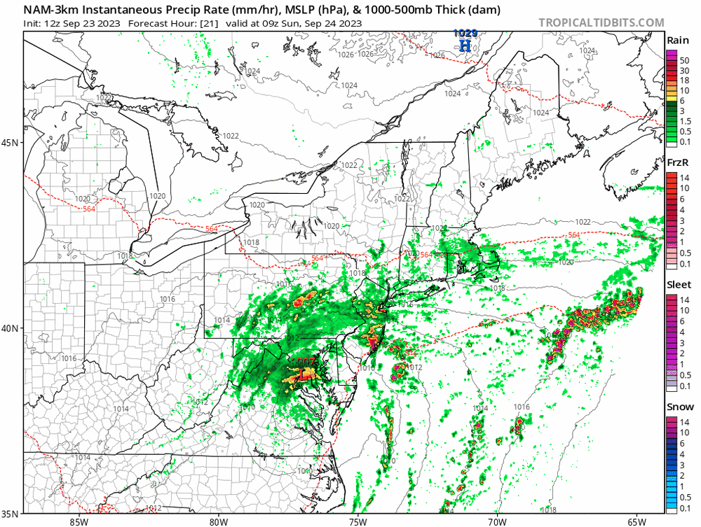
Exactly! We're right where we are supposed to be in terms of rainfall through mid-morning. Another round of heavier rain is clearly approaching from the southeast now, with more bands later today. I think that the time to really watch is late tonight and early Sunday. Remnant tropical systems often overperform big-time with rains close to the center during the night. Several consecutive runs of the NAM Nest show this idea:
- 563 replies
-
- 11
-

-
Sunday starting to look like a cloudy, chilly, and potentially wet day.
-
2023 Mid-Atlantic Severe Wx Thread (General Discussion)
high risk replied to Kmlwx's topic in Mid Atlantic
Realizing that you're just sharing info, I don't understand #2. The HREF is just means and probabilities generated from all of the operational CAMs. So, it can't be dramatically different from its inputs. -
A lot of CAM guidance this evening showing very early storms Sunday on the east side of the Potomac with new cells firing around DC Metro by midday.


