high risk
-
Posts
3,231 -
Joined
-
Last visited
Content Type
Profiles
Blogs
Forums
American Weather
Media Demo
Store
Gallery
Everything posted by high risk
-
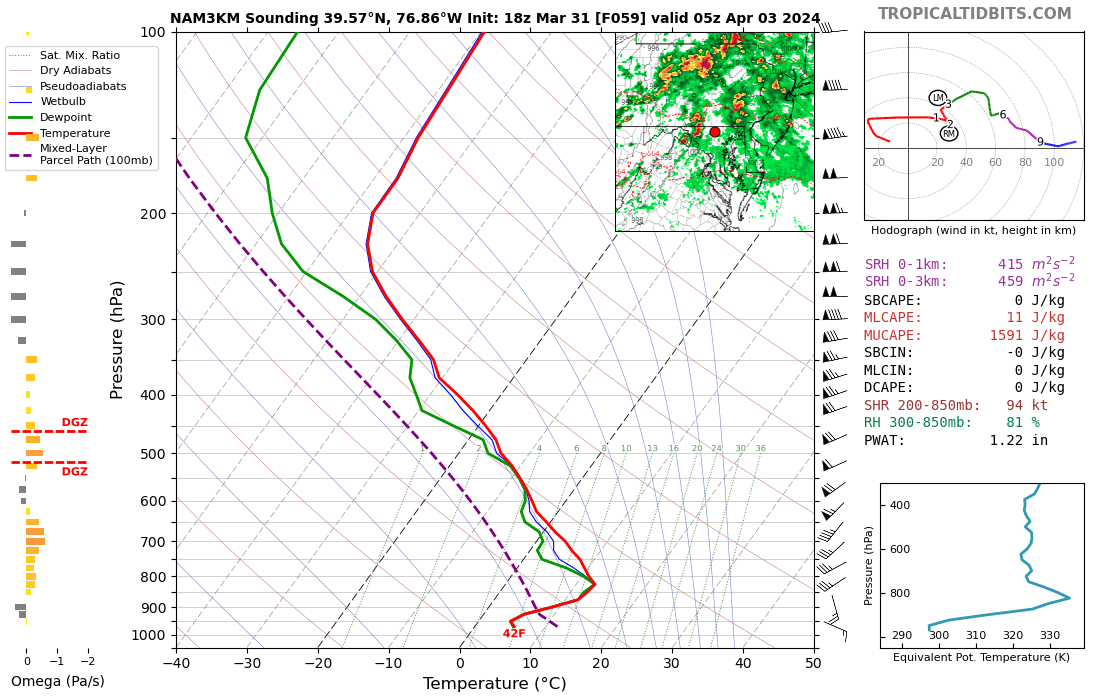
Returned from a vacation and saw that we're going to be wedged on Tuesday with the front well south of here, so I was shocked to see that we're in a Day 3 SLGT. All of the skepticism is of course warranted, as we don't do SVR here with elevated convection well at all. That said, though, the lapse rates look shockingly impressive above the stable surface layer Tuesday evening or night, so maybe this is one of those super rare instances where we can get some decent hail even when temps at the ground are in the 40s. Again, this type of setup is so difficult to make work in the Mid-Atlantic, but we don't often see 1500 of elevated CAPE. .

- 1,696 replies
-
- 6
-

-
- severe
- thunderstorms
- (and 5 more)
-
This is what I was saying, based on the forecasted soundings. If you start a parcel around 700 mb (710, to be precise, per the diagnostics), you do have some actual CAPE. It's just rare here to get convection based that high. The April 2011 comparison you made is likely a really good one.
-
I remember that event. The lightning was incredible.
-
For sure. There is a stout low-level inversion which is perfect for getting those loud rolling rumbles.
-
Very bizarre. The model soundings certainly don't suggest thunder, unless you lift a parcel from up around 700 mb, and that's rarely a path to thunder here.
-

The Weekend Rule? Saturday 2/17 - The Icon Storm
high risk replied to DDweatherman's topic in Mid Atlantic
For snow. Jesus, I'm gonna get fired. -
The Weekend Rule? Saturday 2/17 - The Icon Storm
high risk replied to DDweatherman's topic in Mid Atlantic
There are many times when the accumulated snow depth product should be examined, but it hates events with marginal temps and big rates like this one. -
2024 Valentines Day Who the Hell Knows - Comeback Thread
high risk replied to DDweatherman's topic in Mid Atlantic
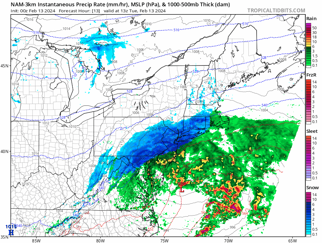
The details weren't perfect, and it wasn't consistent run-to-run, but some of the NAM Nest runs yesterday did have some handle on the dry slot: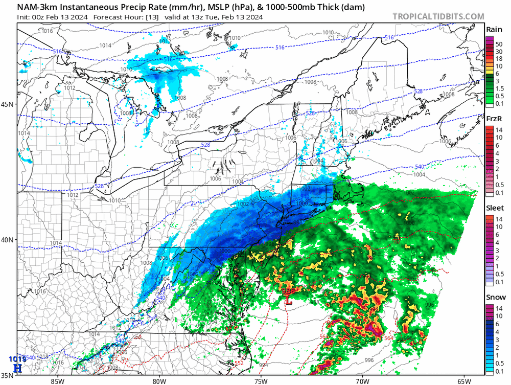
-
2024 Valentines Day Who the Hell Knows - Comeback Thread
high risk replied to DDweatherman's topic in Mid Atlantic
I was mostly speaking in jest, but 1) 10:1 maps are not good for interpreting model snowfall in events like these 2) I'm still troubled by the NAM Nest not showing much here. Maybe it will cave at 00Z, but it has a good track record in events like these at shorter ranges. -
2024 Valentines Day Who the Hell Knows - Comeback Thread
high risk replied to DDweatherman's topic in Mid Atlantic
Goddamnit, y'all. I have literally worked as a RAP/HRRR developer, and I would still use the JMA or NAVGEM before I used the RAP/HRRR system for snow amounts. -
2024 Valentines Day Who the Hell Knows - Comeback Thread
high risk replied to DDweatherman's topic in Mid Atlantic
minor addendum: it's still very much experimental and is not scheduled for implementation now until 2025 -
2024 Valentines Day Who the Hell Knows - Comeback Thread
high risk replied to DDweatherman's topic in Mid Atlantic
It's not the kiss of death, but major red flags should always be raised with regards to accepting a 12 km NAM solution when its 3 km nest shows something different. -
2024 Valentines Day Rain/Snow/Who The Hell Knows Thread
high risk replied to WinterWxLuvr's topic in Mid Atlantic
It always warms my heart to see the snow depth maps posted here, but this is not the type of event for which they do well. They limit accumulation when surface temps and soil are warm, and they'll never capture the ability of heavy rates to overcome marginal thermodynamics. I'd probably either average the 10:1 and snow depth products or mentally adjust the 10:1 maps downward. Kuchera maps might be good too - I hate how generous they are with colder temps, but they seem to properly limit accumulations when the temperature is marginal.- 563 replies
-
- 11
-
-

-
bright banding??
-
Jan 19th Snow on Snow: the this always works until it doesn't thread
high risk replied to psuhoffman's topic in Mid Atlantic
I'll take a few of those convective bursts of snow at the end of the event, please.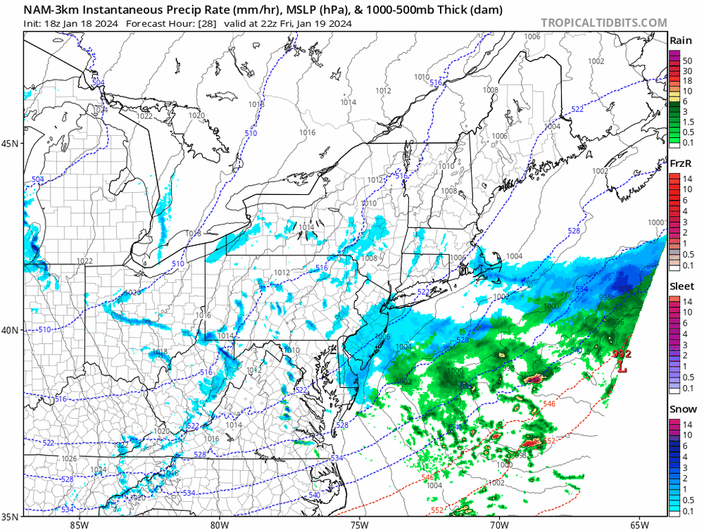
- 824 replies
-
- 18
-
-
Jan 19th Snow on Snow: the this always works until it doesn't thread
high risk replied to psuhoffman's topic in Mid Atlantic
I don't think that this is a storm for which the super generous Kuchera ratios will work well. It's not super cold, and lift does not appear to be maximized in the DGZ. With cold ground and temps a few degrees below freezing, this might be one of those cases in which the 10:1 maps actually work pretty well. -
Jan 18-19 Storm Threat: Bob Chill made me do it
high risk replied to stormtracker's topic in Mid Atlantic
One other thing, and perhaps I missed discussion of this: a few CAMs and the GFS show a period of light snow here Thursday evening with the lead wave. -
Jan 18-19 Storm Threat: Bob Chill made me do it
high risk replied to stormtracker's topic in Mid Atlantic
Surface temperatures are super marginal, so it might have some difficulty sticking on roads once we get past 8am or so. That said, the road surfaces should be plenty cold going into the event, so rates might still get the job done. -
Nice! I don't have that sort of precision on my station, but it is showing 6 this morning.
-
Jan 18-19 Storm Threat: Bob Chill made me do it
high risk replied to stormtracker's topic in Mid Atlantic
The 12 km parent and 3 km nest have different diffusion, so differences in 500 evolution can and do happen. -
Jan 18-19 Storm Threat: Bob Chill made me do it
high risk replied to stormtracker's topic in Mid Atlantic
The northward shift in that run also makes us a bit warmer at the surface, which reduces the ability of the snow to stick during the daytime hours, although surfaces at least will overall be cold. -
Jan 18-19 Storm Threat: Bob Chill made me do it
high risk replied to stormtracker's topic in Mid Atlantic
correction: The actual model run will run on time as it does 99% of the time. The TT graphics processing, run on a 1984 Commodore 64, will be ready by bedtime.- 684 replies
-
- 28
-

-
-
-
Depends whether they can clear all of the side streets and sidewalks today and give them time to dry out this afternoon before the temps plummet later. Anything that isn't dry will freeze hard tonight, so I would say that there could be delays or closings again tomorrow.
-
4" here in southern Howard County
-
Traffic maps across the region look far worse than I expected to see during the daylight hours on a holiday. Likely to look much worse when the sun sets and rates increase.