high risk
-
Posts
3,241 -
Joined
-
Last visited
Content Type
Profiles
Blogs
Forums
American Weather
Media Demo
Store
Gallery
Everything posted by high risk
-
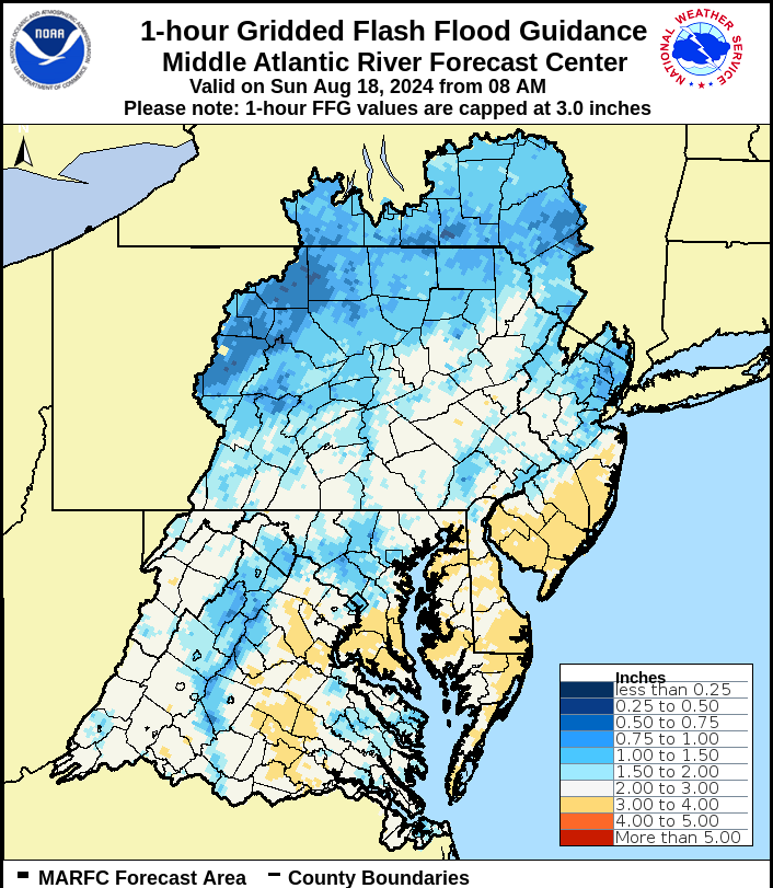
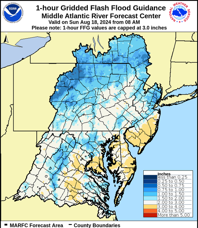
Would only take about 1" in an hour to cause problems in parts of the area, per flash flood guidance. That seems achievable, even if storms are progressive.
-
Can confirm that it's absolutely pouring in southern Howard County with a good amount of lightning
-
Also, a secondary cold front is passing through - the leading air of the truly drier air mass. Dew points were still in the upper 60s today.
-
Tomorrow will be better than it has been, but dew points may still be in the mid or upper 60s. A second front goes through Saturday evening (HRRR blows up a batch of showers), and then the real dry air arrives Saturday night.
-

Tropical Storm Debby: Mid-Atlantic Impacts
high risk replied to WxWatcher007's topic in Mid Atlantic
Over 2" at my place a few miles south of yours. -
Tropical Storm Debby: Mid-Atlantic Impacts
high risk replied to WxWatcher007's topic in Mid Atlantic
This band is the real deal in terms of rainfall. Lightning and thunder too. -
Tropical Storm Debby: Mid-Atlantic Impacts
high risk replied to WxWatcher007's topic in Mid Atlantic
Worth noting that the model gust products (at least for the American models, not sure about Euro) are showing a gust potential, not necessarily what will mix down. If there is high wind speed in the PBL, and it's ever so slightly unstable at the surface, it will mix a chunk of that momentum to the ground. I'm unconvinced that we'd mix efficiently in the tropical air mass, but I guess we'll see. -
Tropical Storm Debby: Mid-Atlantic Impacts
high risk replied to WxWatcher007's topic in Mid Atlantic
I'm not too concerned about winds, except for the EF-1 tornadoes on Friday. -
Tropical Storm Debby: Mid-Atlantic Impacts
high risk replied to WxWatcher007's topic in Mid Atlantic
I get what you're saying, with the seeming growing likelihood of the core synoptic rains shifting west, but there will be a multi-day period of very high PW values over the Mid-Atlantic with waves of scattered convection. There will absolutely be areas that get a ton of rain, and even some that will get a ton of rain before the "main day" on Friday. -
Tropical Storm Debby: Mid-Atlantic Impacts
high risk replied to WxWatcher007's topic in Mid Atlantic
Yeah, Friday will be a convective deluge in the warm sector. We'll see if the NAM is correct with the western track, although it does have the support of the Euro -
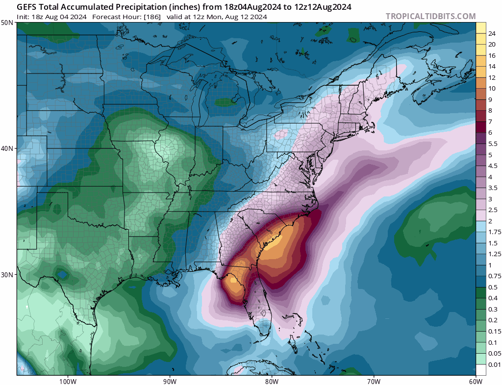
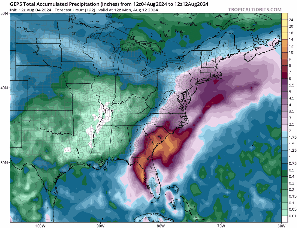
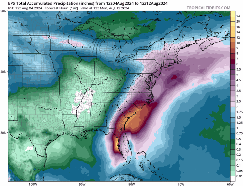
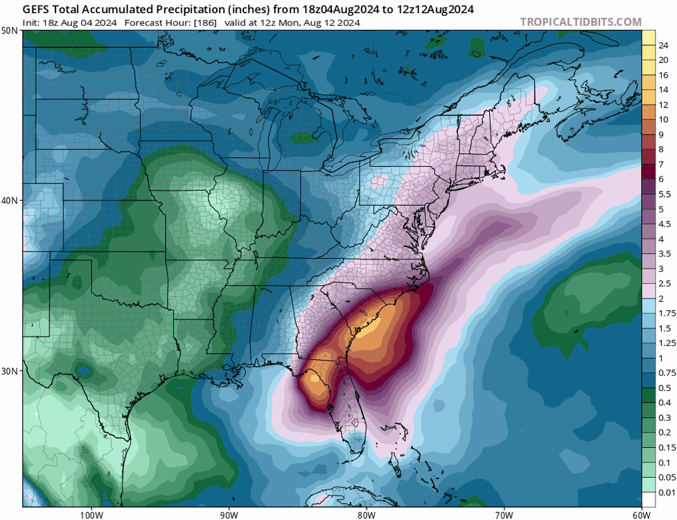
While the many individual members take multiple different paths to get there, the ensemble means for precipitation through the end of next weekend are all very wet for our area, without the east-west gradient seen in some recent deterministic solutions.
- 755 replies
-
- 13
-

-
Several CAMs have isolated moist blobs late Monday as well.
-
looks like perhaps an MRGL for Thursday
- 1,696 replies
-
- 5
-
-
- severe
- thunderstorms
- (and 5 more)
-
The signals there are encouraging for sure, and it's indicative of a chance of beneficial rains for a larger part of the area that's higher than we've seen in a while. The worry, though, is that these are the low-res models that aren't suited for capturing mesoscale details, and the CAMs show that despite what looks like a soaking for everyone in the global models, this will still be an event with winners and losers.
-
I wasn't paying attention to the location of that boundary at the time, but it's certainly possible in theory.
-
It's really getting its act together on the east side of DC, but that's far too late for those of us further west and northwest.
- 1,696 replies
-
- 2
-
-
- severe
- thunderstorms
- (and 5 more)
-
I'm pretty shocked by the lack of intensity and lack of lightning.
- 1,696 replies
-
- 2
-
-
- severe
- thunderstorms
- (and 5 more)
-
Absolutely. The HRRR is capturing the forcing and initiating convection, but because of the extreme issue with low-level drying, it can't possibly generate widespread, intense storms. This is the environment it has the storms moving into: With that low of a surface dew point, it can't possibly show impressive storms, but we all know that the actual dew point will be at least 5 degrees higher.
-
I understand questioning the watch, given the dry antecedent conditions, but I don’t understand the comment about most guidance giving us no rain. Toss the HRRR completely, because it’s doing its usual overmixing thing here and drops our dew points into the 50s this afternoon. The rest of the CAMs all have a heavy rain signal *somwhere* in the metro area and suggest a training scenario.
-
HRRR again reduces dew points into the upper 50s this afternoon. The fact that it's still able to generate a weak line in that environment certainly suggests that there will be forcing available to work with the "real" instability.
- 1,696 replies
-
- 4
-
-
- severe
- thunderstorms
- (and 5 more)
-
That midwest derecho won't make it here, but the CAM signal for widespread convection Wednesday in a fairly healthy environment is quite strong in this evening's runs. Would think we should wake up to a Day 2 SLGT in the morning.
- 1,696 replies
-
- 8
-
-
- severe
- thunderstorms
- (and 5 more)
-
This seems super unlucky. I got 0.35" from this evening's batch.
-
For sure. I think that western areas have the best chance of heavy Wednesday evening convection, and areas east have the best chance of the steadier Friday rain. That in-between zone along I-95 could get screwed on both (although we could “win” on either or both too).
-
Getting really concerned about trying to get meaningful rainfall this week. It’s still on the table, but it’s far from a sure thing, and lowering model QPF reflects that. It looks like 2 chances: 1) a line of convection on the front Wednesday evening which has potential for big localized totals, but will there be breaks in the line, and might it weaken if it arrives too late? 2) moisture moving from coastal areas back to the northwest Friday. The best rains will be east and southeast of us, but can we still get a modest soaking? Models now still have us within the “good” rain, but we’re getting dangerously close to the back edge, and any further shift east could really screw us. I wouldn’t want to be too far west of DC, as things currently look, for round 2.
-
Credit the CAMS which were hinting at a few showers developing along the front after dark. Heavy downpour in the Columbia/Ellicott City area.