high risk
-
Posts
3,241 -
Joined
-
Last visited
Content Type
Profiles
Blogs
Forums
American Weather
Media Demo
Store
Gallery
Everything posted by high risk
-

2023 Mid-Atlantic Severe Wx Thread (General Discussion)
high risk replied to Kmlwx's topic in Mid Atlantic
Very impressive signal. It forms a discrete cell out ahead of the main line in the early-mid afternoon when surface winds will be somewhat more backed, leading to a shear profile that would actually support some healthy rotation. But this is somewhat of an outlier solution.
-
2023 Mid-Atlantic Severe Wx Thread (General Discussion)
high risk replied to Kmlwx's topic in Mid Atlantic
Monday obviously has the higher end potential, but it looks like all of the CAMs have widespread afternoon convection on Tuesday. If you toss the NAM Nest low 70s dew points, the CAPE is modest in most solutions, and shear is weak, but there is a healthy amount of downdraft CAPE. I would think that the outlook for Tuesday will expand the MRGL back to the west over more of the area.- 2,785 replies
-
- 2
-

-
- severe
- thunderstorms
- (and 3 more)
-
2023 Mid-Atlantic Severe Wx Thread (General Discussion)
high risk replied to Kmlwx's topic in Mid Atlantic
not totally worthy of being mentioned in the severe thread, but for those of us who have been anxiously awaiting nocturnal convection, some of the CAMs say that at least several of us will be woken up later tonight by a round of storms. Radar is trying to light up a bit to our west.- 2,785 replies
-
- 4
-
-
- severe
- thunderstorms
- (and 3 more)
-
2023 Mid-Atlantic Severe Wx Thread (General Discussion)
high risk replied to Kmlwx's topic in Mid Atlantic
Is this really underwhelming? Maybe for western OH, but......
- 2,785 replies
-
- 3
-
-
- severe
- thunderstorms
- (and 3 more)
-
2023 Mid-Atlantic Severe Wx Thread (General Discussion)
high risk replied to Kmlwx's topic in Mid Atlantic
12Z CAMs are all over the place. Summary: NAM Nest FV3 HRRR ARW2 (for Howard County: ) ARW- 2,785 replies
-
- 9
-
-

-
- severe
- thunderstorms
- (and 3 more)
-
2023 Mid-Atlantic Severe Wx Thread (General Discussion)
high risk replied to Kmlwx's topic in Mid Atlantic
Yes, the NAM is typically too moist, but the HRRR absolutely overmixes.- 2,785 replies
-
- 2
-
-
- severe
- thunderstorms
- (and 3 more)
-
2023 Mid-Atlantic Severe Wx Thread (General Discussion)
high risk replied to Kmlwx's topic in Mid Atlantic
Definitely an overall very interesting 00Z suite. While there are still some valid questions about debris from Sunday convection and how the Monday storms evolve. I would think that much of the area wakes up tomorrow in a Day 2 SLGT. edit: I totally missed SPC updating the Day 3 to put us in a SLGT, so this post was pretty useless. I guess it's possible that parts of the area could get a Day 2 ENH, but the question marks listed might preclude that for now. -
2023 Mid-Atlantic Severe Wx Thread (General Discussion)
high risk replied to Kmlwx's topic in Mid Atlantic
I was surprised too. The 12z NAM Nest and HiResW FV3 definitely make the case for at least a SLGT. The CAPE is big-time Monday afternoon, timing of the forcing is ideal, and shear is decent, with even some modest low-level shear. Verbatim, the NAM Nest is a "south of I-70 show", while the FV3 lets northern areas get in on the show too.- 2,785 replies
-
- 4
-
-
- severe
- thunderstorms
- (and 3 more)
-
The Dover radar has been very misleading for us, but the nice looking band over eastern Howard County now is producing moderate rain.
-
2023 Mid-Atlantic Severe Wx Thread (General Discussion)
high risk replied to Kmlwx's topic in Mid Atlantic
That's what I'm getting at. The shear appears so far that it will be sufficient for severe, but with some pretty impressive analogs being tossed around, I would expect to see some much higher values.- 2,785 replies
-
- 1
-
-
- severe
- thunderstorms
- (and 3 more)
-
HRRR has been pretty consistent (with some support from other CAMs too) about some heavy showers mainly on the east side of the Potomac later tonight.
-
2023 Mid-Atlantic Severe Wx Thread (General Discussion)
high risk replied to Kmlwx's topic in Mid Atlantic
I had doubts about the timing of the system, but there seems to be some increasing agreement on better timing. The wind fields overall still don't look great, but it's impossible to ignore several impressive ingredients that may be in place.- 2,785 replies
-
- 3
-
-
- severe
- thunderstorms
- (and 3 more)
-
Wednesday is the synoptic rain, but it looks to go more convective on Thursday and beyond. With PW values progged to exceed 2" for multiple days, it certainly seems like at least isolated instances of high QPF totals and flash flooding will occur, even if the areal-averaged QPF amounts don't suggest the threat.
-
2023 Mid-Atlantic Severe Wx Thread (General Discussion)
high risk replied to Kmlwx's topic in Mid Atlantic
Tomorrow is a low overcast, seasonably chilly day with steady rain arriving - there isn't even a hint of instabilty. Agree that convective chances increase Thursday and ramp up further Friday. -
Tonight's GFS and CMC have it here now on Wednesday. Really hope this is legit.
-
The HRRR has been quite emphatic that this morning line would crap out as it arrived (with redevelopment to our east-northeast); it still really likes the idea of a more significant round 2 later this afternoon (although it verbatim screws the crew along I-70).
-
The question now is whether there is a modest line at the end of the "event" during the latter part of the rush hour. HRRR still says yes, but it's hard to have confidence in the idea.
-
That's not happening tomorrow, but I am hopeful of potentially 2 rounds of convection: one perhaps mid-morning or midday and another late. The 00Z WRF-ARW2 perhaps shows this idea the best. Unfortunately, there is enough "bad look" in some of the other CAMs to make me think that not everyone is going to cash in.
-
2023 Mid-Atlantic Severe Wx Thread (General Discussion)
high risk replied to Kmlwx's topic in Mid Atlantic
I totally hear you on this, but I think there are 2 different types of "speeding up" with convection here. There is the synoptic speed up, where the timing of the front and associated forcing end up arriving earlier, and things erupt on the other side of the Bay. Then there is the speed up of just the actual propagating convection itself - the front is handled well and all, but the line perhaps initiates slightly earlier than progged and then moves east faster.- 2,785 replies
-
- 3
-
-
- severe
- thunderstorms
- (and 3 more)
-
The 100 PoP in my NWS point-n-click forecast for tomorrow is..... brave.
-
2023 Mid-Atlantic Severe Wx Thread (General Discussion)
high risk replied to Kmlwx's topic in Mid Atlantic
Day 3 MRGL is east of here, but the 12Z NAM Nest an HiResW FV3 have slower timing of the front, so convection is better timed for much more of the area. Lapse rates are iffy, but shear is workable. If this trend continues, Day 2 products issued tomorrow would move the MRGL back into our area. Let's get the timing first. Then we can work on upgrading the environment to make it to SLGT.- 2,785 replies
-
- 3
-
-
- severe
- thunderstorms
- (and 3 more)
-
So far, yesterday's HRRR smoke output does not not appear to have a good handle on today.
-
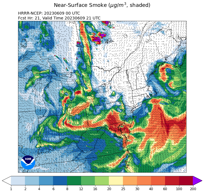
Curious as to why you would say that. HRRR has been pretty consistently showing some pretty substantial low-level smoke concentrations persisting through tomorrow. 00Z cycle this evening 21h forecast valid later Friday afternoon:
-
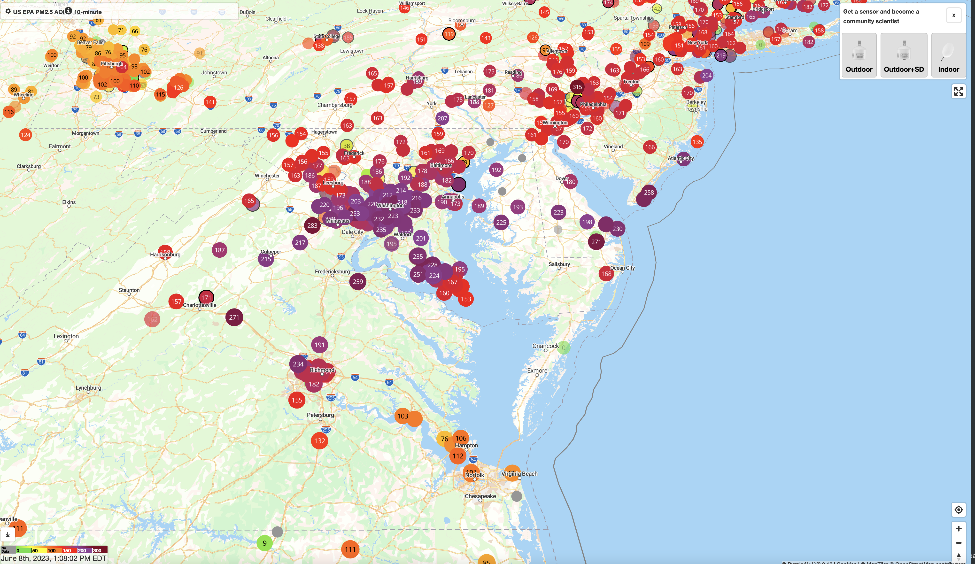
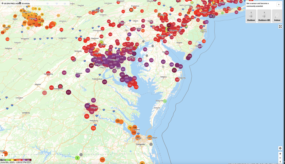
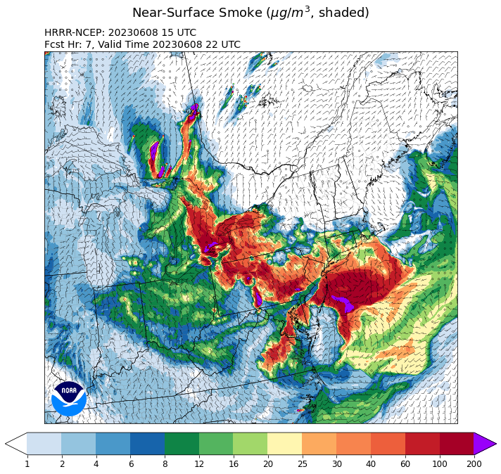
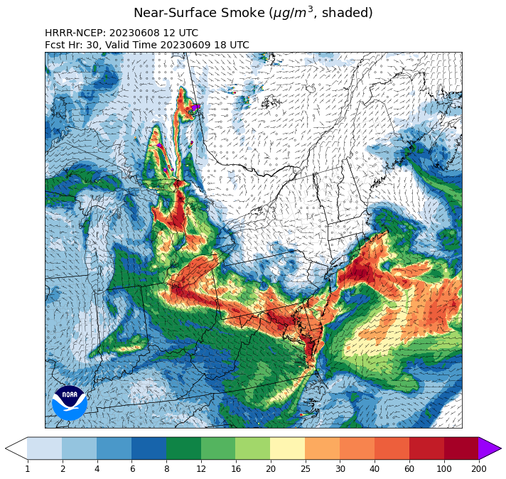
Consistent with reports in this thread, low-level smoke concentrations are dropping in areas north and northwest of DC. Still lousy air but some modest improvement: The HRRR smoke products have been consistently showing this scenario. Here is the latest run's forecast for low-level smoke later this afternoon. Tomorrow, unfortunately, looks worse again:
-
The HRRR smoke very clearly shows the low-level smoke concentrations dropping this afternoon, especially for areas northwest of DC.