high risk
-
Posts
3,241 -
Joined
-
Last visited
Content Type
Profiles
Blogs
Forums
American Weather
Media Demo
Store
Gallery
Everything posted by high risk
-
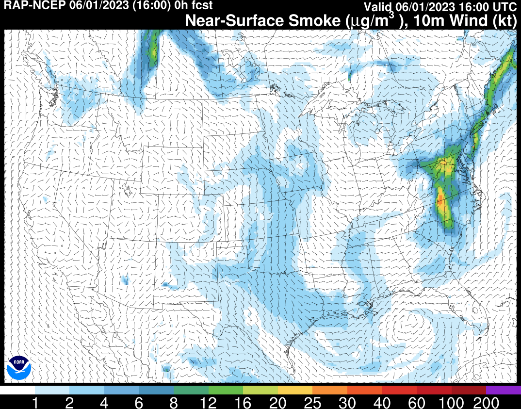
The HRRR smoke products have been excellent at showing the extreme low-level concentrations across our area this morning. The model is showing a significant improvement later today for northern areas, as the heavy low-level smoke is shunted south before another wave of higher concentrations arrives during the late evening. Forecast for 5PM:
-
Incredible amount of smoke in the sky this morning, and consistent with what a few others have noted, I'm also starting to smell some smoke. This is consistent with the HRRR smoke output which has shown that the smoke will work its way down to the surface today, starting very early this morning.
-
Agreed. It's bleak for the next week, but all of the ensembles show rainfall flipping to near or even above normal starting next week and potentially lasting at least a couple of weeks. And the deterministic solutions are starting to key in on a potential system early next week to get things started.
-

2023 Mid-Atlantic Severe Wx Thread (General Discussion)
high risk replied to Kmlwx's topic in Mid Atlantic
I *think* you're correct. The MRGL on the 16th got close to the southern counties of LWX's CWA, but it looks like it stayed just south.- 2,785 replies
-
- 2
-

-
- severe
- thunderstorms
- (and 3 more)
-
Ah, you nailed it.
-
Yeah, second week of June looks better, but that is still only "normal" rainfall according to the GEFS, GEPS, and Euro ensembles. The CFS is the only system hinting at above-average rain. And Saturday's opportunity looks to be fleeting for those of us on the east side of the Potomac. The front looks to crash through early and shift the best shower/storm potential to areas west and southwest of DC.
-
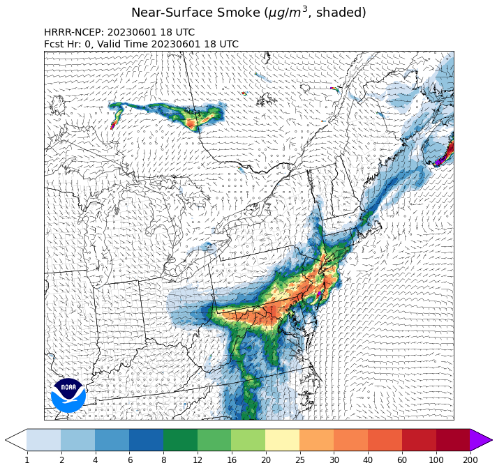
Source is fires over Nova Scotia

-
This post did not age well.
-
NAM and GFS starting to come into agreement for an ugly Sunday, with lots of clouds and periods of light rain and drizzle keeping temps in the lower 60s.
-
2023 Mid-Atlantic Severe Wx Thread (General Discussion)
high risk replied to Kmlwx's topic in Mid Atlantic
All good points. As you said, our best potential for a good combination of shear and instability is that mid-May to mid-late-June period. Events prior to that usually lack instability, and events later in summer often lack good shear. That said, we still usually get a few severe watch boxes in July and maybe August, and a tornado season can occur in the fall if the tropics are active.- 2,785 replies
-
- 2
-

-
- severe
- thunderstorms
- (and 3 more)
-
2023 Mid-Atlantic Severe Wx Thread (General Discussion)
high risk replied to Kmlwx's topic in Mid Atlantic
It still kind of looks that way, but wow - it's beyond discouraging for at least the next week and likely beyond for any kind of decent convection. For me, the climatological peak of SVR in the Mid-Atlantic is roughly May 10 to June 20, and we sure are wasting it right now.- 2,785 replies
-
- 2
-
-

-
- severe
- thunderstorms
- (and 3 more)
-
Yikes - the 00Z model suite has really dried out Saturday.
-
Simulated radars today show some very impressive reflectivity values. With the low freezing levels, I would think some small hail is possible if the updrafts are as strong as progged.
-
I wonder if that's connected to May being a peak season for backdoor cold fronts. The signal here in the Mid-Atlantic certainly looks "wedgey".
-
2023 Mid-Atlantic Severe Wx Thread (General Discussion)
high risk replied to Kmlwx's topic in Mid Atlantic
Damage pictures from the Va Beach area are pretty impressive. We had discussed further up in this thread a concern for a tornado threat with a strong low pressure center passing just to our northwest. The actual track of the low ended up well south of here, so we were out of the threat, but the low tracked just northwest of the Tidewater area, so this event is not a major surprise.- 2,785 replies
-
- 4
-
-
- severe
- thunderstorms
- (and 3 more)
-
Which precip field? I see the big totals up in central PA in the probability-matched mean, but I'm seeing only 1-1.5" for most of the Delmarva.
-
2023 Mid-Atlantic Severe Wx Thread (General Discussion)
high risk replied to Kmlwx's topic in Mid Atlantic
The other question now is whether the surface low will actually track to our northwest and put the DC area into the warm sector Sunday afternoon. The evening CAM guidance tracks the low across far southern MD or the northern neck of VA and keeps the severe threat a decent distance to our south. -
2023 Mid-Atlantic Severe Wx Thread (General Discussion)
high risk replied to Kmlwx's topic in Mid Atlantic
Need to watch Sunday. It's unclear how much morning/midday rain will limit surface heating and destroy mid-level lapse rates, but anytime a deep low pressure center passes by to our northwest, it bears watching. 12Z NAM Nest and HiResW FV3 both suggest some late day strong convection in an environment with some respectable shear.- 2,785 replies
-
- 6
-
-
-
- severe
- thunderstorms
- (and 3 more)
-
round 2 now forming to the west, and HRRR thinks it will intensify and increase in coverage on the east side of the Potomac in a few hours. Won't be as widespread as round 1 but should add to precip totals for at least some of us
-
2023 Mid-Atlantic Severe Wx Thread (General Discussion)
high risk replied to Kmlwx's topic in Mid Atlantic
Box coming shortly. Instability won't be great this afternoon, but with the strong wind fields and ascent, I'm buying the idea of at least some damaging wind events.- 2,785 replies
-
- 3
-
-
- severe
- thunderstorms
- (and 3 more)
-
This morning U.S. CAMs have the lead line being the "show", with it arriving in the 2-4 pm range, followed by a few hours of more stratiform precip.
-
It's not just the NAM. It's pretty clear consensus across the modeling suite that we're looking at a strong convective line later in the day Saturday. Fortunately, it's timed well and has good moisture, so there is also consensus that it will drop some decent amounts and last for a few hours. There will be more runoff than we'd prefer, but we'll take what we can get.
-
2023 Mid-Atlantic Severe Wx Thread (General Discussion)
high risk replied to Kmlwx's topic in Mid Atlantic
The 500 mb forecasts look terrific for late Sunday, but I agree with SPC that the moisture ahead of the system right now looks iffy. The weakening Saturday wave don't help things at all, as it disrupts what might be a longer period of southerly flow into our currently very dry air mass.- 2,785 replies
-
- 2
-
-
-
- severe
- thunderstorms
- (and 3 more)
-
2023 Mid-Atlantic Severe Wx Thread (General Discussion)
high risk replied to Kmlwx's topic in Mid Atlantic
confirmed TOR on that Delaware cell- 2,785 replies
-
- 3
-
-
- severe
- thunderstorms
- (and 3 more)
-
(Should this discussion be in the SVR subforum?) What changed in the 18Z NAM Nest is that it now backs the sfc winds in the afternoon which allows low-level dew points to ramp up before the front arrives. This creates a thermodynamic and kinematic profiles that support supercells. it's quite a change from the earlier runs which had sfc winds veering by midday and low level dew points lowering significantly in the afternoon. I need to see this idea show up in the 00Z cycle and see it in other models before buying in.