Silas Lang
-
Posts
761 -
Joined
-
Last visited
Content Type
Profiles
Blogs
Forums
American Weather
Media Demo
Store
Gallery
Everything posted by Silas Lang
-
Yeah, I still look at all 3 and figure a split the difference approach is best. But really hard to even split the difference with the way the GFS has been. I swear, I thought the GFS did great last winter? Like, it seemed like it was out performing the Euro. But now, not so much. Yeah, I remember when Euro (the king) was pretty much a lock. I miss those days. It would be nice if we still had access to those older versions of the models.
-
Yeah even the Canadian seems more consistent. Don't know why the GFS has been so nuts lately. It's like a box of chocolates, you never know what you're going to get.
-
Yeah, should we lean more towards the Euro? I don't really know how the models have faired this winter or even how accurate they are with these over running setups. But the GFS has has been a completely different solution each run often this winter.
-
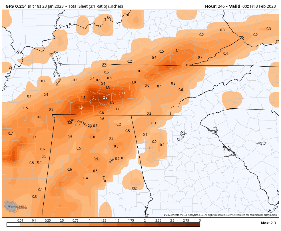
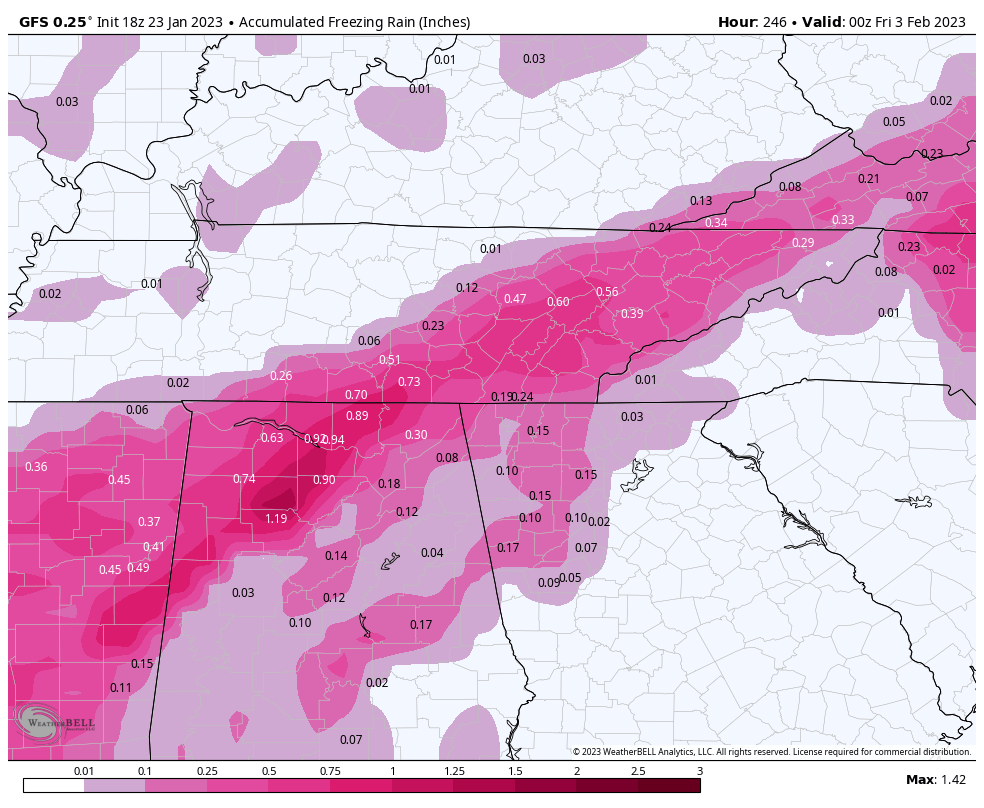
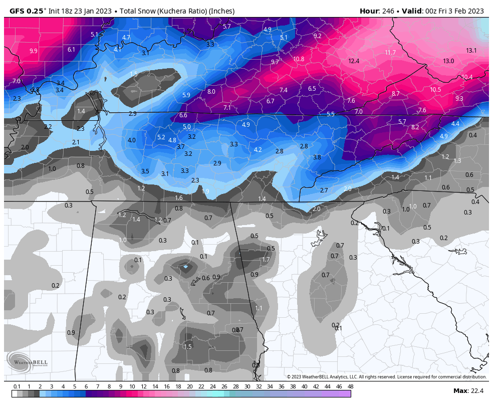
Finally got to see the Euro. System next week looks a little flatter. However, snow over the entire state. Roughly only an inch average with the winner being middle TN and northern plateau with 2 to 3. Much less ice. Last night's run only had snow in the northwest part of the state.
-
Looking at the Euro, it looks like the cold air is pushing a little more south an east, by about 50 to 100 miles compared to the 00z last night. This is regarding the potential overrunning next week.
-
Good lord. What event was that? You hope people understand enough to factor in some climo when looking at snow maps. I don't even know if SC has ever had that much snow in their history. If that was showing on models for the valley, I would give it some serious side eye. 6 to 8 inches is usually the upper end on big events around here, with something like a foot or more being a once in a lifetime storm (like 93). Anyways, I am a sicko and want to reel this one in. Even after having burst pipes from the last cold spell. I can't help myself. Some men just want to watch the world bu...er umm freeze. Let's see what the Euro brings!
-
Agree 100%. I am feeling pretty confident that some overrunning will occur. But it could still go anywhere at this point. Really depends on the cold push. I don't think it will miss us south. More likely north. The cold could get hung up on the plateau like the last time we had one of these events. Middle and West TN scored big while it rained here in the East for days. When was that? 2021?
-
Looks like it is delayed. Still just shows the 6z.
-
Yeah, the Euro last night looked similar to the Canadian and GFS. Pretty good to have all in agreement on that type of setup with as chaotic as the models have been this season. The pattern looks good, just hope we can score something!
-
Latest GFS looks different, but still winds up with a couple of inches of snow in the east. The Canadian also trying to show something at the end of it's run. Way too far out for specifics, but it is seemingly increasingly likely that there is a storm threat for someone in the southeast next week.
-
Yeah, 2015 was the last real big one I remember. I was in school at the time (student teaching) and I remember I was out for like 3 weeks. lol I forget if it was that year or another previous year, but I remember having some sort of snow/ice mix on the ground for a good chunk of the month of February. It would start to melt, but before it could clear out another storm would come and there were layers of frozen on the ground. Roads were awful for a while. This setup on the GFS with the the ice, sleet, snow, and cold reminded me of some of the those past setups. Hopefully we can score (but maybe without all the ice). February has always been the best month of winter in my mind.
-
This look reminds me a lot of Feb of years past. Storms with every p-type imaginable only to be followed by another. Can't remember the exact years, but somewhere between 2012 to 2015? Anyone remember? I just know there were a couple of Febs where we had some systems showing pretty much what the GFS just showed.
-
Yeah, it shows the potential. Even though the some of the other runs haven't shown a storm, the potential is definitely there for something like the GFS is showing. The first of Feb looks like a good window of opportunity.
-
January 2023 Medium/Long Range Pattern Discussion Thread
Silas Lang replied to Carvers Gap's topic in Tennessee Valley
Looks like some big overrunning potential still showing up on the GFS.- 923 replies
-
- 2
-

-
- warm start
- cold
- (and 4 more)
-
January 2023 Medium/Long Range Pattern Discussion Thread
Silas Lang replied to Carvers Gap's topic in Tennessee Valley
Ah, forget about snow days, schools will be getting some flood days instead. Reminds me of February a few years ago, forget which one, but it was rain, rain, rain.- 923 replies
-
- 1
-
-
- warm start
- cold
- (and 4 more)
-
January 2023 Medium/Long Range Pattern Discussion Thread
Silas Lang replied to Carvers Gap's topic in Tennessee Valley
The 6z GFS has the storm from the 18z (Jan 29), just a bit further east. It was gone on the 0z run. Another period to watch.- 923 replies
-
- 2
-
-
- warm start
- cold
- (and 4 more)
-
January 2023 Medium/Long Range Pattern Discussion Thread
Silas Lang replied to Carvers Gap's topic in Tennessee Valley
Real nice look. Great storm track with the classic low on the gulf coast to atlantic coast track.- 923 replies
-
- 2
-
-
- warm start
- cold
- (and 4 more)
-
January 2023 Medium/Long Range Pattern Discussion Thread
Silas Lang replied to Carvers Gap's topic in Tennessee Valley
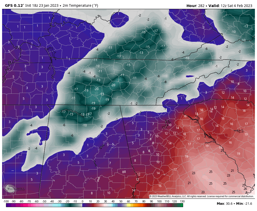
Hopefully the cold pattern materializes and actually happens. I swear, outside of 5 days, the models show a different solution everytime. Maybe that's a sign they are struggling with an upcoming pattern change?- 923 replies
-
- 1
-
-
- warm start
- cold
- (and 4 more)
-
Had a nice snow burst earlier when I was outside in the jacuzzi, living the dream with a nice beverage in hand. Still snowing lightly, but looks to be winding down. Not much, but will probably end this with a solid dusting. Hey, that's pretty great for the central valley in a NWF event. I can't complain as that's an over performer considering the situation. Any reports from Johnson City? That was the best location I have lived in for these types of events. Seems like we could squeeze out an inch, which is feasting for NWF in the valley.
-
It looks like the RGEM is picking up the "streamers" a bit better than the NAM, which shows no real evidence of them on the snow maps. Now, even if the RGEM is correct on some streamers bursting through the valley, where they set up is anyone's guess. Places could get blanked, while others could get a dusting to an inch. These things are very hard to predict. NAM seems convinced this is a typical elevation event.
-
Wow, a tornado warning has been issued for Jefferson County. Stay safe, folks. Pretty intense storms so far.
-
January 2023 Medium/Long Range Pattern Discussion Thread
Silas Lang replied to Carvers Gap's topic in Tennessee Valley
I don't know how much this plays a part, but it seems pretty common to get a storm on MLK day weekend. We had snow on the ground last year at this time.- 923 replies
-
- 2
-
-
- warm start
- cold
- (and 4 more)