Silas Lang
-
Posts
761 -
Joined
-
Last visited
Content Type
Profiles
Blogs
Forums
American Weather
Media Demo
Store
Gallery
Everything posted by Silas Lang
-
Canadian is a beautiful rainstorm with a weird southern plateau jackpot of snow.
-
Will say, at a quick glance it did seem warmer though. Very close temps. Like any closer and this will be a monsoon. lol
-
A tick back to the west on the GFS. TRI and the mountains would love that outcome. Pretty steep cutoff. Wouldn't take a lot to get more people involved.
-
Well 18z Euro was more West and the 0z NAM is more East. Where will the GFS go? This is going to be rough couple of days. Would rather be too far NW at the moment if I had to choose.
-
Got love the timing of this thing for us at this juncture. Marginal temps, but middle of the night with potentially heavy rates could make all the difference. You get something on the ground before daybreak and it could help tremendously with accumulation.
-
Do we want the storm to become stronger to pull more west? What is the mechanism that keeps it towards TN and not too far east?
-
Yeah, if I get an inch I will be happy. Any more is gravy. It is also fun to watch as these systems can puke snow.
-
I'm afraid to even talk about it. lol If we get a few more runs like this, I do want someone to make a thread. I like having them for historical purposes, boom or bust.
-
Jan 31 - Feb 1 Ice Possibilities
Silas Lang replied to Holston_River_Rambler's topic in Tennessee Valley
Anyone have any current observations? -
Yeah, I am curious too. I looked at the upper air temp maps, and they look pretty good for everyone, but there must be a warm layer for the valley. Don't have access at the moment, but could you put up a sounding for Knoxville?
-
Jan 31 - Feb 1 Ice Possibilities
Silas Lang replied to Holston_River_Rambler's topic in Tennessee Valley
Man, why ain't more people posting? Was hoping to see some reports! Pics? Observations? -
Jan 31 - Feb 1 Ice Possibilities
Silas Lang replied to Holston_River_Rambler's topic in Tennessee Valley
Not really. Even if temps do get below freezing, it would barely get there, and for a short period of time at that. With warm ground temps, I don't think it would really be eventful regardless. This is a West and Middle TN event. -
Jan 31 - Feb 1 Ice Possibilities
Silas Lang replied to Holston_River_Rambler's topic in Tennessee Valley
Well, a guess a large group of posters in the east aren't too thrilled with a week of cold rain. To be fair, it is a gross, nasty, 40 degree rain. Just a bleak affair here, the grass is practically mud. There are still a few here posting though! -
Jan 31 - Feb 1 Ice Possibilities
Silas Lang replied to Holston_River_Rambler's topic in Tennessee Valley
Yeah, that's what I thought. The cold is definitely pressing. Tuesday into Wednesday it even suggests temps of around 34 in the central valley. The NAM looks to be similar. Still, doubt it based on prior events. It's close though. -
Jan 31 - Feb 1 Ice Possibilities
Silas Lang replied to Holston_River_Rambler's topic in Tennessee Valley
Probably the plateau? -
Even in TRI there is some variety in climate. It always seemed Kingsport and Bristol did better with the big storms, and JC was better with NWF and snow shower like setups. I have wonderful memories of randomly getting hammered with a snow shower and picking up an inch of snow while in JC. Best location I have lived in for those types of events.
-
Jan 31 - Feb 1 Ice Possibilities
Silas Lang replied to Holston_River_Rambler's topic in Tennessee Valley
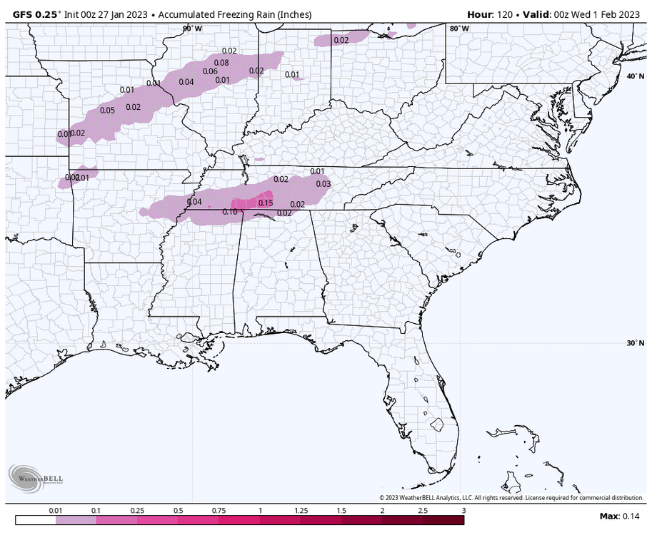
Yeah, I noticed that. Pretty substantial difference in places that were already below freezing as well. 3 to 4 degrees colder. Unfortunately, it makes the risk for ice much worse in places like west and middle TN. If it stays at 31-32, it probably won't be too bad. But if creeps into the upper 20s... -
Yeah, for this reason I am about to punt next Tuesday's event for the East. West has the best chance of scoring!
-
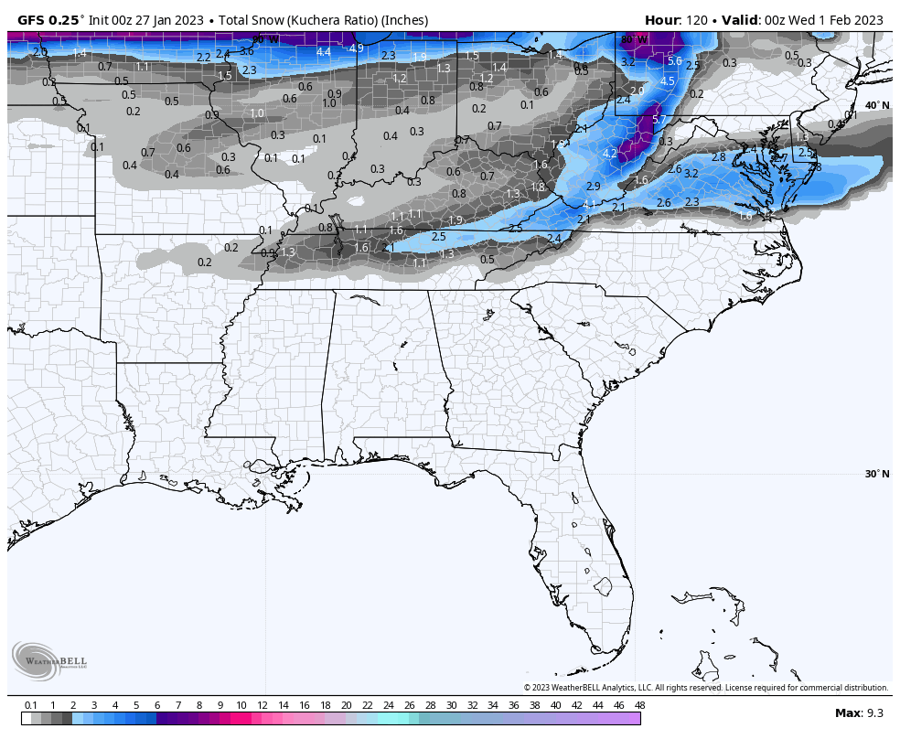
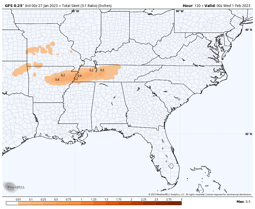
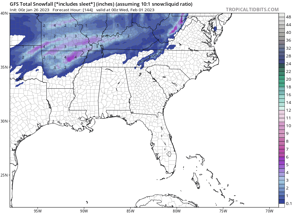
Here is the p type break down. Note that this doesn't include a potential second wave.


-
Using the totally valid metric of clown maps, it's pretty easy to see the potential for next week. Nothing crazy, but a statewide 1 to 3 inches doesn't sound unreasonable. I haven't dug in, so I don't how much of this is ice or sleet, but still a winter event regardless. Just need to get a little more southern jog to get the whole state. The trend is good on the GFS!

-
Although looking at the Canadian, it follows more of the pattern we have had this winter of LPs going almost due north to Ohio. Hopefully it's just sniffing glue, but I'm not really sure what's preventing that scenario from happening.
-
I am starting to feel pretty confident for winter weather in the western part of the state. Less confidence as you go east and south. The trend today is further south. It is also nice to finally see something similar on the GFS and Euro. Let's see if it holds or continues.
-
Suppression is the trend. Just need a little bit more! For those in the east, do we want the cold air to be coming from a more North to South angle like the 12z? Seems coming from the west it would be more likely to get hung up on the plateau.
-
I hear you. The chase is part of the fun! I think it also helps to have realistic expectations. We average about 6 inches of snow a year here. Sometimes that means we get it all in one dump (Christmas a couple of years ago), get a few small events, or even nothing one year and 12 inches the next. At least I live in a place where I get to see some snow falling every year, even it it's just flurries or a snow shower. Some places don't even get that. I think people that are the most miserable with this hobby are those who expect a massive snowstorm every year, are never satisfied with snow amounts, etc. I just want to be like "you live in the south east, stop complaining, and enjoy what you have!" And on the topic of unexpected, what about that Vols football team this year? Simply magical. Never been more invested than when I was a teen in the golden era. But, yeah this place is great! I really enjoy your posts and all the others that can explain things that I can't. This forum is my free entertainment during the winter.