Silas Lang
-
Posts
761 -
Joined
-
Last visited
Content Type
Profiles
Blogs
Forums
American Weather
Media Demo
Store
Gallery
Everything posted by Silas Lang
-
January 15th-17th 2024 Arctic Blast/Snow Event
Silas Lang replied to John1122's topic in Tennessee Valley
Yeah I think a lot of bias is playing into the ratio forecasting much like mixing is. I think the depth and strength of the cold isn't really being modeled well by most and that ratios will be higher likely than most models are showing. So...if this bias is showing in the short range models, does that mean some locations could possibly see something like 50% more snow than modeled? Goodness. -
January 15th-17th 2024 Arctic Blast/Snow Event
Silas Lang replied to John1122's topic in Tennessee Valley
Here is the Canadian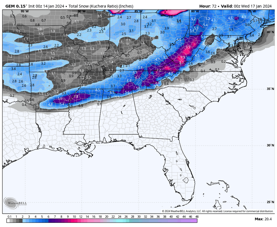
-
January 15th-17th 2024 Arctic Blast/Snow Event
Silas Lang replied to John1122's topic in Tennessee Valley
And here is the 0z GFS
-
January 15th-17th 2024 Arctic Blast/Snow Event
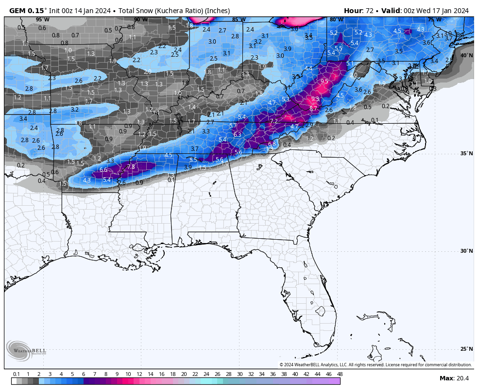
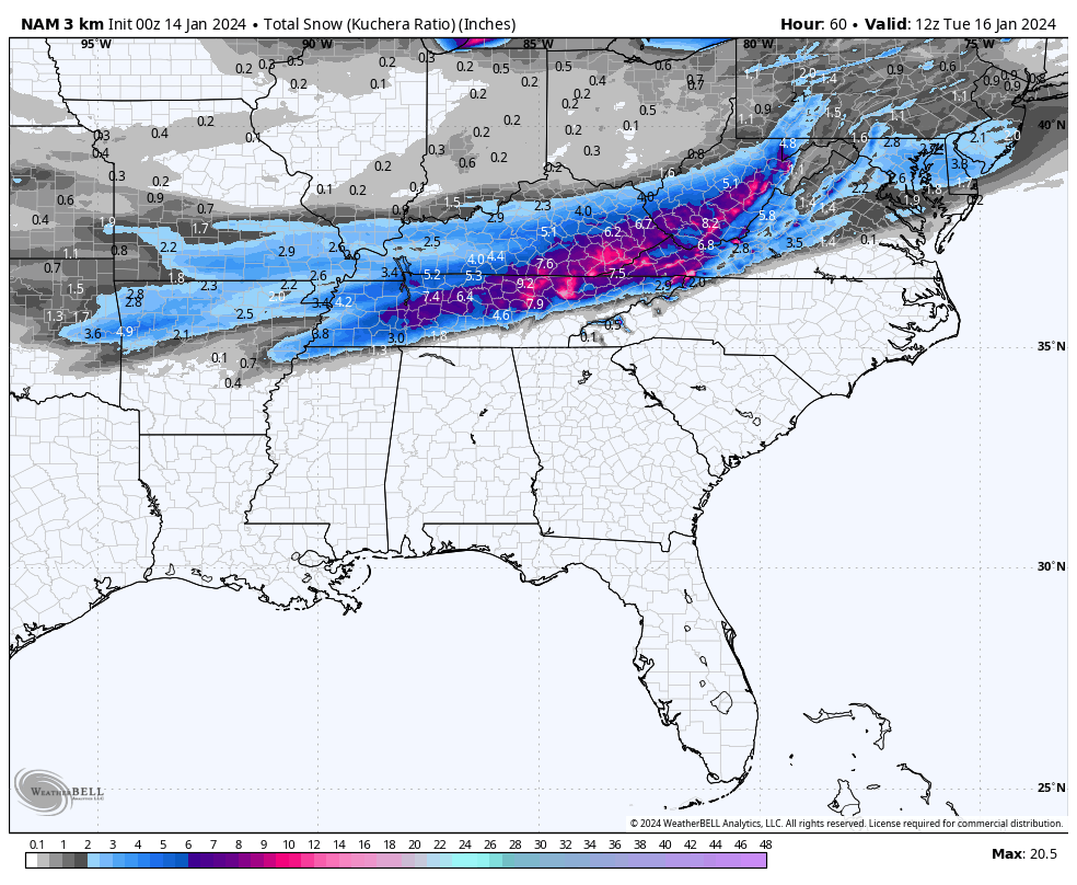
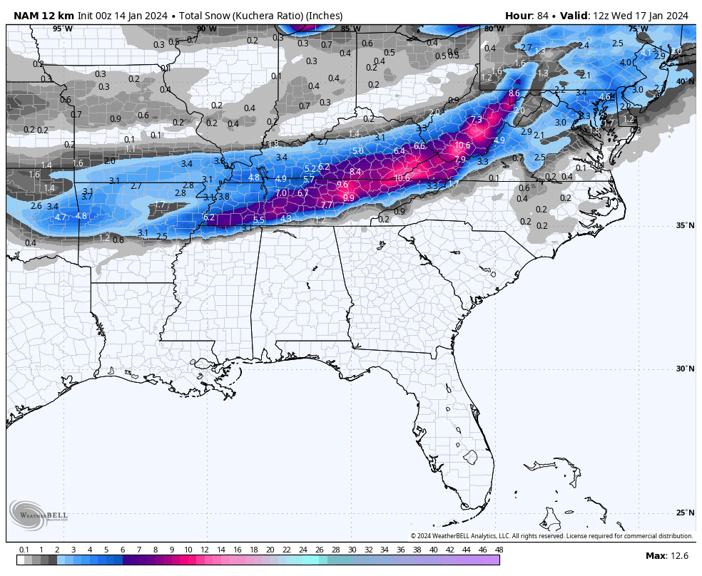
Silas Lang replied to John1122's topic in Tennessee Valley
Here is the NAM
-
January 15th-17th 2024 Arctic Blast/Snow Event
Silas Lang replied to John1122's topic in Tennessee Valley
Latest ICON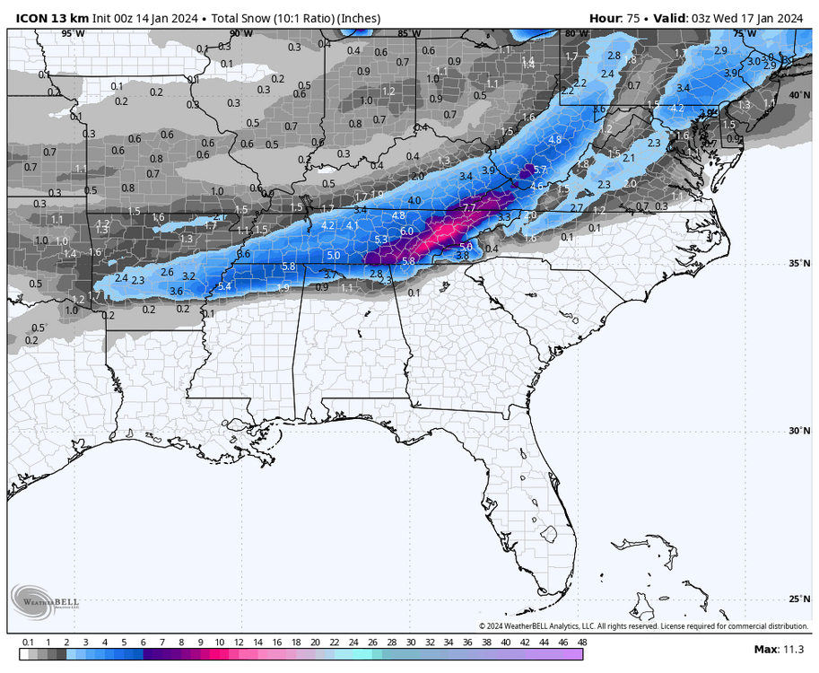
-
January 15th-17th 2024 Arctic Blast/Snow Event
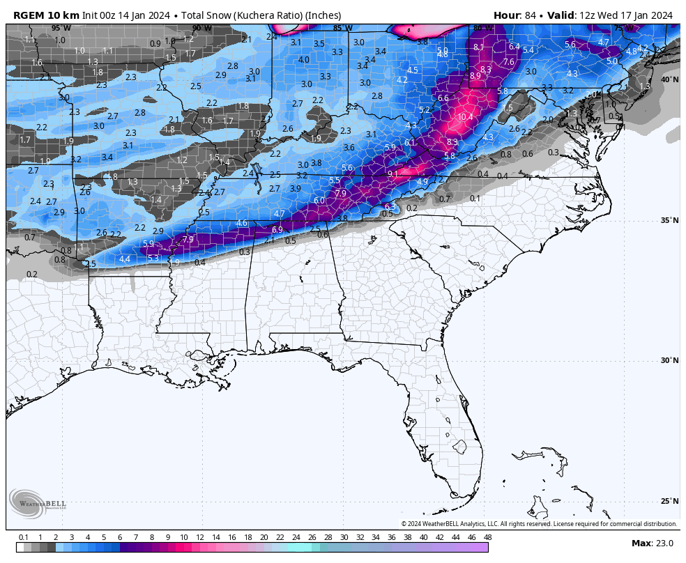
Silas Lang replied to John1122's topic in Tennessee Valley
0z RGEM pretty much the same as the 18z, but gives a little bit more to areas favored last run.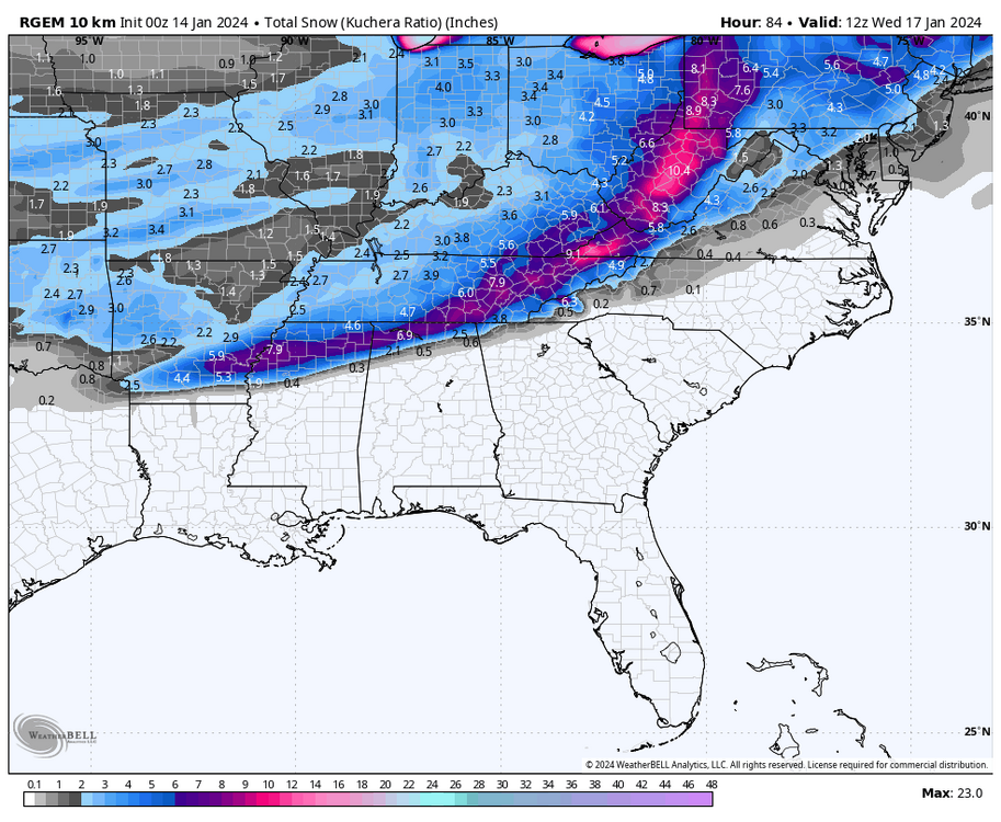
-
January 15th-17th 2024 Arctic Blast/Snow Event
Silas Lang replied to John1122's topic in Tennessee Valley
Looks like the NAM has trended south with it's precipitation. Looks much closer to other guidance now. Should be a huge sigh of relief to those of us in the East. lol -
January 15th-17th 2024 Arctic Blast/Snow Event
Silas Lang replied to John1122's topic in Tennessee Valley
Maybe a dumb question, but is low level moisture impacted by ground moisture? I just say this because I remember some time ago reading about it, but forget the exact science behind it. -
January 15th-17th 2024 Arctic Blast/Snow Event
Silas Lang replied to John1122's topic in Tennessee Valley
Not sure if this is the same or different mechanism, but this was the one storm I was thinking about. I remember my parents got blasted in Anderson County, backed up against the plateau and I got nada in JC. lol -
January 15th-17th 2024 Arctic Blast/Snow Event
Silas Lang replied to John1122's topic in Tennessee Valley
I have seen similar situations pan out when living in Johnson City. Sorry @tnweathernut -
January 15th-17th 2024 Arctic Blast/Snow Event
Silas Lang replied to John1122's topic in Tennessee Valley
Yeah, it wasn't that bad at all. That warm air is at the end is also at peak sunlight hours. I imagine as the sun sets the cold ploughs ahead just fine. Most of the east is below freezing regardless. I will take the precip the HRRR is selling and roll the dice with artic air nearby. -
January 15th-17th 2024 Arctic Blast/Snow Event
Silas Lang replied to John1122's topic in Tennessee Valley
Man, what model is wbir using? Just caught the "futurecast" from them and the moisture and cold looks beefy. No concerns if you are on the NW or SE fringe according to that model. Of course they didn't show any totals yet. Just found it odd as usually it always seems the news network models are the ones that show the least amount of snow. lol -
January 15th-17th 2024 Arctic Blast/Snow Event
Silas Lang replied to John1122's topic in Tennessee Valley
So it pretty much makes it a niña like storm? Trying to remember, but seems like there have been a few the past couple of years where the whole state gets snow while the east gets cold rain with the cold air just hanging out on the edge of the plateau. One storm in particular I remember models busted as we got mostly rain here and no snow. -
January 15th-17th 2024 Arctic Blast/Snow Event
Silas Lang replied to John1122's topic in Tennessee Valley
Canadian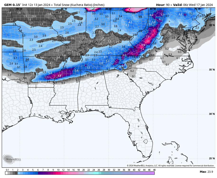
-
January 15th-17th 2024 Arctic Blast/Snow Event
Silas Lang replied to John1122's topic in Tennessee Valley
Yeah looking at the snow output it actually doesn't look too much different. CMC is still a little stronger with more precipitation. -
January 15th-17th 2024 Arctic Blast/Snow Event
Silas Lang replied to John1122's topic in Tennessee Valley
GFS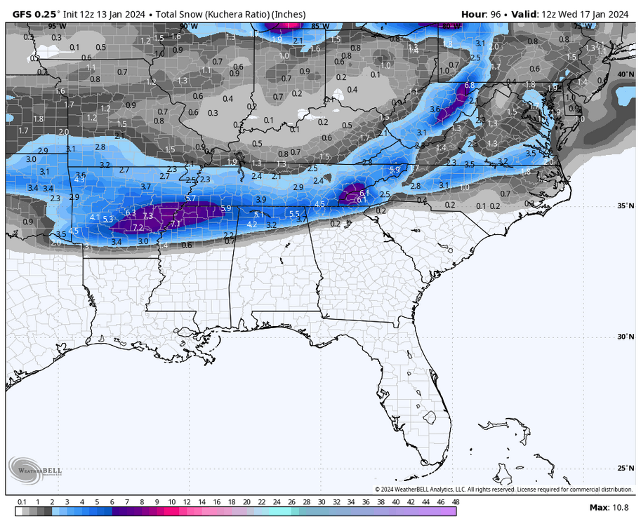
-
January 15th-17th 2024 Arctic Blast/Snow Event
Silas Lang replied to John1122's topic in Tennessee Valley
GFS Southeast and less precipitation. -
January 15th-17th 2024 Arctic Blast/Snow Event
Silas Lang replied to John1122's topic in Tennessee Valley
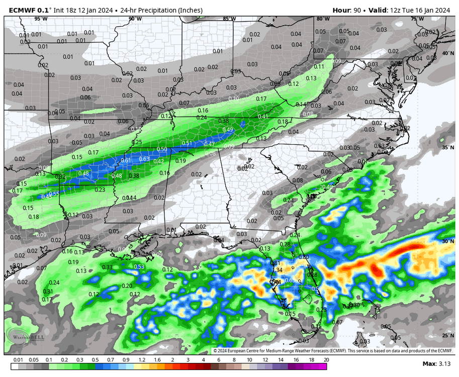
I do wonder about QPF too. Every system has been underdone here lately. An extra .20 inch of liquid could be a huge deal with this air mass and result in several more inches of snow. -
January 15th-17th 2024 Arctic Blast/Snow Event
Silas Lang replied to John1122's topic in Tennessee Valley
Snow map looks almost identical to GFS. -
January 15th-17th 2024 Arctic Blast/Snow Event
Silas Lang replied to John1122's topic in Tennessee Valley
Haha no worries! I just wanted to look for myself and noticed that the precipitation seems to be pretty much 10 to 1 or a little better. Wondering if with the cold air if we could squeeze some more out of it. -
January 15th-17th 2024 Arctic Blast/Snow Event
Silas Lang replied to John1122's topic in Tennessee Valley
Anyone else see it or am I wish casting here? lol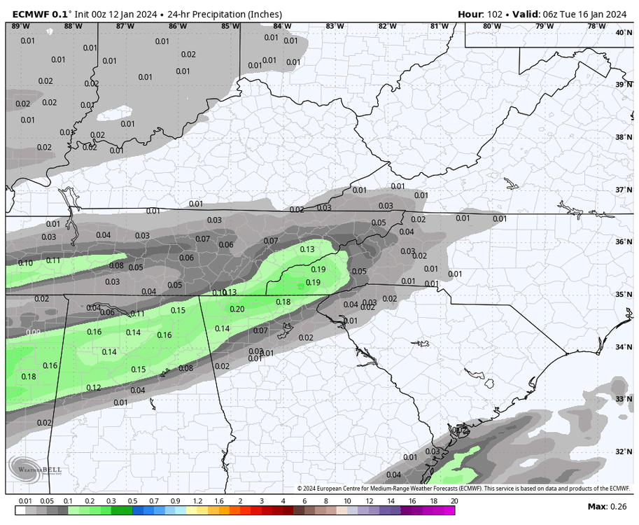

-
January 15th-17th 2024 Arctic Blast/Snow Event
Silas Lang replied to John1122's topic in Tennessee Valley
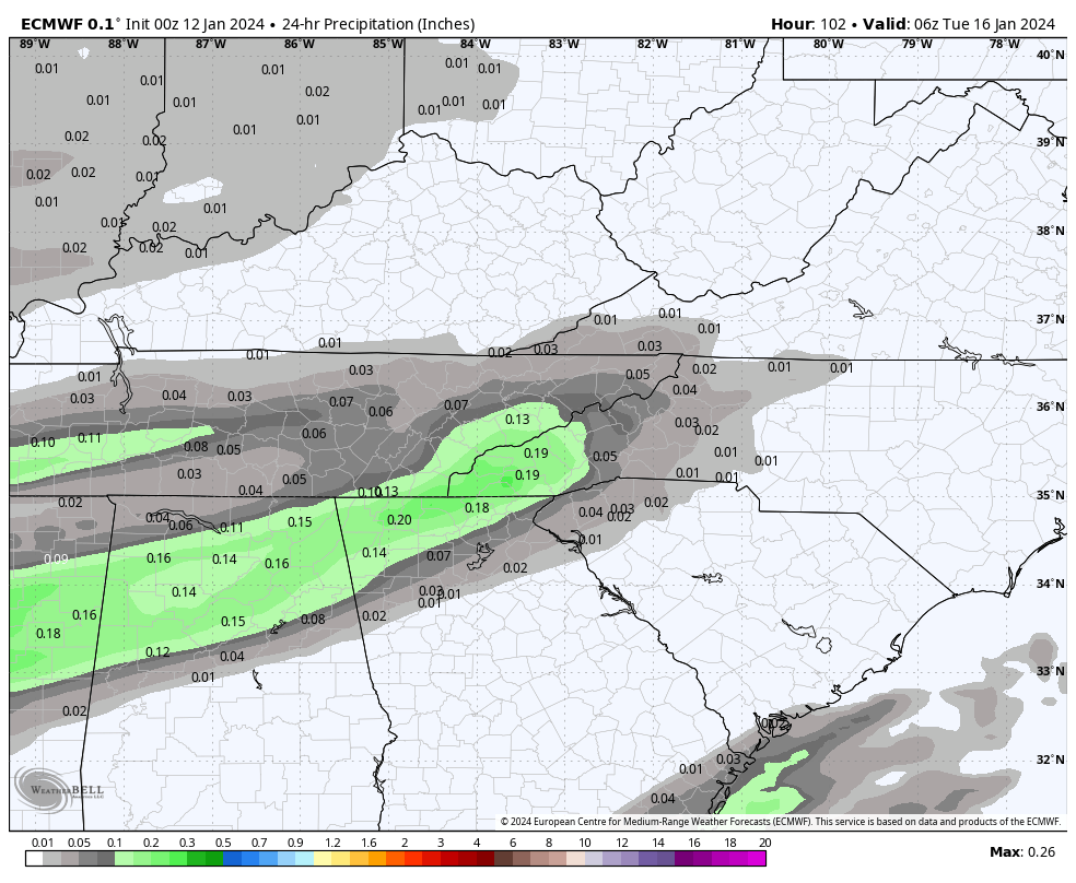
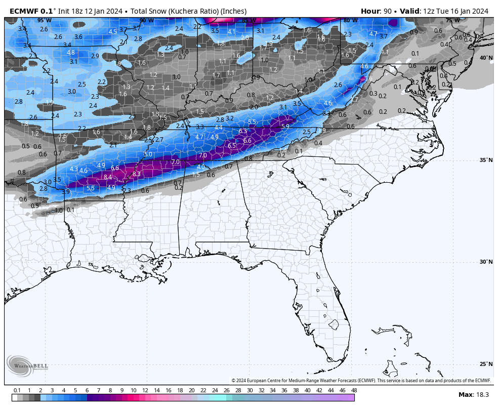
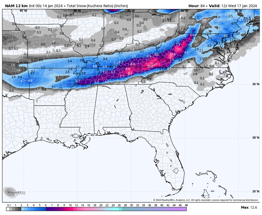
Actually QPF is up a bit. And looking at it versus snowfall, I actually have to wonder if the snow is under modeled. Looks like precipitation to snow on maps is roughly showing up as 10 to 1 ratio, even on the kuchera maps. -
January 15th-17th 2024 Arctic Blast/Snow Event
Silas Lang replied to John1122's topic in Tennessee Valley
Pretty big threat if they are posting graphics suggesting two inches in the valley this far out. -
January 15th-17th 2024 Arctic Blast/Snow Event
Silas Lang replied to John1122's topic in Tennessee Valley
Yeah, I just want to see something similar and it is starting to look like it is falling in line, despite the QPF. It looks way better than the 12z yesterday. -
January 15th-17th 2024 Arctic Blast/Snow Event
Silas Lang replied to John1122's topic in Tennessee Valley
So it looks like the Euro caved for the first part of the storm, but doesn't really get a coastal going like the other models. To me it looks like Euro is catching up to everyone else.