Silas Lang
-
Posts
761 -
Joined
-
Last visited
Content Type
Profiles
Blogs
Forums
American Weather
Media Demo
Store
Gallery
Everything posted by Silas Lang
-
February 2024 mid/ long range
Silas Lang replied to Holston_River_Rambler's topic in Tennessee Valley
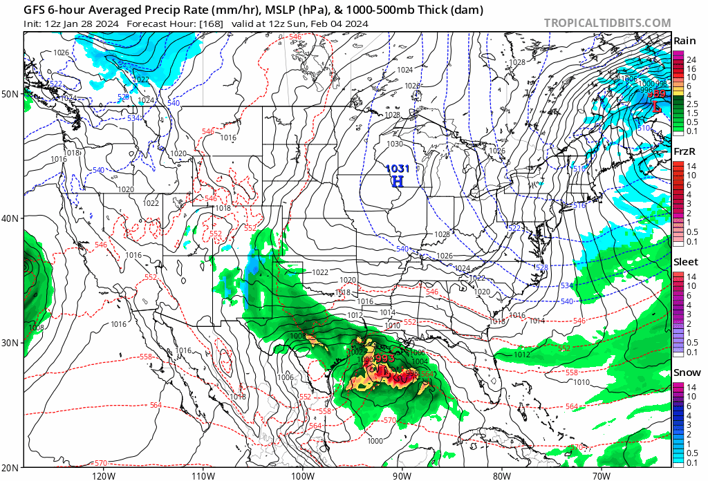
12z GFS interesting. Flirting with something big on the 5th.
- 750 replies
-
- 4
-

-

-
- snow elk
- wooly worm
- (and 1 more)
-
The Cumberland mountains look like they are getting hammered. Hard to see through the clouds, but looks like areas over 2500 feet or so are white.
-
February 2024 mid/ long range
Silas Lang replied to Holston_River_Rambler's topic in Tennessee Valley
Man, that is weird about the grass. Was noticing today that mine looks way greener than before the snow. Does all that moisture from the snow and protection from bitter cold with snowpack, help the grass or something? And about the models struggling with all the niña data, the snowstorm we just experienced was modeled as a cutter, similar to the past couple of years until they finally settled on what we got, more or less.- 750 replies
-
- 2
-
-
- snow elk
- wooly worm
- (and 1 more)
-
February 2024 mid/ long range
Silas Lang replied to Holston_River_Rambler's topic in Tennessee Valley
Yeah, the GFS has the same storm, but sends it out to sea. The Euro is a little confusing with low pressure popping up everywhere. Some potential in the time period for sure!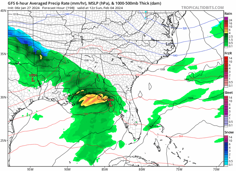
- 750 replies
-
- 3
-
-
- snow elk
- wooly worm
- (and 1 more)
-
Same here. Pretty crazy. Got a fresh coat. I can't see the yellow spots from the dog! lol
- 372 replies
-
- 7
-
-
- cold
- arctic blast
- (and 1 more)
-
Man it is really coming down now. A stout NWF for the valley.
- 372 replies
-
- 4
-
-
- cold
- arctic blast
- (and 1 more)
-
Some flurries/ light snow. Already got a dusting on top of the ice. 32 now. Looking at thermometer it hovered between 30 to 33 last night. It's a mess.
- 372 replies
-
- 2
-
-
- cold
- arctic blast
- (and 1 more)
-
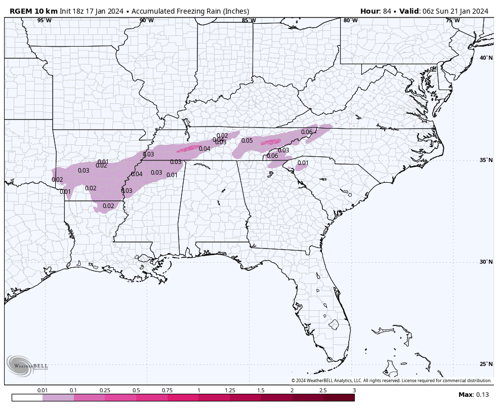
Disappointed to say that I have had a couple of brief showers of freezing rain. It wasn't a downpour, but the drops were heavy and it was a moderate rainfall. I expected drizzle or maybe light rain briefly, but this is more than I anticipated. I have had drizzle in between the moderate showers. I heard what sounded like a brief period of sleet. It's nasty out. I have no idea how to measure ice, but it is a much thicker than a light glaze. Dog slipped going out. It has consistently been 31, but I am sure the ground is much colder. A cool little element from this weather is due to some melting from sun in cold temps and the freezing rain, I have some rather sick looking icicles hanging off the house. I swear one of them is closing in on 3 feet. Gonna have to measure tomorrow. Anyway, stay safe y'all.
- 372 replies
-
- 2
-
-

-
- cold
- arctic blast
- (and 1 more)
-
Is Knox getting dry slotted? I am 100% okay with this. Have a had a little drizzle and melt from sun today so I already have enough ice!
- 372 replies
-
- 1
-
-
- cold
- arctic blast
- (and 1 more)
-
It really is worse for it to be light. When I lived in Asheville, new years eve 2017, it sprinkled for maybe 5 or 10 minutes? But the temps has been cold and it instantly made the roads treacherous. I had to walk home five miles because I almost died driving and just decided to park the truck, wasn't worth it. Numerous wrecks, stalled traffic, terrible all around and all over like .01 inch of freezing rain. Worst part was you couldn't even see any ice. But my truck certainly felt it. Needless to say, one of the few new years I spent alone. lol
- 372 replies
-
- 4
-
-
- cold
- arctic blast
- (and 1 more)
-
A bit off topic, but it drives me nuts how TYS is "Knoxville." It was the same when I lived in Johnson City and "TRI" was the official record. Honestly that one is worse because Bristol, Kingsport, and JC all can have vastly different conditions. It was even similar when I lived in Asheville and "AVL" was very similar to "TYS" where the airport is well south of the city proper and would get blanked at times the city would get a couple of inches. I mean, how hard is it to have an official record for towns and cities? Drives me nuts. Should be easier than ever with tech too.
-
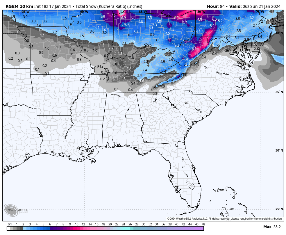
My fears look like they are coming to fruition. Ice, ice baby. Oddly enough, the RGEM is actually trending the snow line into the central valley with limited ice the past couple of runs. Curious to see if the 12z holds. I want that solution to be correct! lol
- 372 replies
-
- 3
-
-
-
- cold
- arctic blast
- (and 1 more)
-
My thing is, I think we can easily stay below freezing at the surface, but we still get rain. It will just be freezing rain. A little warm air up high is not impacted by the ground. Maybe best case, there is lower level cold that keeps it sleet or something? I don't know. Just worried about the impacts of this rain on 9 inches of snow. I would love snow instead!
- 372 replies
-
- 5
-
-
-
- cold
- arctic blast
- (and 1 more)
-
RGEM is persistent. Also been the best with temps, for me at least. It shows a chilly upper 20s in the early morning hours with rain for the central valley. Temp profiles seem to highlight snowpack fairly well.

- 372 replies
-
- 3
-
-
- cold
- arctic blast
- (and 1 more)
-
I think that even if we make it to the mid 30s the ground is so cold and frozen, it could still freeze up in spots. My road is nasty. Compacted snow several inches thick. I think they tried to plow it, but it just made it solid? Anyway, rain will not help that glacier.
- 372 replies
-
- 3
-
-
- cold
- arctic blast
- (and 1 more)
-
Honestly even Monday could be another day or at least a delay. That's the first real "warm" day, but it is still supposed to be very cold in the morning. Anyway, secondary roads are awful all over Knox. I live in the city proper and still no plow. Not that it would do much with all the compacted snow and ice.
-
Yeah, I noticed the GFS went a little north. Almost like RGEM and GFS have met in the middle. If I had to guess, I assume places with a thick snowpack will hover just at or below freezing, resulting in freezing rain or snow. The valleys may fair better since they will pool cold air. Wondering if MRX will pull the trigger on an advisory. I think it's needed if for precaution if nothing else. People may falsely believe that their roads are clear and not realize that it's just a sheet of ice. Temps should fall on Friday too.
- 372 replies
-
- 3
-
-
- cold
- arctic blast
- (and 1 more)
-
Also, would this event register for an advisory? Friday will have dropping temps even if they manage to get above freezing in the morning. I can imagine it will be a huge mess, even if precip is limited and rain...
- 372 replies
-
- 1
-
-
- cold
- arctic blast
- (and 1 more)
-
Speaking of models and temps, I noticed the NAM was about 10 degrees warmer than RGEM for this morning. I think the RGEM is doing better with temps and picking up snowpack. For this reason, I think I trust it more than the NAM for this event. Now, looks like for some areas that will be freezing rain, but still frozen. NAM wants cold rain for all.
- 372 replies
-
- 1
-
-
- cold
- arctic blast
- (and 1 more)
-
January 15th-17th 2024 Arctic Blast/Snow Event
Silas Lang replied to John1122's topic in Tennessee Valley
-5 is what my thermometer shows. -
0z GFS essentially the same as 18z. A hair north and less precip, but still shows snow.
- 372 replies
-
- 2
-
-
- cold
- arctic blast
- (and 1 more)
-
Looks like the RGEM has been trending south with that snow line.
- 372 replies
-
- 2
-
-
- cold
- arctic blast
- (and 1 more)
-
Man, a solid hit. Regardless of totals, even a half inch would feel big on top of this snow pack. So it's GFS vs the world? lol
- 372 replies
-
- 5
-
-
- cold
- arctic blast
- (and 1 more)
-
January 15th-17th 2024 Arctic Blast/Snow Event
Silas Lang replied to John1122's topic in Tennessee Valley
Yeah I measured 8 to 9 in places in the yard, though hard to tell since some sleet and rain had compacted it. Also found some deep pockets of 10 to 11. Drifts? Anyway, Pretty cool storm. Ended up with a final half inch last night to recoat what I had cleaned up too.