Silas Lang
-
Posts
761 -
Joined
-
Last visited
Content Type
Profiles
Blogs
Forums
American Weather
Media Demo
Store
Gallery
Everything posted by Silas Lang
-
Surface is 32 to 33 here in north knox. Had some sleet mixed in with drizzle. Was mostly drizzle last I checked. Could get ugly if temps keep dropping and we don't get the switch to snow. I don't think anyone is paying attention to this and roads could get bad quick.
-
Jan 30th-February 1st 2026 Arctic Blast/ULL Snow OBS Thread.
Silas Lang replied to John1122's topic in Tennessee Valley
I took a peak at the HRRR, NAM, and RGEM last night before bed. NAM had Knoxville at a low of 14 or 15, HRRR at 11, and RGEM around zero. Thought it would be interesting to see how the short range are handling the cold air. My thermometer got down to 6 here. So not quite as cold as the RGEM showed, but it seems to be doing good with correctly modeling the depth of cold. -
Jan 30th-February 1st 2026 Arctic Blast/ULL Snow OBS Thread.
Silas Lang replied to John1122's topic in Tennessee Valley
What is your total right now? I just measured about an inch here near Fountain City. -
Jan 30th-February 1st 2026 Arctic Blast/ULL Snow OBS Thread.
Silas Lang replied to John1122's topic in Tennessee Valley
I don't really understand the purpose of the HRRR? I hardly ever look at it even in regardless of season. Never seems it initialize with correct radar from the start and does not seem to recognize terrain as I never see any rhyme or reason to precipitation patterns. Never seems to pick up on NWF showers or any lighter moisture either. Not trying to dunk on it, legitimately asking: what is this model good at and what is it used for? I prefer NAM and RGEM. Way better at temps and noticing dry slotting depending on scenario. -
I was going to say something about that as well. A little confused which direction this should be coming from.
-
Same here near Fountain City. Anyone have obs from other parts of town?
- 782 replies
-
- 1
-

-
- extreme cold
- snow
- (and 1 more)
-
Jan 30th-February 1st 2026 Arctic Blast/ULL Snow OBS Thread.
Silas Lang replied to John1122's topic in Tennessee Valley
Everything white here near Fountain City. Temp down to 30. -
Jan 30th-February 1st 2026 Arctic Blast/ULL Snow OBS Thread.
Silas Lang replied to John1122's topic in Tennessee Valley
Lots of small flakes falling here in Inskip neighborhood in Knoxville. -
First time I have seen this issued before. I know they have released maps with probability numbers but I really like this layout. Feels like a good way to message snow amounts.
- 782 replies
-
- 4
-

-
-
- extreme cold
- snow
- (and 1 more)
-
Man all mods are consistent Knox getting the sharp cutoff with an average of around 5 inches.
-
Noticed some models want to keep it snowing longer as well.
- 782 replies
-
- 1
-
-
- extreme cold
- snow
- (and 1 more)
-
If this shifts west, does it lead to an earlier onset? I guess from phasing earlier? Like could this storm sneak up on us with a west trend?
-
Or I guess it is a drizzle? Like you can barely see it squinting outside, but it is actually falling at a pretty good rate. Just tiny tiny droplets.
- 618 replies
-
- 1
-
-
- observations
- obs thread
- (and 1 more)
-
It is a mist here where I am at near Fountain City. Down to 25. Slicker than snot out there. Poor dog was sliding all over the deck. Thank goodness school was closed. Going to be rough out there in the morning/day with temps below freezing.
- 618 replies
-
- 3
-
-
- observations
- obs thread
- (and 1 more)
-
Still at 29 here just northwest of downtown Knox.
-
Yeah, was super dry air this AM in Knox. Had some flurries this morning with humidity around 40% and a dewpoint in the low teens. Gor up to 33.4 a couple of hours ago. Doen to 30.4 now with light snow. Starting to coat everything now. Humidity only now at 70% with a dewpoint of 21.
-
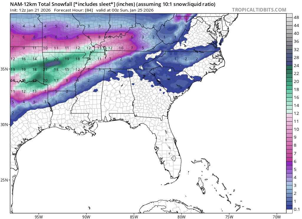
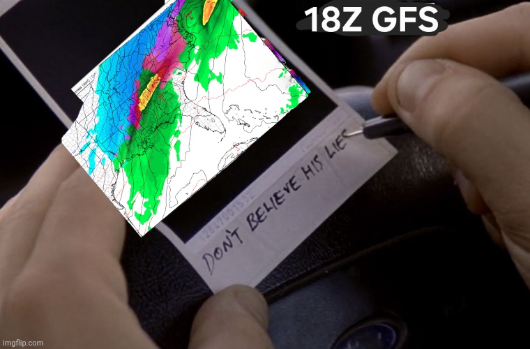
How I am feeling about the trends on the 18z GFS:
-
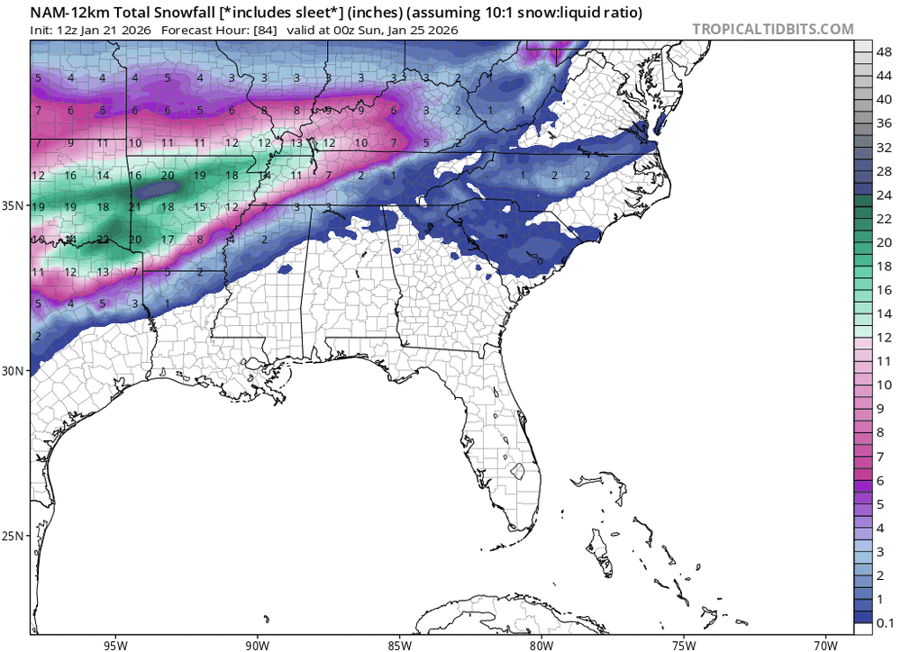
I will take the better low placement regardless! I still think Euro is too warm. Wonder if we will see a sort of middle ground develop between models. Honestly anything but inches of ice would be nice at this point.
-
Looks like surface temps are closest to the GFS at this point.
-
Only to 78 hours here, but a good trend based on surface output. Ignore the numbers as this is probably sleet.
-
I think that makes sense. Temps on Euro are straight up hot. I think even the Canadian is more realistic with temps with a similar storm track.
-
Wait, so a surface low off the gulf and off the coast per GFS? How common is that? Man, this looks complicated. No wonder for the yoyo results.
-
Pardon my ignorance, but I simply assumed the NMB was literally just solutions averaged out? Is it something else? Because I really don't understand how we are averaging this much snow still with some pretty big misses on some of the bigger models.
-
Yeah, don't think it plays out like that. Like it could rain, mix, dry slot, whatever, but that high magically weakening 10mb unlike every other model does not make any sense. Feel like other mechanisms of lower totals are way more plausible.
-
Agreed on the monster. At this point, while I would absolutely love all snow, I am just preparing for a major event. Seems like we will have a substantial amount of precipitation and cold, just a matter of what type. Prolonged subfreezing temps and 1 to 2 inches of liquid will grind things to a halt here for a bit.