Silas Lang
-
Posts
761 -
Joined
-
Last visited
Content Type
Profiles
Blogs
Forums
American Weather
Media Demo
Store
Gallery
Everything posted by Silas Lang
-
Honestly with the CMC being on the fringe of the snow line in the middle of the state (I-40ish) and the GFS going south of I-40, you have to think as a whole, TN is in a pretty good spot for a big hit. So long as things dont trend too much in one direction.
-
Goodness. I don't have time to dive into the differences in the 12z and 18z euro. Looks like the system is slower on the 18z? What is causing this? Forum area is pasted and still snowing across the state?!
-
December 11th - 12th clipper potential
Silas Lang replied to Holston_River_Rambler's topic in Tennessee Valley
Got some light flakes here in Knoxville (Inskip neighborhood). -
February 19-20 Major Winter Storm Threat
Silas Lang replied to NorthHillsWx's topic in Southeastern States
LOL that's just probability for an inch, FYI. -
No, fortunately house is fine. It is in a relatively good spot. Not so good for the neighbors though. No damage, but it is concerning for future events. Especially the old lady across the street whose house is on concrete slab. We are a good 3 feet off the ground here (crawlspace) and the water runs away from the house. Starting to do it again. Last I checked we had 1.20 for the day here. Similar to yesterday.
-
Yeah, and additionally the storms last Thursday night flooded some areas already. I received 2 inches in a hour. I know that didn't include all of Knoxville or the area, but places that got hit by that line have some pretty saturated grounds. Was the worst flooding I had seen at my house in 6 years I have lived here.
-
Just another reason it so important for MRX to put out those statements and weather products: school districts rely on them. I have noticed schools are way more likely close with some sort of product or statement issued. Of course, you could always ignore them like Knox County did this week.
-
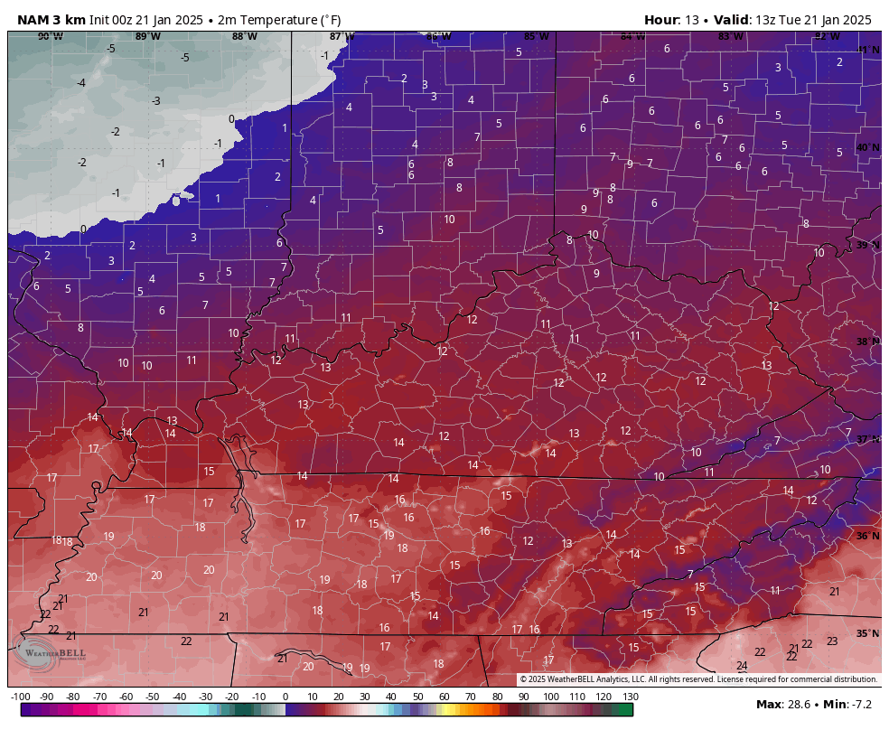
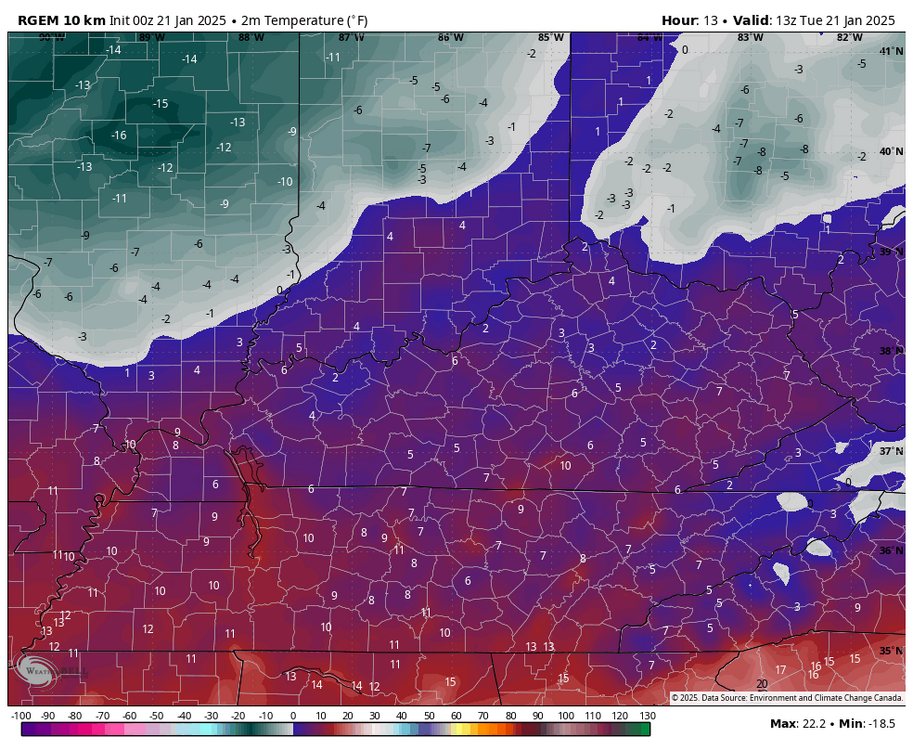
Same here. At 11 now. They must have been riding with the NAM. RGEM looks more realistic with possible lows in the AM. NAM is already busted.

- 207 replies
-
- 1
-

-
- obs
- light snow
- (and 2 more)
-
Bottomed out at 10. Up to a toasty 13 now. Staring at my deck in the sun and you can literally watch as the snow melts and turns into ice. While the sun is doing it's job there is no dripping. Be safe out there!
-
Man everything is white here now. Really surprised by this. The stream down 75 has been legit going down into Knoxville.
- 207 replies
-
- 3
-
-
- obs
- light snow
- (and 2 more)
-
Was at 34 and just dropped to 33 with heavy burst of snow. Everything getting white quick. Heavier snow than I saw with the last system. lol
- 207 replies
-
- 3
-
-
- obs
- light snow
- (and 2 more)
-
Upon review, a bit of dry air at the 850 and 925 levels, but looks pretty juiced above that. On the 18z GFS.
- 207 replies
-
- 3
-

-
-
- obs
- light snow
- (and 2 more)
-
Kind of where I am. How many times have we seen that finger of moisture pop up on systems like this? Right up the valley and spine of the apps. There upper level moisture doesn't look too bad either or least it didn't yesterday.
- 207 replies
-
- 4
-
-
- obs
- light snow
- (and 2 more)
-
I wouldn't necessarily punt on Tuesday. The GFS is almost to where the Canadian is now. Yet another move NW from 0z to 6z. Euro trending NW as well.
-
Yeah, trends for mid week are actually great on the GFS past few runs. Getting closer to Canadian.
-
Yeah, kind of nuts here in Knoxville. Most open exposed areas are clear, but anywhere in the shade still has plenty of snow. Driving around town yesterday, North facing hills still look relatively untouched. Felt bad for a few snowy, hilly driveways. I took my dog for a walk in the park and the snow that is hanging around is tough crusty stuff. Felt like I barely made an imprint and I am a 200 pound man. lol
-
Euro was tasty. I was thinking the same thing. No way that HP verifies. That has to be good of us though, seeing how the GFS has the storm to our south and east. Just hope it doesn't weaken too much and trend too far north.
-
Surprised at how good the under the radar, backside snow is. Small flakes, but pretty steady and easily visible. Usually have to squint real hard to see it at night. lol
-
Yeah, similar results here. Hard to complain. Pretty impactful winter storm! Snow, sleet, and freezing rain. No joke and a worthy storm for the record books.
-
lol I don't understand it all either, but it is fun to try. Here is a gif of those wind speeds mentioned in the message that is helping keep some precip around.
-
Interesting update from MRX. CONUS view infrared satellite imagery shows the beginning stages of a baroclinic leaf forming to our northeast in response to an absolutely screaming H3 (forecast to exceed 180kt by a multitude of guidance sources later tonight) that is developing from central MS/AL northeast through east TN and the mid-Atlantic seaboard. This jet, which overlaps our CWA, is aiding in the continuation of stratiform light precip over areas north of I-40 and east of the I-75 corridor from Knoxville to the Kentucky border. This large scale ascent is counteracting the drying that is trying to occur aloft, specifically in the DGZ, which has lead to an oscillation back and forth between periods of snow and drizzle/freezing drizzle like you would expect when losing saturation within the dendritic growth zone. That said, the last hour or so, it seems the large scale forcing is winning out. As such, would expect to see stratiform light snow continue over the areas outlined above for the next 3-4 hours. After that time the jet is forecast to be far enough east that we lose synoptic support for the stratiform precip. Radar imagery already shows this, with the back edge of the precip almost through La Follette, Oak Ridge, and Tellico Plains. After the stratiform precip ends by roughly Midnight let`s say, we`ll transition to a NW flow regime, where most all precipitation will be confined to the mountains. Updated PoPs to reflect these trends.
-
Yup. Very tiny drops falling fast here. Deck already an ice ring where I cleaned off a spot. Nasty at 28 degrees.
-
I think there is plenty of time for more. Don't know if we will get those higher totals. But, still a good event, imo.
-
Been ripping the past hour. Eyeball test is around 2 inches or so. Remaining steady at 28.
-
Yessir. Starting to pick up here now!