Silas Lang
-
Posts
761 -
Joined
-
Last visited
Content Type
Profiles
Blogs
Forums
American Weather
Media Demo
Store
Gallery
Everything posted by Silas Lang
-
January 15th-17th 2024 Arctic Blast/Snow Event
Silas Lang replied to John1122's topic in Tennessee Valley
I heard it too. -
January 15th-17th 2024 Arctic Blast/Snow Event
Silas Lang replied to John1122's topic in Tennessee Valley
I am just starting to come to the realization that this could potentially happen... We are almost with the 3 day mark. Short range models are picking it up now. The storm today will be out of the way tonight and we should start having the energy sampled properly on the West Coast. If we can stay locked in today and tomorrow, we could have something historic. -
January 15th-17th 2024 Arctic Blast/Snow Event
Silas Lang replied to John1122's topic in Tennessee Valley
Euro trend:
-
January 15th-17th 2024 Arctic Blast/Snow Event
Silas Lang replied to John1122's topic in Tennessee Valley
Euro took a NW jog of about 50 miles. Big difference in results. And the storm is not even finished at 90 hours. Man, that makes me feel better about this. It's coming more in line with other guidance. -
January Medium-Long Range Discussion
Silas Lang replied to Holston_River_Rambler's topic in Tennessee Valley
This is snow total for the Friday storm.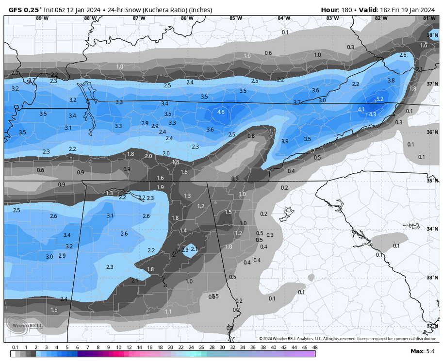
-
January Medium-Long Range Discussion
Silas Lang replied to Holston_River_Rambler's topic in Tennessee Valley
6z GFS looks close to delivering next Friday. Big improvement over 0z. -
January 15th-17th 2024 Arctic Blast/Snow Event
Silas Lang replied to John1122's topic in Tennessee Valley
Let's all appreciate this possible solution. Think everyone would be happy with this!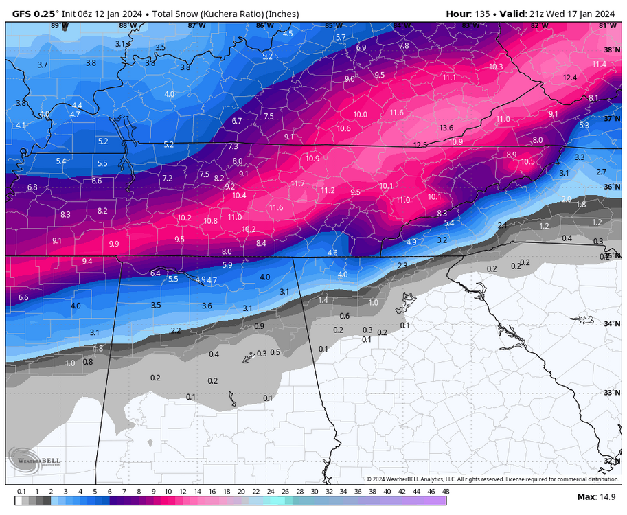
-
January 15th-17th 2024 Arctic Blast/Snow Event
Silas Lang replied to John1122's topic in Tennessee Valley
This weather could be historic regardless of snow. I don't know what the record is for staying below freezing is in Tennessee, but I have think what the GFS is showing is a pretty big deal. I can remember maybe 3 days below freezing in a row. Nuts what is being advertised. We are not ready or equipped for this! -
January Medium-Long Range Discussion
Silas Lang replied to Holston_River_Rambler's topic in Tennessee Valley
Yup, it was on the GFS and CMC. Didn't pop on GFS, but man, the potential is there. Would be insane to have a chance to score snow on snow. -
January 15th-17th 2024 Arctic Blast/Snow Event
Silas Lang replied to John1122's topic in Tennessee Valley
At this point I would rather take my chances with the moisture a la the CMC. I think the cold air will be legit. The Euro was anemic on moisture, which is my worst fear: cold and dry. -
January 15th-17th 2024 Arctic Blast/Snow Event
Silas Lang replied to John1122's topic in Tennessee Valley
Honestly looks like an in between of the 18z GFS and 12z Euro, clown map wise. -
January 15th-17th 2024 Arctic Blast/Snow Event
Silas Lang replied to John1122's topic in Tennessee Valley
Definitely a noticable jump southeast. -
January 15th-17th 2024 Arctic Blast/Snow Event
Silas Lang replied to John1122's topic in Tennessee Valley
What are the implications of this? -
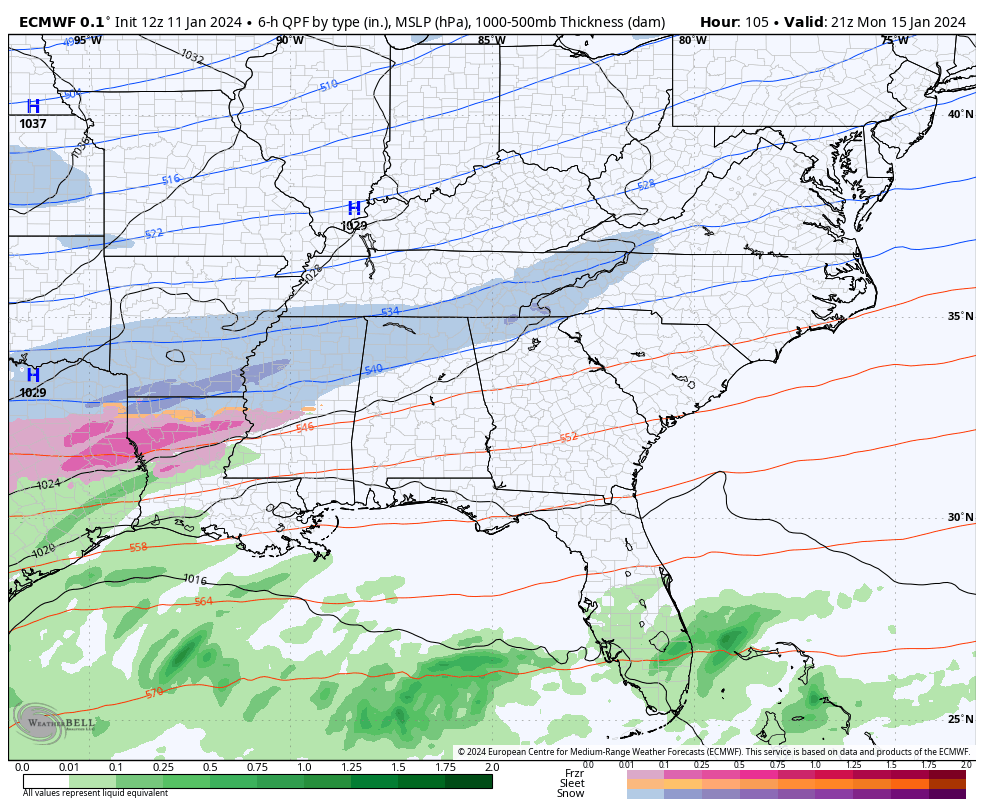
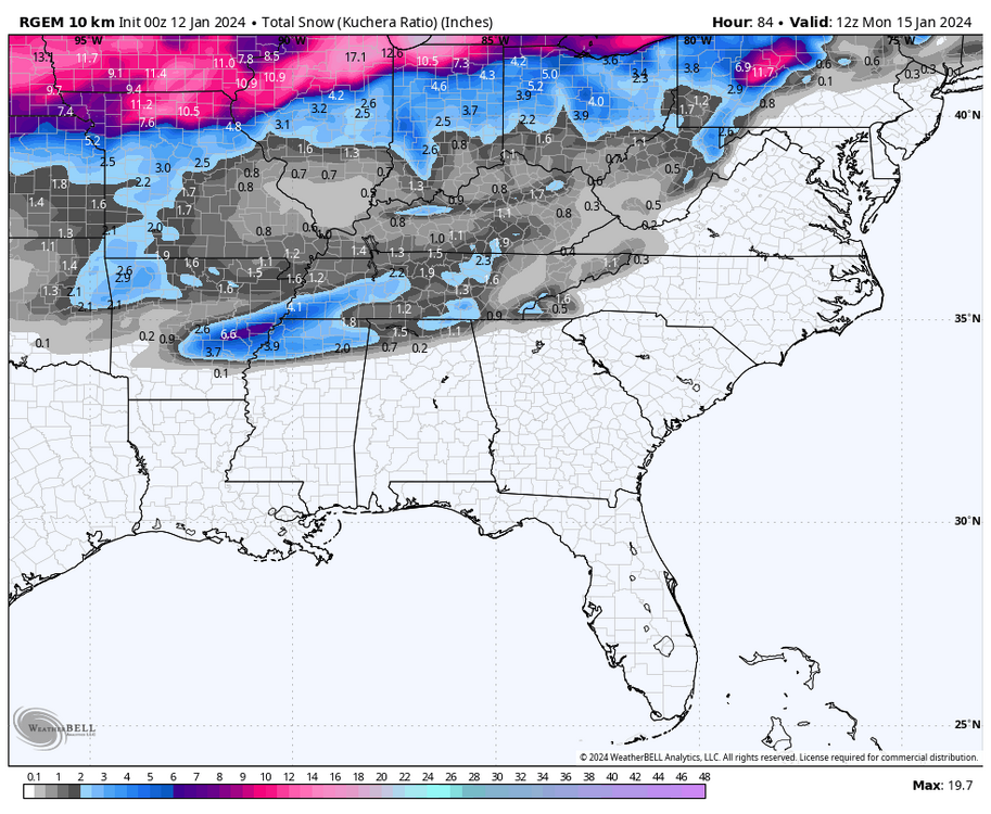
January 15th-17th 2024 Arctic Blast/Snow Event
Silas Lang replied to John1122's topic in Tennessee Valley
If anyone is interested in extrapolating from 84 hours on the RGEM, here ya go. lol
-
January 15th-17th 2024 Arctic Blast/Snow Event
Silas Lang replied to John1122's topic in Tennessee Valley
It at least still shows a push to the east as well, suggesting we get in on some of the initial action. Though it does look like some downsloping is evident, especially in the southern valley. -
January 15th-17th 2024 Arctic Blast/Snow Event
Silas Lang replied to John1122's topic in Tennessee Valley
I like this. Acknowledged the threat and pretty transparent. 2" is a "good" snow for me, so if I can get that, I am satisfied. Of course, more is always welcome! Haha -
January 15th-17th 2024 Arctic Blast/Snow Event
Silas Lang replied to John1122's topic in Tennessee Valley
Thanks for this. I hope there is a way we can all score here. Anyone have any recent examples of similar storms? Just want to know what "success" would look like or if it is even possible or likely. -
January 15th-17th 2024 Arctic Blast/Snow Event
Silas Lang replied to John1122's topic in Tennessee Valley
Anyone have any thoughts on the 18z Euro? I know it doesn't go out far, but curious if it looked better for us. I am not good at reading those vort maps, so I can't really tell. -
January 15th-17th 2024 Arctic Blast/Snow Event
Silas Lang replied to John1122's topic in Tennessee Valley
Man, that looks tasty. Something like that looks like it could nail the whole state pretty well, including Chattanooga. I am nervous about that second wave approach that 18z GFS advertised for the East. Would much rather get involved in the initial wave (like the RGEM shows) and go from there. -
January 15th-17th 2024 Arctic Blast/Snow Event
Silas Lang replied to John1122's topic in Tennessee Valley
I don't know. Euro looks pretty odd. I don't think it will be the ultimate solution, but certainly a possibility I guess. Still, one would have to think that even with limited precipitation, the snow totals would be higher. That is some cold air and will squeeze ever drop out. -
January 15th-17th 2024 Arctic Blast/Snow Event
Silas Lang replied to John1122's topic in Tennessee Valley
Phew. Looks more and more likely the state will be crippled with cold and some kind of frozen precipitation. How much seems to be the question now. -
January 15th-17th 2024 Arctic Blast/Snow Event
Silas Lang replied to John1122's topic in Tennessee Valley
Yeah stronger push from the artic air this run. A jog south and east. -
January 15th-17th 2024 Arctic Blast/Snow Event
Silas Lang replied to John1122's topic in Tennessee Valley
Also, hasn't the Euro been under performing on precipitation this season so far? With this last storm I was projected to get around 1.5 inches of rain and ended up with 2.5. One can only hope that trend continues next week. -
January Medium-Long Range Discussion
Silas Lang replied to Holston_River_Rambler's topic in Tennessee Valley
This is why I was a bit confused at the 0z GFS run yesterday. That super frigid air meeting the warm Gulf has to result in something, right? -
January Medium-Long Range Discussion
Silas Lang replied to Holston_River_Rambler's topic in Tennessee Valley
Looks like we are back in business with 0z Euro and 6z GFS. Both seem to string out the moisture a bit.