Silas Lang
-
Posts
761 -
Joined
-
Last visited
Content Type
Profiles
Blogs
Forums
American Weather
Media Demo
Store
Gallery
Everything posted by Silas Lang
-
March 11th-13th Winter Weather Event. Winter's last gasp?
Silas Lang replied to Windspeed's topic in Tennessee Valley
I know I said I was going to sleep but the temp has fallen drastically. Now at 44. Been 15 minutes. -
March 11th-13th Winter Weather Event. Winter's last gasp?
Silas Lang replied to Windspeed's topic in Tennessee Valley
50 degrees with sprinkles here. Wind ripping. Front coming through. High of 69 degrees. Let's do this. Reporting back at 4 am. -
March 11th-13th Winter Weather Event. Winter's last gasp?
Silas Lang replied to Windspeed's topic in Tennessee Valley
Yeah after reviewing the models, me and my wife are too lol And dog as well. -
March 11th-13th Winter Weather Event. Winter's last gasp?
Silas Lang replied to Windspeed's topic in Tennessee Valley
What time is the heaviest rates of snow coming through Knox? Like 3 am or 4 am? Going to wake up for it because... -
March 11th-13th Winter Weather Event. Winter's last gasp?
Silas Lang replied to Windspeed's topic in Tennessee Valley
With how the models have been under doing the snow out west and with the high totals showing up on the models east... I think someone is going to get close to a foot tonight. Things have been busting high so ... add a couple inches to some of those high totals and... -
March 11th-13th Winter Weather Event. Winter's last gasp?
Silas Lang replied to Windspeed's topic in Tennessee Valley
Is there some kind of valley enhancement going on? I kind of jokingly asked about it earlier, but this run it seems super prominent. Notice how the snow is not elevation dependent here. EDIT: you can really see it on the 3k NAM. -
March 11th-13th Winter Weather Event. Winter's last gasp?
Silas Lang replied to Windspeed's topic in Tennessee Valley
HRRR for those who want it.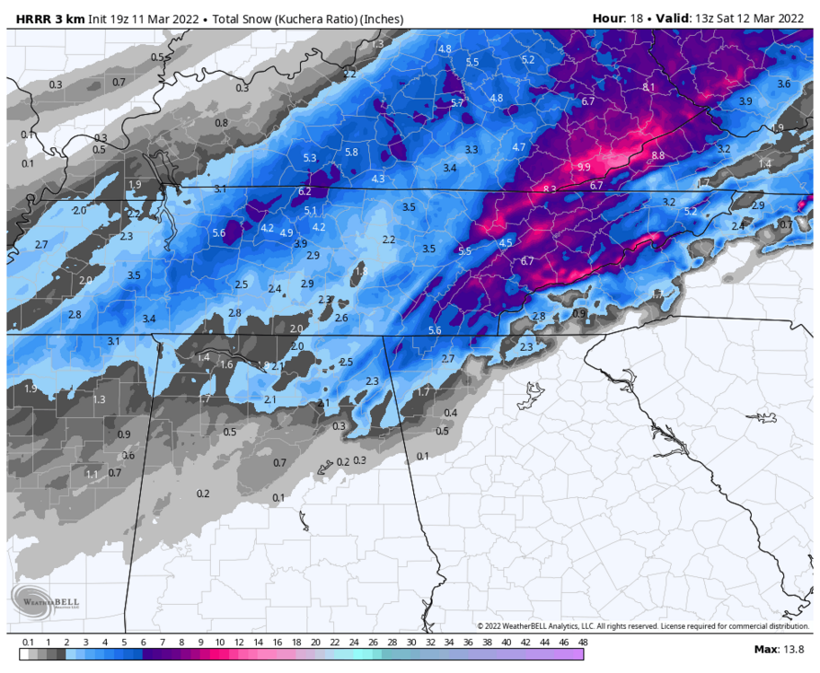
-
March 11th-13th Winter Weather Event. Winter's last gasp?
Silas Lang replied to Windspeed's topic in Tennessee Valley
When is the last time that happened? Usually it's the ole Lucy with the football situation. -
March 11th-13th Winter Weather Event. Winter's last gasp?
Silas Lang replied to Windspeed's topic in Tennessee Valley
My forecast now has 2 to 4 overnight and 1 to 2 on Saturday morning. So 3 to 6 overall. -
March 11th-13th Winter Weather Event. Winter's last gasp?
Silas Lang replied to Windspeed's topic in Tennessee Valley
You afraid of getting kicked somewhere? I don't know if you noticed, but on both runs of the 3k there is a little purple streak going up the central valley. Some kind of valley enhancement? -
March 11th-13th Winter Weather Event. Winter's last gasp?
Silas Lang replied to Windspeed's topic in Tennessee Valley
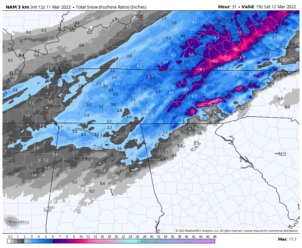
3k the same. 18z top 12z bottom Looks like John gets smacked hard on this run.

-
March 11th-13th Winter Weather Event. Winter's last gasp?
Silas Lang replied to Windspeed's topic in Tennessee Valley
I know we are pretty much into nowcasting time, but the NAM is looking fat and beefy. Big improvement over 12z. 12z for comparison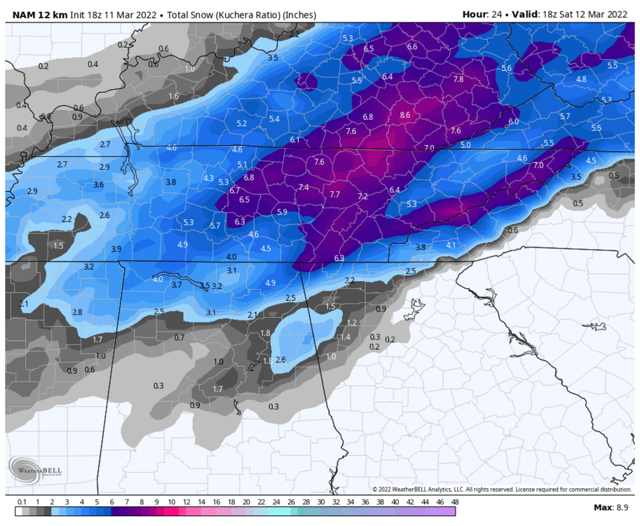

-
March 11th-13th Winter Weather Event. Winter's last gasp?
Silas Lang replied to Windspeed's topic in Tennessee Valley
Wow, I was looking at Knoxville and that is a GREAT looking SREF plume. Lowest is a tight cluster around 2.5 inches, which is a great bottom to have. Two over a foot! A small cluster around 10 inches with a majority between 5 and 7. Haven't seen one that good in years. -
March 11th-13th Winter Weather Event. Winter's last gasp?
Silas Lang replied to Windspeed's topic in Tennessee Valley
It's a cold 65 here now. And I mean that. Despite the warmth, the wind is pretty chilly! -
March 11th-13th Winter Weather Event. Winter's last gasp?
Silas Lang replied to Windspeed's topic in Tennessee Valley
Something else to consider is the precipitation trends. This storm is slowing becoming less rain and more snow as well.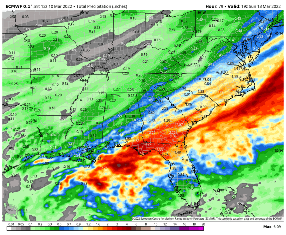
.thumb.png.f0ffdb5e4097308dd7af8edbf4230d42.png)
.thumb.png.51172c56188fac4122466e411f923d7b.png)
.thumb.png.64bbe54423f6010d82d0cebfc65b9d7b.png)
-
March 11th-13th Winter Weather Event. Winter's last gasp?
Silas Lang replied to Windspeed's topic in Tennessee Valley
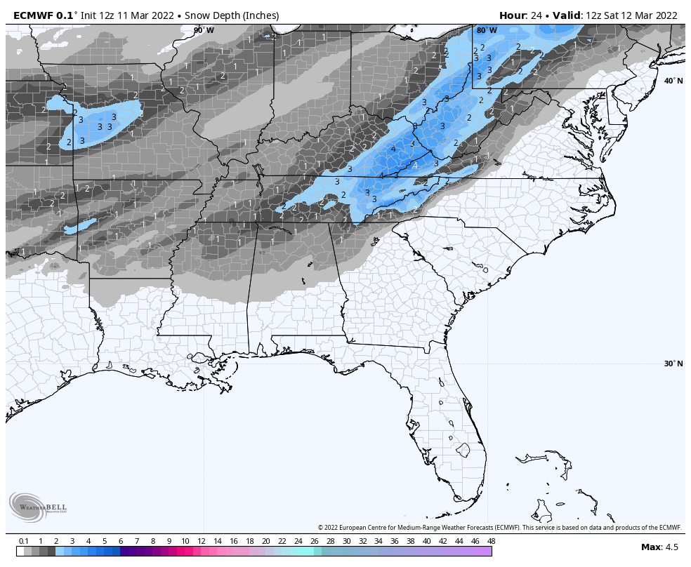
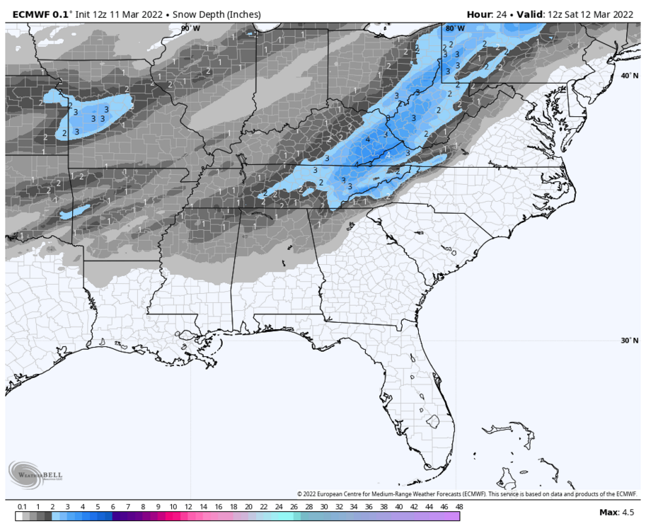
A little bit of correction in snow totals in AR, but the depth maps show there is less than is actually there! This is suggesting most of the snow is not having a problem sticking. 12z holds for most.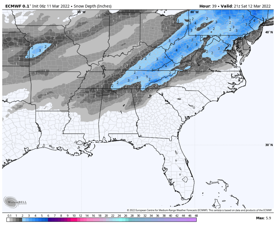


-
March 11th-13th Winter Weather Event. Winter's last gasp?
Silas Lang replied to Windspeed's topic in Tennessee Valley
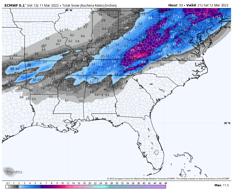
While waiting for the Euro, let's look at the last run. I was looking at the snow depth versus snowfall. I know this is a concern (melting snow, warm ground, etc). If NW Arkansas has spots of 4 inches this thing is a big over performer. Below is the snowfall (total snow) versus depth. The depth should be light in AK right now according to the Euro. Like 1 inch max. There is a little more total snow on the snow map (2.5 inches), but it is still not as much as the reports. Curious to see what the 12z shows to compare. Correction incoming?
-
March 11th-13th Winter Weather Event. Winter's last gasp?
Silas Lang replied to Windspeed's topic in Tennessee Valley
What was initially modeled for that region AK? Going to be interested to see how this thing develops, especially in the daytime. That sun is intense. Warm outside in the sun, but as soon as cloud cover happens it feels cool enough for a jacket with the wind. Encouraging to see strong totals. -
March 11th-13th Winter Weather Event. Winter's last gasp?
Silas Lang replied to Windspeed's topic in Tennessee Valley
It really is coming in at the perfect time. The ground has several hours without direct sunlight before the snow starts. The sun is the real killer this time of year. I am curious how fast this all melts. -
March 11th-13th Winter Weather Event. Winter's last gasp?
Silas Lang replied to Windspeed's topic in Tennessee Valley

-
March 11th-13th Winter Weather Event. Winter's last gasp?
Silas Lang replied to Windspeed's topic in Tennessee Valley
Still a solid hit though. 3k still loading. May be a bit better. -
March 11th-13th Winter Weather Event. Winter's last gasp?
Silas Lang replied to Windspeed's topic in Tennessee Valley
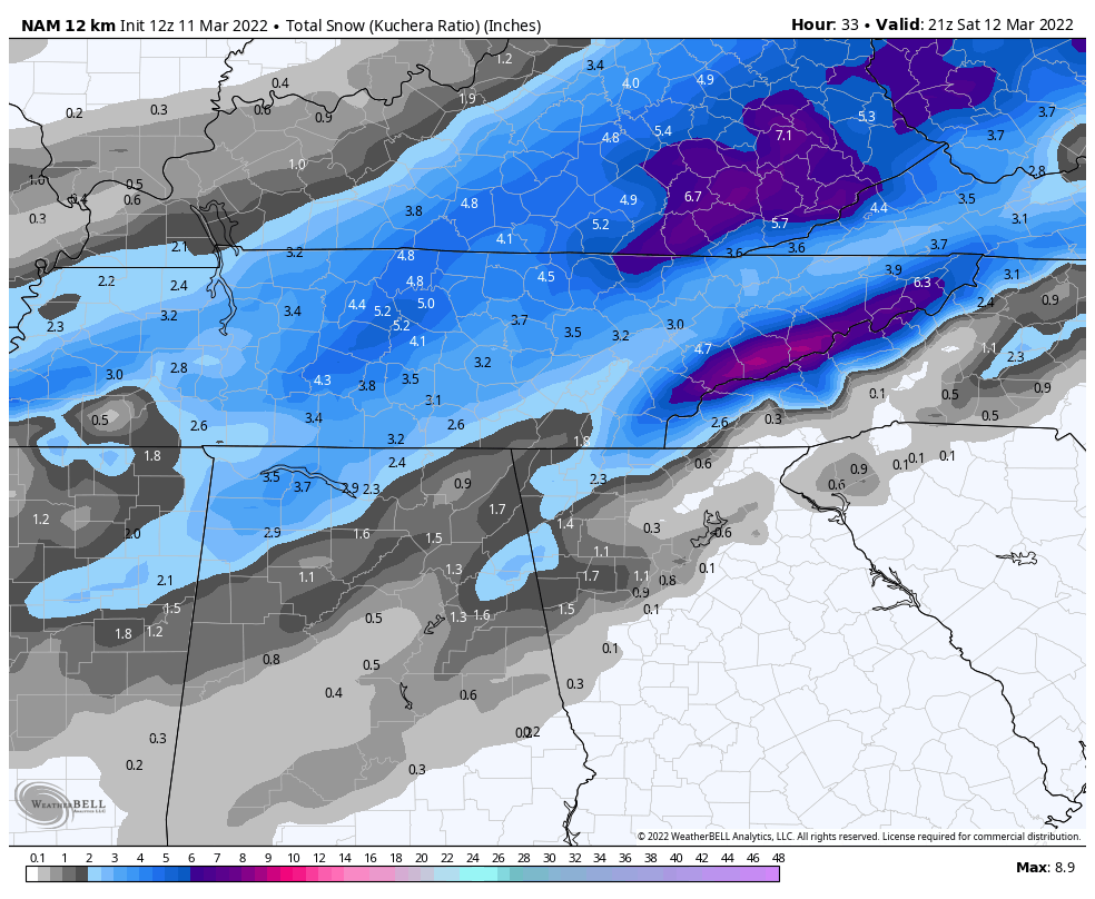
NAM seems to be showing less precip and looking weaker.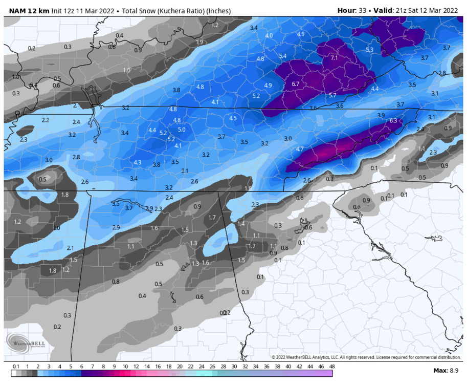
-
March 11th-13th Winter Weather Event. Winter's last gasp?
Silas Lang replied to Windspeed's topic in Tennessee Valley
I am in Inskip right next to Fountain City. It is interesting how these ridges factor into our weather. While not 8 degrees colder, it is typically colder here as well and I have noticed sometimes "north of 40" really sort of equates to north of Sharp's ridge here locally as it does sometimes seem to impact precipitation and temps. Halls definitely fits in with that climo. You are right on the door step of Big Ridge. Love going up there! Probably one of my favorite parks as it is not usually crowded. -
March 11th-13th Winter Weather Event. Winter's last gasp?
Silas Lang replied to Windspeed's topic in Tennessee Valley
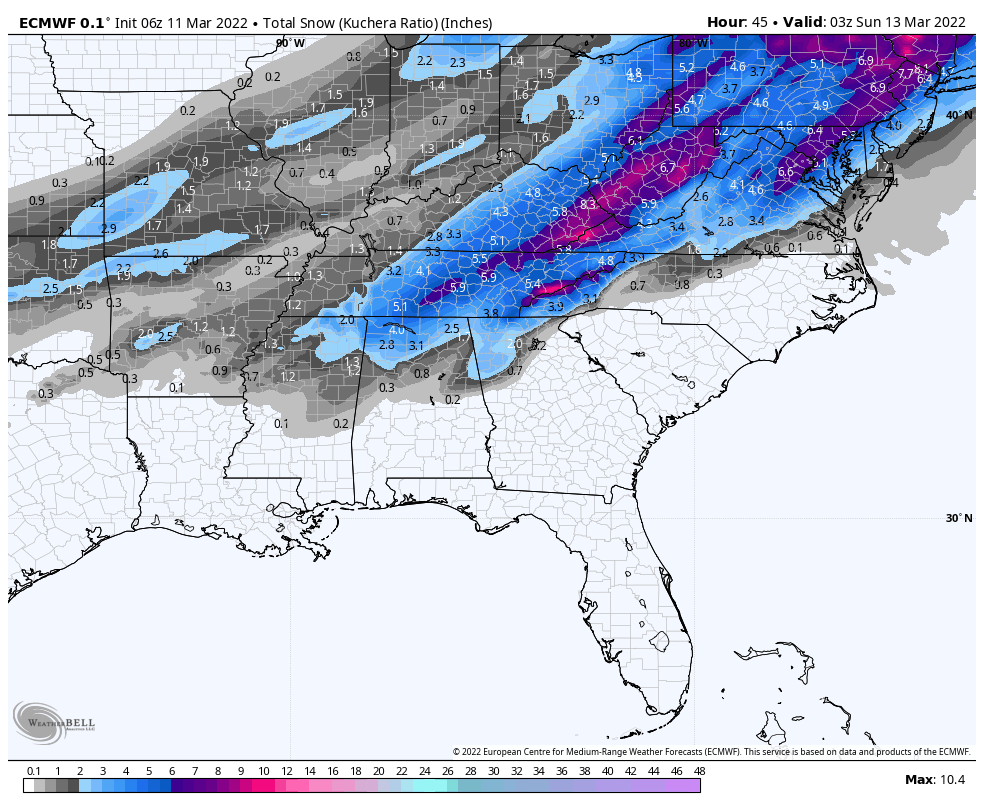
Looks like Euro is holding with it's heavier totals from 0z. Remember, it was showing an average of a one to two inches lighter totals until last night.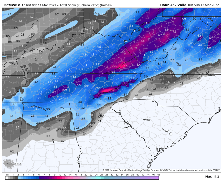
-
March 11th-13th Winter Weather Event. Winter's last gasp?
Silas Lang replied to Windspeed's topic in Tennessee Valley
1" for tonight and 1" for tomorrow for mine. I don't really don't know what factors into that forecast. Maybe they are relying on warm ground temperature? Your forecast is about right. NMB has a solid 4 for Knox. You can be the scapegoat if this doesn't work out. Lol But seriously, glad to have your obs in Morgan for this one.


.png.06ae7a44b973278ce238124ebe748f39.png)
.png.b2e00408db1ab92d53dbaee80ac21e91.png)
.png.2d426a7f0d699f5a5de90e499adaddda.png)