

Silas Lang
-
Posts
761 -
Joined
-
Last visited
Content Type
Profiles
Blogs
Forums
American Weather
Media Demo
Store
Gallery
Everything posted by Silas Lang
-
Historic Christmas Cold & maybe snow?! Dec 23rd-30th
Silas Lang replied to Wurbus's topic in Tennessee Valley
Looks like a back end mood flake setup for the valley. -
Historic Christmas Cold & maybe snow?! Dec 23rd-30th
Silas Lang replied to Wurbus's topic in Tennessee Valley
Less cutting and more coastal this go around -
Fall/Winter Banter - Football, Basketball, Snowball?
Silas Lang replied to John1122's topic in Tennessee Valley
WHY ARE WE YELLING? But, seriously this account just took the 6z GFS run and stated it as a forecast. Which is the problem with these accounts. -
Historic Christmas Cold & maybe snow?! Dec 23rd-30th
Silas Lang replied to Wurbus's topic in Tennessee Valley
Agreed on having the thread. Boom or bust, it is nice to have to reference. Besides, not like we get many shots some years. May as well enjoy what we get...or don't get! -
Historic Christmas Cold & maybe snow?! Dec 23rd-30th
Silas Lang replied to Wurbus's topic in Tennessee Valley
Latest GFS was much better for West and Middle TN. A little concerning for the valley with the LP sitting right on top of it at one point. Still managed to get most of the state. Storm more wound up. Seems like it took a step towards the Euro/CMC. Not a good trend, imo as the storm could end up cutting more if it continues. -
Historic Christmas Cold & maybe snow?! Dec 23rd-30th
Silas Lang replied to Wurbus's topic in Tennessee Valley
The GFS has scored some wins the past year or so since the major upgrade, correct? Maybe I am remembering it wrong, but I swear it has seemed more consistent for the past couple of big winter storms. -
December 2022 Medium/Long Range Pattern Discussion Thread
Silas Lang replied to Carvers Gap's topic in Tennessee Valley
My only concern is that systems get crushed by the cold. Is that a possibility? Or are there other dynamics at play from preventing that outcome?- 582 replies
-
- 1
-

-
- snow
- freezing rain
- (and 4 more)
-
December 2022 Medium/Long Range Pattern Discussion Thread
Silas Lang replied to Carvers Gap's topic in Tennessee Valley
Obviously one run, but this would have to be a record week for East TN if it did occur. Just nuts. While I don't expect this to come to fruition, I do think this does highlight that we have a genuine shot of a great couple of weeks of winter. And yeah, not overrunning, but not sure what you call those events that happen after Christmas. I think I will just go with amazing. lol- 582 replies
-
- 1
-
-
- snow
- freezing rain
- (and 4 more)
-
December 2022 Medium/Long Range Pattern Discussion Thread
Silas Lang replied to Carvers Gap's topic in Tennessee Valley
A gif for those unable to look at the moment.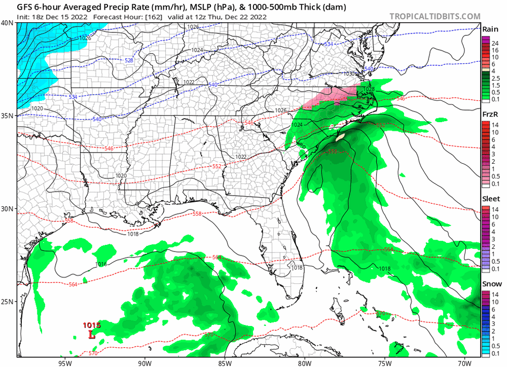
- 582 replies
-
- 8
-
-

-
- snow
- freezing rain
- (and 4 more)
-
December 2022 Medium/Long Range Pattern Discussion Thread
Silas Lang replied to Carvers Gap's topic in Tennessee Valley
Another big hit!- 582 replies
-
- 6
-
-
- snow
- freezing rain
- (and 4 more)
-
December 2022 Medium/Long Range Pattern Discussion Thread
Silas Lang replied to Carvers Gap's topic in Tennessee Valley
Goodness, I didn't get a chance to check the rest of that GFS until now. Bone chilling temps and some snow showers and another storm trying to pop ( a little late for us) on the 27th. It is below freezing for almost a week as well.- 582 replies
-
- 2
-
-
- snow
- freezing rain
- (and 4 more)
-
December 2022 Medium/Long Range Pattern Discussion Thread
Silas Lang replied to Carvers Gap's topic in Tennessee Valley
Yeah, I noticed that wave holding together a little better as well. Need to keep an eye on it. Would be nice to get some snow on snow with the Christmas Eve storm as well. I can't remember how long it has been since we have had snow fall on snow in the valley. Maybe 2013 or 2014?- 582 replies
-
- 4
-
-
-
- snow
- freezing rain
- (and 4 more)
-
December 2022 Medium/Long Range Pattern Discussion Thread
Silas Lang replied to Carvers Gap's topic in Tennessee Valley
There was also a pretty tight East to West gradient for this storm as well. I stayed at my folks in Anderson County and they got about 2 inches while the totals got higher as drove back to my place in Knox. We had 5 inches at the house. That was pretty surprising.- 582 replies
-
- 3
-
-
- snow
- freezing rain
- (and 4 more)
-
December 2022 Medium/Long Range Pattern Discussion Thread
Silas Lang replied to Carvers Gap's topic in Tennessee Valley
Well, this pattern is certainly ripe for some surprises. I've been caught up with the Christmas period and the 18z GFS says, what about next week instead? Seriously seems like something could easily pop up in a few days notice. Not too concerned about details as it seems to be in flux from run to run. Hopefully we can all score the next couple of weeks!- 582 replies
-
- 3
-
-
- snow
- freezing rain
- (and 4 more)
-
Yeah, it has been nonstop flashbulbs. Coming up on 3 inches of water. Real impressive storm. My yard is a lake. And it looks like there is a stout line coming in behind it. You should be seeing that soon. What is the cause of this? The flow? Like the opposite of a rain shadow or something.
-
Anyone else been under this neverending cell in Anderson/Knox? Two hours and this little storm is still kicking. Already two inches of rain and a flood warning.
-
Yeah, we are due for a dry year. Sucks, as I much rather be too wet than too dry. I am currently watching that little break and hoping it fills in. My yard desperately needs rain at the moment (as I am sure most people's yards here need). I did manage a whooping .01 this morning. Hope it fills in or manages a little back build for you.
-
Today we had the most rain in a while in Knoxville. Also, the best thunder and lightning of the season this far. Saw a few huge bolts this morning. Think one struck very close to work. Last few storm threats have been mostly wind here, so it was a nice change of pace.
-
There is a fire in Anderson County across from my parent's place currently.
-
March 11th-13th Winter Weather Event. Winter's last gasp?
Silas Lang replied to Windspeed's topic in Tennessee Valley
My station reads a low of 12 this morning. My totals for the year are at 12 inches. Well above average due to this storm. Not sure how to rate the winter overall. January was great with a bunch of smaller events and cold. This storm was of course amazing, making it an excellent March. But December and February were terrible for snow lovers in the valley. However, the results don't lie so I have to give this Winter an A. It is something to think about when looking at the historical record. An awesome winter on paper still can have stretches of warm and snowlessness. Anyway, bring on the spring. I am ready for it now. I will see you guys next season. It has been fun! -
March 11th-13th Winter Weather Event. Winter's last gasp?
Silas Lang replied to Windspeed's topic in Tennessee Valley
Just cleaned off the cars and did some shoveling. You can tell this is some high ratio stuff. Easy to move like light sand or something. Going to be a tough shell by tomorrow morning.. And now this little snow shower is already trying to cover it up again. -
March 11th-13th Winter Weather Event. Winter's last gasp?
Silas Lang replied to Windspeed's topic in Tennessee Valley
Looks like the snow has stopped. Ended with 7 inches. Not bad for mid March! I got more snow today than the previous events combined. -
March 11th-13th Winter Weather Event. Winter's last gasp?
Silas Lang replied to Windspeed's topic in Tennessee Valley
Probably on average around 6.5 inches. I did also measure some random spots of 7.5 to 8 inches out in the yard as well. Wind drifts? There are few seemingly random larger piles of snow out there along with some smaller ones, around 5 inches or so. Seems it got blown around some. Pretty awesome event! A nice little Jr. 93 here. Beautiful snow coming down right now. Maybe another inch? Edit: enjoy the dog nose.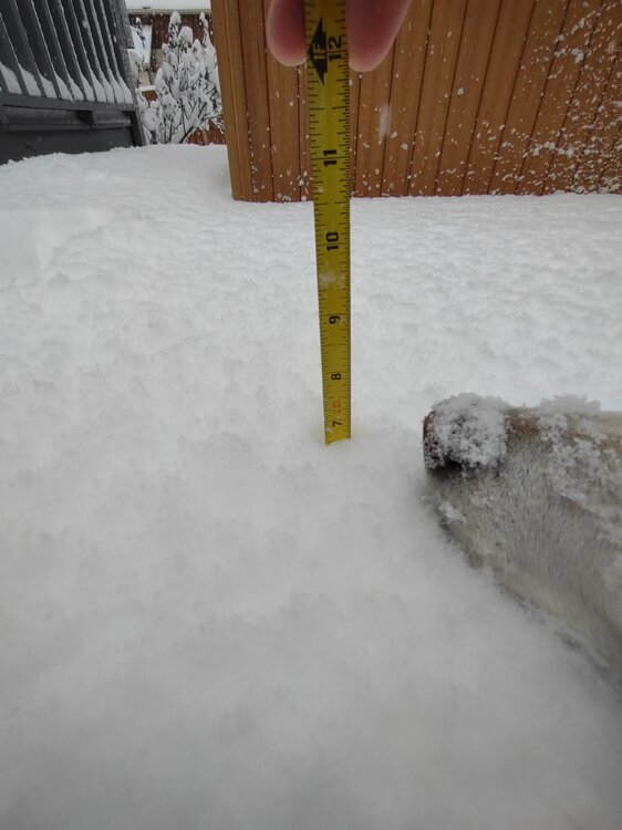
-
March 11th-13th Winter Weather Event. Winter's last gasp?
Silas Lang replied to Windspeed's topic in Tennessee Valley
About to step with dog for the last band. When I checked a few hours ago, I was at a little over 3. -
March 11th-13th Winter Weather Event. Winter's last gasp?
Silas Lang replied to Windspeed's topic in Tennessee Valley
At least 3 inches here. It is thick! Some spots show more.

