

Silas Lang
-
Posts
761 -
Joined
-
Last visited
Content Type
Profiles
Blogs
Forums
American Weather
Media Demo
Store
Gallery
Everything posted by Silas Lang
-
March 11th-13th Winter Weather Event. Winter's last gasp?
Silas Lang replied to Windspeed's topic in Tennessee Valley
Carver, is there anything to keep this from going more NW? I've noticed the stronger trend and am kind of worried about an Ohio valley special. A few more ticks west and we could looking at rain. But yeah, it did look like the east was about to get hammered on the 18z and ensemble support is increasing so not really sure at this point. This has the makings of a great storm for the valley if holds. -
March 11th-13th Winter Weather Event. Winter's last gasp?
Silas Lang replied to Windspeed's topic in Tennessee Valley
Wow, that's a solid 4+ inches for East TN and an overall statewide hit. This is definitely the most impressive ensemble support I have seen all winter for a storm. -
March 11th-13th Winter Weather Event. Winter's last gasp?
Silas Lang replied to Windspeed's topic in Tennessee Valley
Wow, the LP looked stronger this run. I guess we don't want it to strengthen too much or it could cut on the other side of the mountains, correct? Is there there anything keeping this from happening? -
March 11th-13th Winter Weather Event. Winter's last gasp?
Silas Lang replied to Windspeed's topic in Tennessee Valley
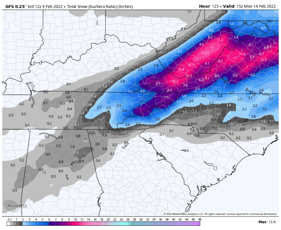
Looks like they are pretty confident in the cold air. 850 temps look to be pretty cold as well. Anyone know of what kind of ratios we would be looking at? Pretty clear the back end could have some higher ratio snows. The Kutchera maps at least confirm that it will be averaging higher than 10:1. -
March 11th-13th Winter Weather Event. Winter's last gasp?
Silas Lang replied to Windspeed's topic in Tennessee Valley
Yeah this thing has been pretty locked in for a week already. Kind of nuts. If this lands, it will be the biggest snow for the East this season. Here are MRX's thoughts: Big changes are in store for the late week and weekend as the upper pattern begins to quickly amplify in response to a northern stream shortwave from Alberta that digs south into the plains and phases with a southern stream disturbance along the four-corners. The resulting trough digs into the eastern two-thirds of the CONUS while strong surface high pressure moves into the plains and strengthens a thermal gradient from the western Gulf and across the Tennessee and Ohio Valley. Increasing upper level ascent from a dual jet structure accompanying strong advection of moisture poleward will support a quick increase in precipitation Friday evening/night and continuing into Saturday. A surface low will develop along the baroclinic zone Friday night and move into the Southern Appalachians on Saturday with increasing moisture wrapping around this circulation. At the same time, an anomalous airmass will move into the area as 850mb temperatures crash into the -10 to -15 C range. A quick transition from rain to snow will likely occur late Friday night and into Saturday. There is still a notable amount of uncertainty regarding the actual track of this system, the arrival of the cold air and just how much left over moisture will be available. What is more certain is that temperatures will be well below normal Saturday and Saturday night. Highs on Saturday will struggle to get much above freezing with expected cloud cover along with cold air advection. NBM suggests highs in the lower to mid 30`s across most locations which is already several degree cooler than NBM guidance 24 hours ago. Saturday nights lows will likely crash into the teens to lower 20`s which is 15-20 degrees below normal -
Spring/Summer 2022 Medium/Long Range Forecast Discussion.
Silas Lang replied to John1122's topic in Tennessee Valley
MRX looks like they are finally taking the system seriously. Huge Euro run last night. 6z GFS took a step back. Let's see what the 12z suite bring us today. -
Spring/Summer 2022 Medium/Long Range Forecast Discussion.
Silas Lang replied to John1122's topic in Tennessee Valley
Wow total cave by the Euro. It made a small adjustment towards the GFS last night, but now they are looking almost identical. Crazy this snow is forecast for the first day of Spring Break here. -
Spring/Summer 2022 Medium/Long Range Forecast Discussion.
Silas Lang replied to John1122's topic in Tennessee Valley
Euro looks like it has started moving toward the GFS solution last night. Not as high snow totals, but a big jump from 12z. -
Same. Just posted in the obs thread. The radar looks juiced too. Showing snow to the north west. Any obs from the Plateau? Like even if it is just rain here, the radar is showing a lot more moisture than the models did. Earlier too.
-
Started sleeting here. Pretty large sleet pellets. Don't know if I have seen any so big. Like mini hail balls. lol
- 167 replies
-
- 2
-

-
- frost
- cold front
- (and 4 more)
-
Just heard a rumble of thunder. Got 1.54 inches of rain so far today...looking at the radar, it looks a bit more robust than the even the latest NAM . Neighbor's yard ponding up already. Going to boat to work tomorrow at this point I suppose.
- 167 replies
-
- 1
-
-
- frost
- cold front
- (and 4 more)
-
Even with the GFS, the temps seem to warm pretty quickly after the snow falls. Still wouldn't mind a quick thump.
-
Heard thunder early this AM. TIMs model is showing a chance for snow!
-
Yeah, better there than north. I noticed yesterday the Euro 12z had it far north (like in Ohio) while the GFS had it crushed SE in the Atlantic. Looks like models are trending toward the middle today. Have my doubts for TYS, but I hope someone can score with this storm! Cold temps definitely seem on deck for all.
-
Me after looking at the 12z GFS

-
Same. Mountains and some upper Plateau areas can score later, but it typically ends up as a cold rain here. Not really interested in that. If it is going to rain, then I at least want it warmer.
-
I appreciate this post. And LOL at the last part. On the NOCA, yeah, not feeling too interested in winter for the foreseeable future due how things have been trending. I do like that about this forum; not a whole lot of cliff diving. We all just tend to quietly walk away. Anyway could feel the front blowing in today as it got cooler. Sitting at 40 here now.
- 167 replies
-
- 1
-
-
- frost
- cold front
- (and 4 more)
-
Fall/Winter Banter - Football, Basketball, Snowball?
Silas Lang replied to John1122's topic in Tennessee Valley
Looks like we are trending towards mostly cloudy in regards to the weekend system. Snow chances went poof on most models today. -
I will take that analogue in a heartbeat. Looks like a wide spread 2 to 4 inch event in East TN according to the thread.
-
Ah okay, that makes it easier to visualize as I feel like we have seen that set-up dozens of times the past few years here in the east. lol Do you know of any historical events that gave us snow here in the east similar to this storm?
-
Good to at least see some snow on the CMC. Thanks for the clarification. It almost looks like the CMC wants to make that low the main low and doesn't transfer until well north. I can see how this set up throws off the models. They don't know where to place the low which creates a high bust scenario. Plus you factor in all this energy flying around...yikes. I will say, I am feeling more confident we will see snow Sunday. How much remains to be seen.
-
Just curious, could that other LP you mentioned earlier on the other side of the mountains be a faint signal for an inland runner? Don't want to get greedy, but if we are getting close to a big dog event...I would like it. We do have the fact that John is going to be in Chattanooga to increase our luck
-
12z top and 6z bottom
.thumb.png.cb1aff5a8e9a9f915e807d757d5da067.png)
-
Yeah the RGEM was looking to form a low in the gulf as well. Curious to see what the Euro does.
-
12z GFS looks pretty similar to 6z.


.png.3855427ecdf0f0b692c6a0d224b23d32.png)