All Activity
- Past hour
-
No frost here on the shoreline the last 2 nights. BDRs low was 35 yesterday and 33 this morning.
-
Just stop. Lol
-
Not as long; not as deep - or will be. So it appears
-
It seems about hours 72 to 96 removes the -NAO ridging in the ensemble means... but, maintains the behavior of the flow across the eastern mid latitude continent - as though it is still there. The models are "sensing" some non-linear mechanics for -NAO, powerful enough to shape the linear ( observable wave distribution ) handling whether the block is there or not. One consequence, the Euro and CMC 00z solutions. Hopefully they are wrong. Because they're attempting the dreaded rock-bottom pattern lock in using that. Particularly the CMC .. long about 156 hrs it takes tiny meso-beta scaled S/W and uses it to carve out a 3 contoured close low and when you loop it almost seems like a spontaneous manifestation with no real input. Black hole just opens up in the perfect position to impose fantastic torture. Hyperbole aside, that's that non-linearity being exposed. But it doesn't have to be right because it's beyond 120 hours. Otherwise, move to 2nd residence and don't come back until some time deep into May
-
Got down to 28 here. Die mosquitos, die!
-
To be fair this airmass affected most of the rest of the country too.
-
Hard freezes in a warming world
-
It's fallen right back into that "targeted" cold anomaly that festered the entire winter ... enabling straw men deniers two sheets away from being as smart as flat Earthers.
-
29 low here
-
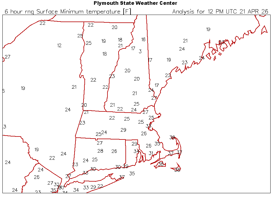
I thought the BOS record of 21° for today was a joke until I saw 16° at CON. What the hell was that airmass in 1875.
-

2026-2027 El Nino
snowman19 replied to Stormchaserchuck1's topic in Weather Forecasting and Discussion
In particular, +QBO/El Nino (regardless of strength) Decembers are a torch in the east. It’s an extremely strong signal over the last 46 years in fact….every single one of them since 1980 were torches without any exceptions. @Stormchaserchuck1 pointed that out a month ago and DT also did a write up on it several years back -
Tolland
-

Central PA Spring 2026 Discussion/Obs Thread
Superstorm replied to Voyager's topic in Upstate New York/Pennsylvania
The blocky pattern on the models continues. Needed this two months ago and it would have been a February to remember. -
-
Central PA Spring 2026 Discussion/Obs Thread
Superstorm replied to Voyager's topic in Upstate New York/Pennsylvania
They were so close to having a record high and record low within a week. That's impressive. -

Central PA Spring 2026 Discussion/Obs Thread
Mount Joy Snowman replied to Voyager's topic in Upstate New York/Pennsylvania
It looks like MDT will indeed break its daily low record of 30 by bottoming out at 29. -
Congrats everyone
-
-
Snowmaking this morning at Jay…AND camelback PA (below) I have never seen an April snowgun on in the poconos nor this late at Jay. Two mountains worlds apart going after it. .
-
10 days to go!!! And with that we will begin a 10 day countdown It's like the New Years countdown but much slower.
-

2026-2027 El Nino
LakePaste25 replied to Stormchaserchuck1's topic in Weather Forecasting and Discussion
All super ninos have featured below normal snowfall here - a 15-16 outcome vs 97-98 doesn’t make a difference for me as they both had roughly 60-80” on the season. There will always be brief cold shots on the backside of winter and sometimes even very short ones in december if we’re lucky, although december is typically the most hostile. -
6z GFS was so close day 9
- Today
-
18.3 at Churchville, 5 miles west of Staunton.
-
Even 28° for Ditty. Hopefully all of his leaves froze off.
-

Central PA Spring 2026 Discussion/Obs Thread
Blizzard of 93 replied to Voyager's topic in Upstate New York/Pennsylvania
27 in Marysville this morning.


