All Activity
- Past hour
-
#pantstent
-
Man what a day. This is what we are made for.
-
Looking like Saturday maybe not a washout and Sunday better chance for rain now?
-
Takes an extra hour to mix out there in the valley I think.
-
Re: your last statement:
-
Tomorrow looks like a bigger Ambrose Jet day than today.

-
Pretty close...
-
BDL is weird ...not just because their maxes are suspect ( if that's still the case...). Right now they're putting up a 73 .... KFIT is 83... It is 83 here... It is 80 at KASH and KBED. 73 why? I see this all the time there at this mid morning ~ time range on these warm days. Check back at 3:47 PM? 101 ... Exaggerating as a joke there but still ...their temp arc 'behavior' at that site is diurnally weird
-
Doesn't look that bad actually. Saturday morning looks fair with clouds and maybe a shwr, but no real substance till the afternoon. I just want to be able to get in our usual saturday morning cycling club ride and haven't been able to in awhile.
-
74, clouds clearing it seems
-
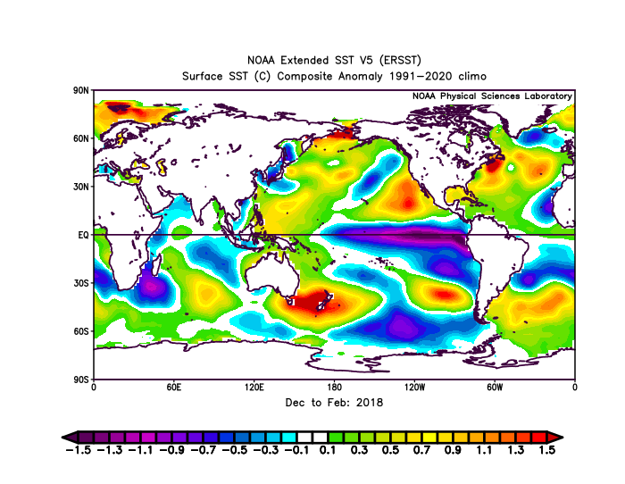
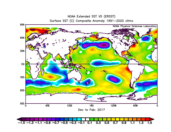
We were still +PDO through the winter of 16-17. Just look at that big cold pool south of the Aleutians and warm crescent along the West Coast. Then in 17-18 you could see the beginning of a shift with lingering warm pool near the Baja and cold pool still north of Hawaii. Still plenty of warmth up in the Bering Sea for a weaker +PDO .But this is when the first hint of warming began to the east of Japan. Thiough not to the point of being overpowering yet which began in 18-19 flipping the PDO negative and preventing the El Niño from coupling in 18-19 and 19-20.
-
Crazy how several days ago it looked like on and off rain for this weekend
-
I’m happy we had the wet May. Bank what we can before we inevitably start drying out during summer. That might be starting-models don’t have much here for the next 10 days.
-
Still sunny here. 78 already. TORCH! Drying out too which is nice...a week of no rain
-
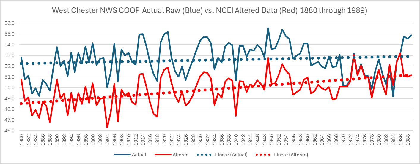
 You clearly keep making up arbitrary data. Let's dig into another station you mention above - West Chester PA. So why was West Chester also chilled by between 1.0 and 3.7 degrees each and every year for the 103 years between 1880 and 1982? Chilling the past remains the only clear man made climate changes to our data.
-
Of course it did
-
80° already and there's not much of anything for smoke. Today's going to torch.
-
Gorgeous out. However mosquitoes are brutal
-

Central PA Summer 2025
Mount Joy Snowman replied to Voyager's topic in Upstate New York/Pennsylvania
Low of 63. MDT topped out at 89 yesterday. Seems the rain chances have dropped a good bit for tomorrow but increased for sunday. -
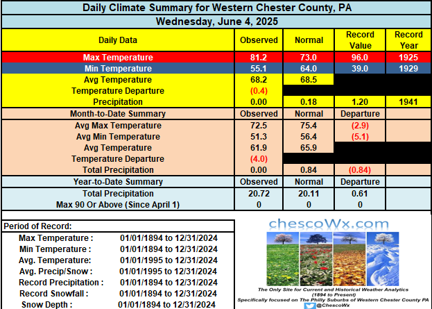
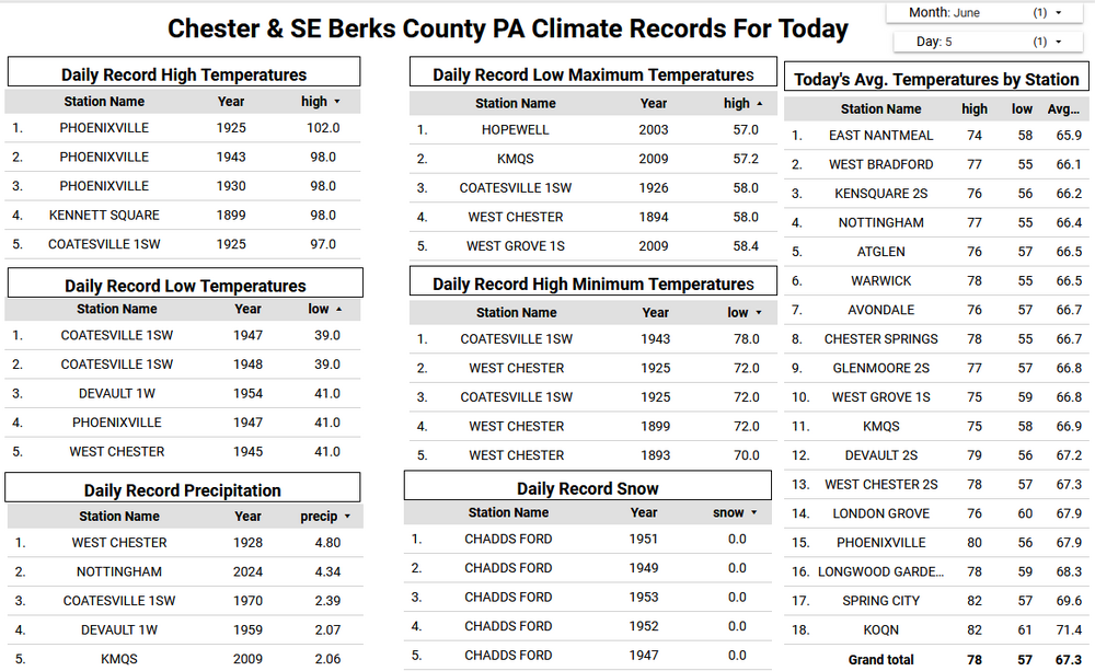
The warmest temperature across the county yesterday was, of course, at the Brandywine Airport in West Chester at 86.0 degrees. Most spots saw temperatures between 81 and 84 yesterday. Today should be a degree or two warmer and will be the warmest day for a while. The pattern turns a bit unsettled later tomorrow and through the weekend. Not a washout at all but some showers are most likely on Saturday. Shower chances appear to increase again by next Tuesday. Our relatively wet pattern looks to continue with no foreseeable heat in our future. In fact most models show near normal to slightly below average temperatures through the 4th of July.
-
E PA/NJ/DE Summer 2025 Obs/Discussion
ChescoWx replied to Hurricane Agnes's topic in Philadelphia Region
The warmest temperature across the county yesterday was, of course, at the Brandywine Airport in West Chester at 86.0 degrees. Most spots saw temperatures between 81 and 84 yesterday. Today should be a degree or two warmer and will be the warmest day for a while. The pattern turns a bit unsettled later tomorrow and through the weekend. Not a washout at all but some showers are most likely on Saturday. Shower chances appear to increase again by next Tuesday. Our relatively wet pattern looks to continue with no foreseeable heat in our future. In fact most models show near normal to slightly below average temperatures through the 4th of July.
-
Yeah from say Concord NH north it looks pretty rough for Saturday, basically a washout.
-
Records: Highs: EWR: 95 (2021) NYC: 99 (1925) LGA: 94 (2021) JFK: 90 (2010) Lows: EWR: 48 (1947) NYC: 47 (1945) LGA: 49 (1945) JFK: 50 (2023) Historical: Posted June 5, 2024 Records: Highs: EWR: 95 (2021) NYC: 99 (1925) LGA: 94 (2021) JFK: 90 (2010) Lows: EWR: 48 (1947) NYC: 47 (1945) LGA: 49 (1945) JFK: 50 (2023) Historical: 1805: A group of tornadoes tracked from southeast Missouri across the southern third of Illinois, and may also have moved into Indiana. These moved across the Mississippi River about 20 miles downstream from St. Louis, MO. Fish were reportedly "scattered all over the prairie" on the Illinois side of the river. Some pine tree tops, not native to that area of Illinois, were believed to have been blown in from at least 50 miles away. (Ref. Wilson Wx. History) 1859 - Frost was reported from Iowa to New England. The temperature dipped to 25 degrees in New York State, and up to two inches of snow blanketed Ohio. The cold and snow damaged the wheat crop. (David Ludlum) 1908 - Helena MT was deluged with 3.67 inches of rain to establish their all-time 24 hour rainfall record. (4th-5th) (The Weather Channel) 1916 - A tornado struck the town of Warren AR killing 83 persons. There were 125 deaths that day in a tornado outbreak across Missouri and Arkansas. (David Ludlum) 1917 - Residents near Topeka KS reported disk-shaped hailstones six to ten inches in diameter, and two to three inches thick. The hailstorm was accompanied by a tornado. (The Weather Channel) 1925: Earliest 100° in Washington, DC. (Ref. Washington Weather Records - KDCA) 1945: Unusually cold air moved in to parts of the upper Midwest. Chicago, IL dropped to 37° after setting a record low the previous morning with 35° while Rockford, IL dropped to 35° on both mornings. Both 35 degree readings established June record lows. (Ref. Wilson Wx. History) 1987 - International Falls, MN, dipped to a record low reading of 34 degrees during the morning. Williston, ND, and Glasgow, MT, reported record warm afternoon highs of 94 degrees. Major flooding was reported along the Guadelupe River in South Texas, with the water level at Cuero reaching 18 feet above flood stage. (The National Weather Summary) (Storm Data) 1988 - Twenty cities in the south central and eastern U.S. reported record low temperatures for the date, including Asheville NC with a reading of 40 degrees. Fifteen cities in the north central U.S. reported record high temperatures for the date. The high of 108 degrees at Glasgow MT was a record for June. (The National Weather Summary) 1989 - Thunderstorms produced severe weather from the Lower Mississippi Valley to the Southern Atlantic Coast during the day and into the night. Four tornadoes were reported, and there were 87 reports of large hail and damaging winds. (Storm Data) (The National Weather Summary) 1995: The Hurricane name was not retired in 1995 thus a different Hurricane Allison is named as the 2001 Hurricane Allison below. Hurricane Allison became the earliest hurricane on record to cross the Florida coast at when it came ashore in Taylor County at Apalachee Bay with 75 mph winds. Hurricane Allison crossed the coast near Alligator Point in the Florida Big Bend area at 0900z on the 5th. At landfall, maximum sustained winds were 69 mph with a minimum central pressure of 990 millibars. Maximum rainfall amounts were between 4 and 6 inches. Storm surge heights were estimated at 6 to 8 feet from Dixie through Wakulla counties. Total storm damage in Florida was estimated at $860,000 dollars. The 1995 Atlantic Hurricane Season went down in the record books as one of the busiest hurricane seasons since 1871. There were a total of 19 named storms, 11 of which reached hurricanes. (Ref. Wilson Wx. History) 1998: An F1 tornado touched down near the town of New Hope, MS creating a path one mile long and 50 yards wide. 13 houses had major damage and another 129 homes had minor damage. 22 mobile homes were either damaged or destroyed. Damages were estimated near $250,000 dollars. Another F1 tornado created a path two miles long and 50 yards wide 10 miles southeast of Hattiesburg, MS. 45 people were injured and two people were killed. The two fatalities were both in automobiles which ran into falling trees or the trees fell on them. (Ref. Wilson Wx. History)
-
Still around 77 degrees. After a very quick rise temps have stagnated. It's pretty cloudy right now so I'm sure that played a part.
-
77/66F, Misery underway.