All Activity
- Past hour
-
What a disaster shaping up
-

Pittsburgh PA Fall 2025 Thread
TheClimateChanger replied to TheClimateChanger's topic in Upstate New York/Pennsylvania
Certainly, a great way to break a snowfall drought with nearly 10" of snow at the airport (looks like there may have been some mixing?). -

2025-2026 ENSO
40/70 Benchmark replied to 40/70 Benchmark's topic in Weather Forecasting and Discussion
Expect the hostile trend in the polar domain to continue for later in December. -
All we need is an Arctic Front for it to hookup with and run to the Benchmark
-

2025-2026 ENSO
donsutherland1 replied to 40/70 Benchmark's topic in Weather Forecasting and Discussion
This morning revealed an unwelcome, GEFS AO forecast. If it holds, it could have implications beyond the first week of December. The base case is a generally negative AO at least to start December. But the GEFS has grown more aggressive with the AO+ scenario, with the AO reaching/exceeding +1.000 near the end of the first week in December. For now, things still remain on course for places like the Upper Midwest, Great Lakes, and central or northern New England in terms of cold an snow through at least the first 7-10 days of December. Severe cold still appears unlikely. The question afterward concerns whether the pattern will break down near mid-month or late December. The AO+ development would argue for a faster breakdown. I will need to see more data on this, but the risk of a faster breakdown has increased further since yesterday. Let's see where the GEFS and EPS are in a few days. After all, it is November 24 and model skill is weak beyond 10-14 days. What about the SSW? As @40/70 Benchmark@bluewave@snowman19 have noted on numerous occasions, it is likely to be a reflection event. The late November cold shot and first week of December developments likely have no connection to the SSW. Whether there would be the development/redevelopment or reinforcement of blocking was the wild card. Considering the nature of this event, it increasingly appears that non-stratospheric factors will play the predominant role.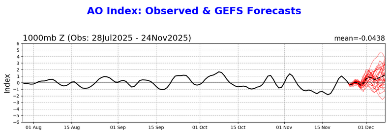
-
2025-2026 ENSO
40/70 Benchmark replied to 40/70 Benchmark's topic in Weather Forecasting and Discussion
I would expect about a mean of those 3 seasons...maybe add in 2005. -
Interesting that ILN doesn't mention weekend snow chances at all in the afd, obviously looks unlikely, but not out of the question as the 6z euro and eps show. About 1/2 members of the 0z eps had some sort of snowfall saturday into sunday, I think with this complex of a pattern you can't rule it out.
-
You are in a way better spot than I am.
-

Fall 2025 Medium/Long Range Discussion
Jackstraw replied to Chicago Storm's topic in Lakes/Ohio Valley
I know I am lol. Havent seen a fantasy run like that for my area in a loooong time for late Nov/early Dec -
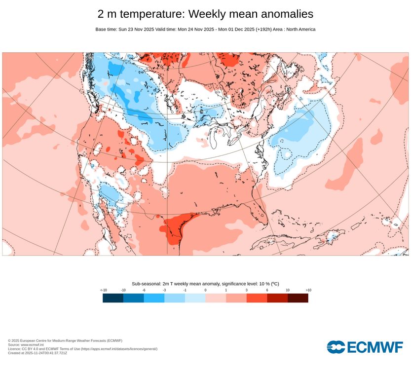
The color shift at -8 and not +8 which draws the attention to the colder anomalies. Color scales need to be balanced which most sites follow. Hopefully, it was just an inadvertent error when the color scheme was designed.
-

Central PA Fall Discussions and Obs
Itstrainingtime replied to ChescoWx's topic in Upstate New York/Pennsylvania
I have an exceptionally busy week and might not be on as much as I'd like. Before I miss my opportunity...Happy Thanksgiving to all of you. 2025 has been a rough year in a lot of ways for myself personally as well as our family. That said, so much to be thankful for. Enjoy the holiday with your families. It is a a pleasure to come here and share common interests together and have fun doing so. -
You should let the people at Pivotal Weather know about honest color schemes. Temperatures in the 60s there look like a heatwave.
-
a full cancel/grief/uncancel cycle before Thanksgiving. Yall have been practicing! This place is in late season form!
-

2025-2026 ENSO
michsnowfreak replied to 40/70 Benchmark's topic in Weather Forecasting and Discussion
Nearly all of that 2000 snow fell on December 30 though. For the record @MJO812 im certainly not saying it doesn't snow in NYC in nina decembers. Just that it's snowier than normal further north. NYC can often be on a gradient line. Plus add in the fact that those northern places already average more to begin with, and you can come up with quite a contrast by months end. -

November 2025 general discussions and probable topic derailings ...
kdxken replied to Typhoon Tip's topic in New England
I'll take it. Absolute beauty today. 44° and no clouds. Wouldn't be surprised to see 50°.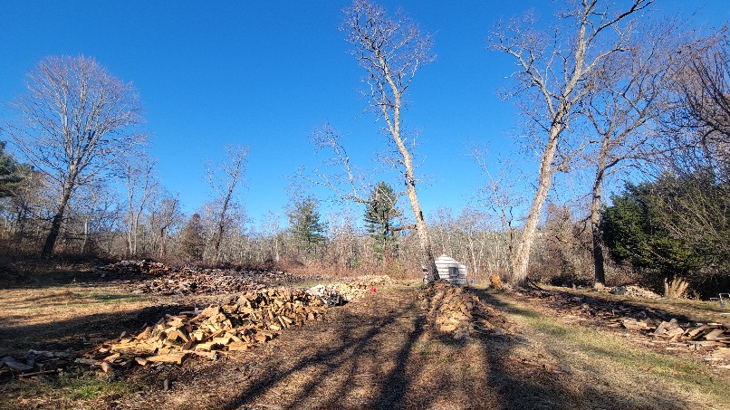
-
Looks a little above average but noting too extreme like I pointed out in my original post.
-
stayed in the mid 20's here that day-had to move the annual high school game up a day which was a bummer.
-
 There's always Valdez Alaska
 -
I didn't say anything about a torch. Just asked a question as bluewave's map of the Euro weekly showed +1 to +3C across the East this week (11/24 to 12/1).
-
Came in here for this. Haven't been following each run and assume it hasn't been consistent, but interesting and not crazy evolution as depicted. Cross-polar flow immediately before, southern stream system (from the trop pacific?!) transversing the lower 48 and with mb digging behind?
-
I remember the 2018 Thanksgiving cold snap, that was some serious mid winter style cold
-
We haven’t had any real cold around Thanksgiving since 2018. Data for November 22, 2018 through November 23, 2018 Click column heading to sort ascending, click again to sort descending. NY PORT JERVIS COOP 4 CT DANBURY MUNICIPAL AP WBAN 6 CT OXFORD WATERBURY WBAN 6 NY WESTHAMPTON GABRESKI AP WBAN 6 NJ CHARLOTTEBURG RESERVOIR COOP 7 NY SHRUB OAK COOP 7 NY MONTGOMERY ORANGE COUNTY AP WBAN 7 NY CARMEL 4N COOP 7 CT DANBURY COOP 9 CT MOUNT CARMEL COOP 9 CT MERIDEN MARKHAM MUNICIPAL AP WBAN 10 NY WEST POINT COOP 11 NJ CALDWELL ESSEX COUNTY AP WBAN 11 NY WESTCHESTER CO AP WBAN 11 CT STAMFORD 5 N COOP 12 NY SHIRLEY BROOKHAVEN AIRPORT WBAN 12 CT GROTON NEW LONDON AP WBAN 12 NJ NEWARK LIBERTY INTL AP WBAN 13 NJ CANOE BROOK COOP 13 NJ HARRISON COOP 13 CT IGOR I SIKORSKY MEMORIAL AIRPORT WBAN 13 CT NEW HAVEN TWEED AP WBAN 13 NY UPTON COOP - NWSFO NEW YORK COOP 13 CT GROTON COOP 13 CT NORWICH PUBLIC UTILITY PLANT COOP 13 NY FARMINGDALE REPUBLIC AP WBAN 14 NJ TETERBORO AIRPORT WBAN 14 NY MATTITUCK COOP 14 NY JFK INTERNATIONAL AIRPORT WBAN 15 NY NY CITY CENTRAL PARK WBAN 15 NY CENTERPORT COOP 15 NY ISLIP-LI MACARTHUR AP WBAN 15 NY BRIDGEHAMPTON COOP 15 NY ORIENT POINT STATE PARK COOP 15 Data for November 22, 2018 through November 23, 2018 Click column heading to sort ascending, click again to sort descending. PA POCONO MOUNTAINS MUNICIPAL AIRPORT WBAN -2 NJ SUSSEX 1 NW COOP 5 NJ SUSSEX AIRPORT WBAN 6 PA SPRINGTOWN 1 NNE COOP 7 PA EAST STROUDSBURG COOP 7 PA BELTZVILLE DAM COOP 8 PA LEHIGHTON 1SSW COOP 8 NJ BELVIDERE BRIDGE COOP 8 NJ AEROFLEX-ANDOVER AIRPORT WBAN 8 NJ HIGHTSTOWN 2 W COOP 9 NJ WERTSVILLE 4 NE COOP 9 NJ SOMERSET AIRPORT WBAN 9 NJ NEW BRUNSWICK 3 SE COOP 9 PA BLUE MARSH LAKE COOP 10 PA GRATERFORD 1 E COOP 10 PA SELLERSVILLE COOP 10 PA BUCKSVILLE COOP 10 NJ FLEMINGTON 5 NNW COOP 10 NJ FREEHOLD-MARLBORO COOP 10 NJ BOONTON 1 SE COOP 10
-
Whats wrong with it
-
Models also had mild weather for this time. Thats why its hard to take the long range seriously.
-
Good in December 2000, bad in 2007 and good in 2008.


.thumb.jpg.ad3a2e31d30aff035044689b311a0540.jpg)


