All Activity
- Past hour
-

The “I bring the mojo” Jan 30-Feb 1 potential winter storm
Met1985 replied to lilj4425's topic in Southeastern States
You shouldn't be surprised. -
Excellent trends on the 06z NAM. The upper levels show digging into the Missouri bootheel and NE Arkansas at 75 where it was east of the Mississippi at 0z. 84 land shows the beginnings of a lee side low behind the main one which is 250 miles ENE off the space coast (lol). RGEM holds serve mostly. It's been a minute since looking but the surface pressure gradient seemed slightly less positive tilt and overall org a bit smudgier. Cold might be a little punchier if the 500mb level translates.
-

The Jan 31 Potential: Stormtracker Failure or 'Tracker Trouncing
wdcrob replied to stormtracker's topic in Mid Atlantic
-

The “I bring the mojo” Jan 30-Feb 1 potential winter storm
lilj4425 replied to lilj4425's topic in Southeastern States
That southern line of the cutoff continues to move north though. -

The “I bring the mojo” Jan 30-Feb 1 potential winter storm
BornAgain13 replied to lilj4425's topic in Southeastern States
RRFS A , still snowing at the end of this..thumb.png.f5119c59c0b197e8ece38a7c10aa60b7.png)
-

The Jan 31 Potential: Stormtracker Failure or 'Tracker Trouncing
Terpeast replied to stormtracker's topic in Mid Atlantic
Seeing all that snow just next door south of us makes me think we're definitely still in the game. Like PSU said, we just want that to trend north at game time. If that snow was to the east of us instead of south, this thing is DOA. -
If 06z Euro brings it NW, you're going to see the mother of all Bi-Polar mood swings on here.
-

The Jan 31 Potential: Stormtracker Failure or 'Tracker Trouncing
snowfan replied to stormtracker's topic in Mid Atlantic
BTW, 0Z euro kept most at or below freezing until Feb 7. -
 Seeing that snowhole from DC to NYC while VA and NC get a blizzard is heartbreaking though. Thats how we roll here.
 -

The “I bring the mojo” Jan 30-Feb 1 potential winter storm
NorthHillsWx replied to lilj4425's topic in Southeastern States
Pretty dang consistent all things considered -
GFS folded. Shocker. I think its time to put this one to bed for areas along I-95. Sorry.
-

Central PA Winter 25/26 Discussion and Obs
pawatch replied to MAG5035's topic in Upstate New York/Pennsylvania
-6 degrees…yep it’s cold. One thing about this snow, my yard looks just as good as my neighbors yard. -
The “I bring the mojo” Jan 30-Feb 1 potential winter storm
BornAgain13 replied to lilj4425's topic in Southeastern States
Very true. I need sleep lol -
The “I bring the mojo” Jan 30-Feb 1 potential winter storm
BornAgain13 replied to lilj4425's topic in Southeastern States
5 run trend of GFS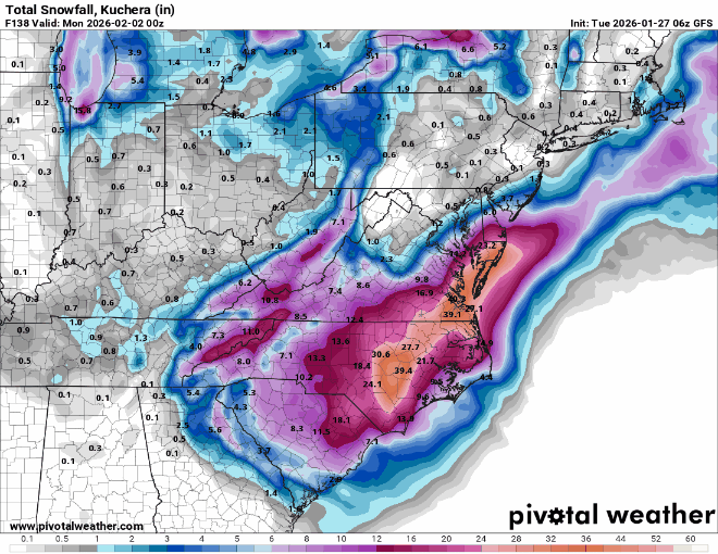
-
The “I bring the mojo” Jan 30-Feb 1 potential winter storm
NorthHillsWx replied to lilj4425's topic in Southeastern States
Not many times we get to argue over 15-30” vs 35-40” clown maps within 3 days of a storm -

1-30/2-1-26 Arctic Blast, ULL Snow Event
fountainguy97 replied to John1122's topic in Tennessee Valley
Models are in pretty good agreement with regards to the ULL energy diving a precip maxima from ETN down into SC/NC. The main question continues to be the coastal. ON euro/gfs/nam our starting ratios are 15:1 and peak at 24:1 toward the end of the event. It won't take much qpf at all. .5 qpf at 15:1 is 7.5"- 13 replies
-
- 1
-

-
- extreme cold
- snow
- (and 1 more)
-
Unlikely for this to offer a good surprise for the forum, but I'd wait to see if the energy from the kicker winds up more strung out and further WNW. Very curious to see the 500mb depictions at 12z and 00z. Im not buying the low closing off down in Georgia. Regardless, fun one to track.
-

The Jan 31 Potential: Stormtracker Failure or 'Tracker Trouncing
Weather Will replied to stormtracker's topic in Mid Atlantic
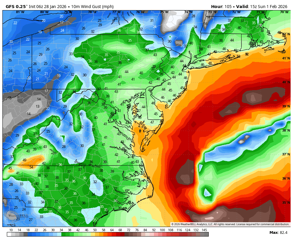
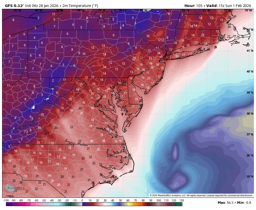
WB 6Z GFS says Sunday will at least be windy and frigid.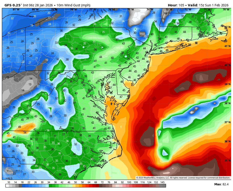

-
Weather Next 00z has the .25-.50 line back to my area with .50 creeping into NE Tn. The 18z crapped out and never finished. That is a big improvement west over 12z yesterday, which barely had the .25-.50 in far NE Tn.
-

Possible coastal storm centered on Feb 1 2026.
ineedsnow replied to Typhoon Tip's topic in New England
GFS OTS but what is that piece of energy coming in from Quebec.. its looks like it originated from the North Atlantic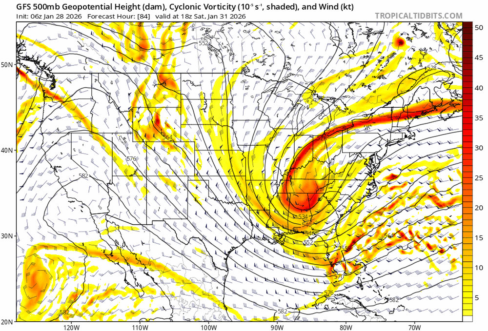
-

E PA/NJ/DE Winter 2025-26 Obs/Discussion
MickeyTim6533 replied to LVblizzard's topic in Philadelphia Region
agree, not off to a good start. there's literally nothing pointing to this making the turn northwest. -

Winter 2025-26 Short Range Discussion
KeenerWx replied to SchaumburgStormer's topic in Lakes/Ohio Valley
Rather localized and uncertain on extent of impact. Potential exists, but I’m not seeing a bonafide signal for robust stationary S/SW lake response. We shall see as it becomes more immediate. Much less enthusiastic about inland push of significance than LOT seems to be. But I’m not a met for good reason -
The AI GFS QPF totals, .14 in Nashville, with generally 17:1 to 20:1 ratios. .20 the next tier of counties eastward, trailing SE towards Chattanooga. Around .30 in Cookeville to McMinn Co. .40 in counties along the 75 corridor from my area down to Knoxville. .5 around Morristown. .5 to .7 along the NC border areas into SW VA. The DGZ in nearly to the surface with -12c being around 2400 feet and high humidity from there to 700mb.
-
Well it was fun tracking but this one is done.
-

E PA/NJ/DE Winter 2025-26 Obs/Discussion
Duca892 replied to LVblizzard's topic in Philadelphia Region
Yeaaaaa this one ain’t for us. You would need the mother load of drastic shifts to occur almost every single run with 0 steps backward from here on out after another GFS whiff. Lots of winter to go


.png.f9f9058e3db38721b79cf390f0e4ec98.png)