All Activity
- Past hour
-
Yep. The only exception I can think of is one of those late season stalled fronts where it’s shorts weather to the south and waves of snow a couple hundred miles north. It isn’t the right time of year for that. It’s late Feb through early April for that kind of setup. Mid-winter big dogs need that arctic air nearby, usually to the NW.
-

December 2025 regional war/obs/disco thread
SnowGoose69 replied to Torch Tiger's topic in New England
As long as Canada stays cold this flips quickly if the PNA goes positive if the other indices largely remain where they are. If somehow though we get a week or 2 of a GOA vortex we're probably done til 1/20 at least. No signs of that though -
Those Euro weeklies are horrendously warm!
-

December 2025 regional war/obs/disco thread
40/70 Benchmark replied to Torch Tiger's topic in New England
Pattern update. https://easternmassweather.blogspot.com/2025/12/mid-month-warm-up-arrives-on-schedule.html -

December 2025 Short/Medium Range Forecast Thread
Golf757075 replied to John1122's topic in Tennessee Valley
I think a true pattern change will take place when the mjo starts to move. Takes a while to get out of warm patterns if they become established imo -
It will be quite the spectacle to see what wins out. The raging Pacific or growing -AO/-NAO
-
Winter 2025-2026 Offers Return to Normalcy
40/70 Benchmark replied to 40/70 Benchmark's topic in New England
Mid-Month Warm Up Arrives On Schedule Path to White Christmas Remains Despite Friday Grinch December Forecast Largely On Track Thus far the month of December has behaved largely as expected, primarily owed to the similarity of the anticipated deviation from the predominate Maritime Continent forcing of the past decade, to the analog periods of December-January 2017-2018 and 2024-2025. December 1-13 2025: December 2017-January 2018: December 2024-January 2025: The primary differences being that this month has been more extreme in terms of the magnitude of negative temperature departures, possibly owed to the extreme Bering Sea blocking (-WPO) that has been observed (-3.48 WPO peak on 12/13). The polar vortex disruption that occurred late last month has behaved remarkably similar to the early December 2000 analog event in that it fell just shy of triggering a full 850MB zonal mean wind reversal in the arctic. This has afforded the vortex the opportunity to recover to something that will approach climo levels by the holiday week, as forecast last fall per research conducted Lee et al (2019), which indicates that the arctic high regime is favored for less than 20 days following a weak PV (roughly November 28th). This despite the insistence of initial modeling and social mediaologoists alike that it would remain weak through the new year. This consistent recovery following the lack of a zonal wind reversal has allowed the high latitude blocking to relinquish it's grip by mid-month, as forecast. The increasingly hostile polar domain in conjunction with lowering heights on the west coast as reflected by a descending PNA value will allow the storm track to shift west just in time for the expected "Grinch Storm" this Friday, which will eradicate all of the snowpack throughout southern New England. This is event is similar to periods prior to the Christmas holiday in the referenced analog months of December 2007 and 2008, especially the former. Thereafter, there is going to be a battle waged throughout the holiday period as the MJO remains shallow and variable, while the Pacific Trough regime begins to assert itself. White Christmas Odds Perilous As Pacific Trough Regime Establishes One of the primary assertions made in the Eastern Mass Winter Outlook last fall was that the aforementioned recovery of the polar vortex and persistent RNA pattern would team up to induce a Pacific trough pattern during the second half of the month, as a potential pre-cursor to a January stratospheric reflection event. Current long range guidance now reflects such a pattern. While the forecast for the balance of 2025 would appear rather unchallenging, things are seldom as they appear in weather. In this particular instance, the caveat is an MJO wave that is expected to remain rather meager and variable after having largely dissipated over the course of the past week following its brief flirtation with phase 8 near the outset of the month. This disjointed signal will allow an occasional element of west Pacific expression to assert itself into the pattern as a byproduct of areas of dual forcing, especially into the final weak of the month, which will allow for some potential colder intrusions into the northeastern quarter of the country. Christmas Eve 500mb depiction per EURO Weekly product, EURO ensemble package, GFS ensemble and Canadian ENSEMBLE. Having a supply of cold near by means that the likelihood of a white Christmas across the southern New England forecast area, while unlikely after the visit from the Grinch on Friday, can not be discounted since there may be some weak northern stream energy passing through in the vicinity of the holiday. There is also some suggestion amongst guidance that Scandinavian blocking could develop by the New Year, which could represent a precursor to an episode of some Greenland Blocking prior to the development of any subsequent refection event later in January. Although the pattern is unquestionably turning milder on average, it would be advisable to stay tuned for updates as the all important holiday period approaches because the devil is often in the details. -
Beer?
-

December 2025 Short/Medium Range Forecast Thread
Carvers Gap replied to John1122's topic in Tennessee Valley
Yeah, cold and viruses have been making laps in my crew. Pretty miserable stuff and hangs on forever as @Daniel Boonenoted. Hopefully the 12z Euro Weeklies are right and we see cold return right after mid-January. The 12z CFSv2 breaks for cold at about the same time. It looks like when the NAO fires(if it fires), that puts a clock on the chinook. Maybe if that NAO can fire earlier, we can return to a colder pattern more quickly. But really, I am good with a couple of weeks of warm weather. Something makes me think the dam is gonna bust at some point sooner than later. One good cutter, and it could all come south. -

Winter 2025-26 Medium/Long Range Discussion
A-L-E-K replied to michsnowfreak's topic in Lakes/Ohio Valley
unrelenting pac jet ftw there -
.
-

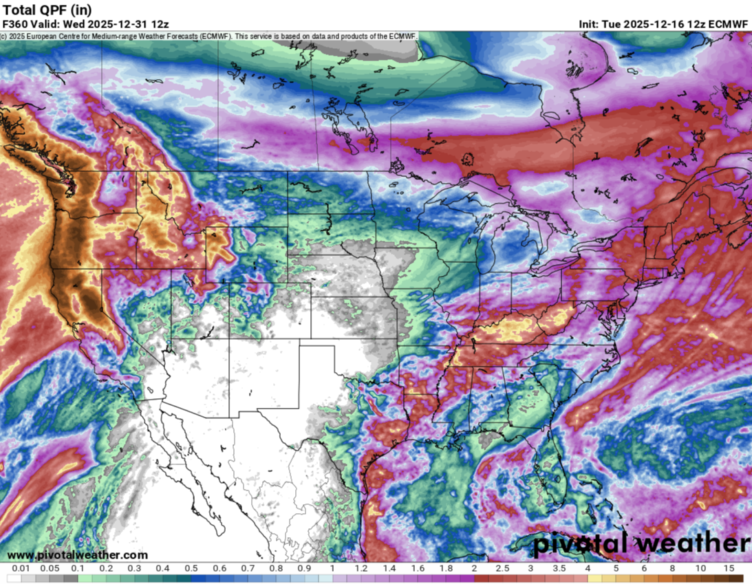
Winter 2025-26 Medium/Long Range Discussion
TheClimateChanger replied to michsnowfreak's topic in Lakes/Ohio Valley
Wow, that's a lot of rain on top of the ongoing flooding in the Pacific Northwest. -

December 2025 regional war/obs/disco thread
WxWatcher007 replied to Torch Tiger's topic in New England
Sometimes the writing is on the wall (last year), but we’re in a different position this year. We have to get lucky, but we’re at least in the game for something next week. Like Steve said, we’re wired to want a white Christmas. We could be in the Midwest with absolutely no hope. -
the human body acclimates remarkably quickly.
-

Winter 2025-26 Medium/Long Range Discussion
Malacka11 replied to michsnowfreak's topic in Lakes/Ohio Valley
Abused By The Weather: A Report on Trauma Responses and Grief Processing Stage Indicators Based on Online Hobby Weather Forums -
while i grow to hate cad more each passing year, you really do need deep cold nearby for the big dogs that really crank
-
Won't they have to get the Bob houses off before the rain? Most of the ice will be gone.
-
The refrigerant under the ice will be fine no matter the ambient air temp.
-
Natural gas is down still another 3% today making it a total of a whopping 29% just since the high of Dec 4th!
-

December 2025 regional war/obs/disco thread
Ginx snewx replied to Torch Tiger's topic in New England
The white Christmas theme is baked into us. But really is there any scene more beautiful than Christmas Lights with fresh fallen snow Those of us old old weenies know winter just began in SNE this week. So much time left. The Patriots fans declaring victory up 21 to 0 are our winter over peeps..jpeg.5bf642ab5bb7e4c2fb5f387d4d3cce14.jpeg)
-
After a low of 13.5, temp is 41 which feels very comfortable compared to yesterday.
-
Winter 2025-26 Medium/Long Range Discussion
A-L-E-K replied to michsnowfreak's topic in Lakes/Ohio Valley
we deserve better
-
Yep. Not panicking yet, but if we haven’t moved that Aleutian Ridge by week 2 in Jan, I’ll get really bearish.
-
I just hope we start seeing legit signs of something better in January before January turns into February
-
Selfishly, I spend most of my time here and would love to get our former forum stalwarts back to posting on AmericanWx. We’ve segmented more the last few years by region since many have dropped off and I think that’s only enhanced discussions.