All Activity
- Past hour
-
How about pee pee?
-
 cheapest viagra: Belvion - sildenafil online
 -
Looks a lot like it save for the deep se/FL.
-
We have a shot at 3 months in a row where part of the region goes 10”+. Monthly Data for September 2026 for Upton NY NWS CWA Click column heading to sort ascending, click again to sort descending. CT NORTHFORD 0.8 SW CoCoRaHS 8.22 CT FAIRFIELD 1.5 NE CoCoRaHS 7.97 CT DARIEN 2.4 NW CoCoRaHS 7.64 CT NORWALK 1.4 ENE CoCoRaHS 7.36 CT TRUMBULL 2.6 SSE CoCoRaHS 7.14 CT STAMFORD 1.0 S CoCoRaHS 6.69 CT JEWETT CITY 3.0 ESE CoCoRaHS 6.68 NJ FAIR LAWN 1.2 SE CoCoRaHS 6.63 CT NORWALK 2.9 NNW CoCoRaHS 6.55 Monthly Data for August 2026 for Upton NY NWS CWA Click column heading to sort ascending, click again to sort descending. NJ CLARK TWP 1.3 ENE CoCoRaHS 12.48 NJ LINDEN 2.2 NW CoCoRaHS 12.19 NJ HARRISON COOP 11.78 NJ CRANFORD TWP 1.1 ESE CoCoRaHS 10.99 NY FRANKLIN SQUARE 1.1 N CoCoRaHS 10.92 NJ CLARK TWP 0.7 SSW CoCoRaHS 10.88 NJ KEARNY 1.7 NNW CoCoRaHS 10.88 NJ NEWARK LIBERTY INTL AP WBAN 10.19 Monthly Data for July 2026 for Upton NY NWS CWA Click column heading to sort ascending, click again to sort descending. NY BEACON 4.2 ESE CoCoRaHS 17.14 NY PEEKSKILL 2.8 NNE CoCoRaHS 16.45 CT BETHEL 0.5 E CoCoRaHS 15.83 CT DANBURY COOP 15.12 NY NELSONVILLE 0.3 S CoCoRaHS 14.54 CT NEWTOWN 5.3 S CoCoRaHS 14.51 CT BETHEL 3.5 NNE CoCoRaHS 14.07 CT OAKDALE 2.6 WNW CoCoRaHS 13.97 NY SHRUB OAK COOP 13.93 NY GARRISON 1.5 NE CoCoRaHS 13.76 CT NEWTOWN 4.6 SE CoCoRaHS 13.64 CT SALEM 3.6 SE CoCoRaHS 13.60 CT STRATFORD 0.2 ESE CoCoRaHS 13.43 CT SHELTON 1.3 W CoCoRaHS 13.23 CT SHELTON 1.3 W CoCoRaHS 13.12 CT NORTHFORD 0.8 SW CoCoRaHS 13.11 CT BETHEL 4.5 SSE CoCoRaHS 13.09 CT FAIRFIELD 1.5 NE CoCoRaHS 13.08 CT CHESTER CENTER 2.7 WNW CoCoRaHS 12.93 NY YORKTOWN HEIGHTS 2.7 NNW CoCoRaHS 12.43 CT TRUMBULL 2.6 SSE CoCoRaHS 12.43 CT BROOKFIELD 3.3 SSE CoCoRaHS 12.42 CT IGOR I SIKORSKY MEMORIAL AIRPORT WBAN 12.33 NY CARMEL 4N COOP 11.95 CT RIDGEFIELD 2.4 NNE CoCoRaHS 11.84 NY SEAFORD 0.4 SE CoCoRaHS 11.82 NY LAKE CARMEL 0.7 NE CoCoRaHS 11.75 NJ HAWTHORNE 1.0 SSE CoCoRaHS 11.71 CT SOUTHBURY 2.3 W CoCoRaHS 11.53 NY PATTERSON 1.3 E CoCoRaHS 11.28 CT GUILFORD COOP 11.19 NY NEW WINDSOR 3.3 W CoCoRaHS 11.18 NJ CEDAR GROVE TWP 0.4 W CoCoRaHS 11.17 CT DURHAM 1.2 W CoCoRaHS 11.14 CT WALLINGFORD CENTER 1.9 WNW CoCoRaHS 11.13 CT NEW CANAAN 1.9 ENE CoCoRaHS 11.06 CT LEDYARD 0.5 NE CoCoRaHS 11.04 CT WALLINGFORD CENTER 3.3 NNW CoCoRaHS 11.03 CT MIDDLEFIELD 1.4 W CoCoRaHS 10.97 CT MIDDLEFIELD 0.6 SE CoCoRaHS 10.96 CT RIDGEFIELD 3.6 N CoCoRaHS 10.92 NY CENTEREACH 1.3 NE CoCoRaHS 10.88 CT NORWALK 2.9 NNW CoCoRaHS 10.83 CT ANSONIA 1 NW COOP 10.78 NY STONY POINT 0.7 NW CoCoRaHS 10.73 CT STRATFORD 0.9 W CoCoRaHS 10.69 CT CROMWELL 0.4 WNW CoCoRaHS 10.62 CT WALLINGFORD CENTER 1.1 N CoCoRaHS 10.55 NJ RIVER EDGE 0.4 NNE CoCoRaHS 10.32 CT PROSPECT 1.9 ENE CoCoRaHS 10.31 NY PORT JERVIS COOP 10.30 CT LEDYARD 2.8 NNE CoCoRaHS 10.25 NJ MONTCLAIR 0.7 N CoCoRaHS 10.22 NJ FAIR LAWN 0.9 E CoCoRaHS 10.22 NY MOUNT SINAI COOP 10.21 CT NORWICH 5.4 SE CoCoRaHS 10.17 NJ WAYNE TWP 2.3 ESE CoCoRaHS 10.13 CT SHERMAN 1.2 E CoCoRaHS 10.13 CT HIGGANUM 0.7 N CoCoRaHS 10.13 CT HIGGANUM 0.8 NE CoCoRaHS 10.05 CT NORWICH 5.2 SE CoCoRaHS 10.04 CT WALLINGFORD 3.1 N CoCoRaHS 10.03
-
(002).thumb.png.6e3d9d46bca5fe41aab7a74871dd8af8.png)
Central PA Summer 2026 Discussion/Obs Thread
ChescoWx replied to Voyager's topic in Upstate New York/Pennsylvania
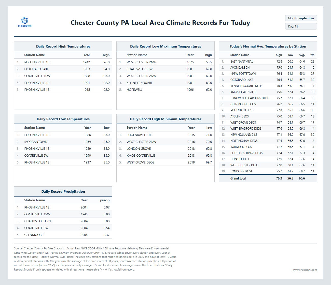
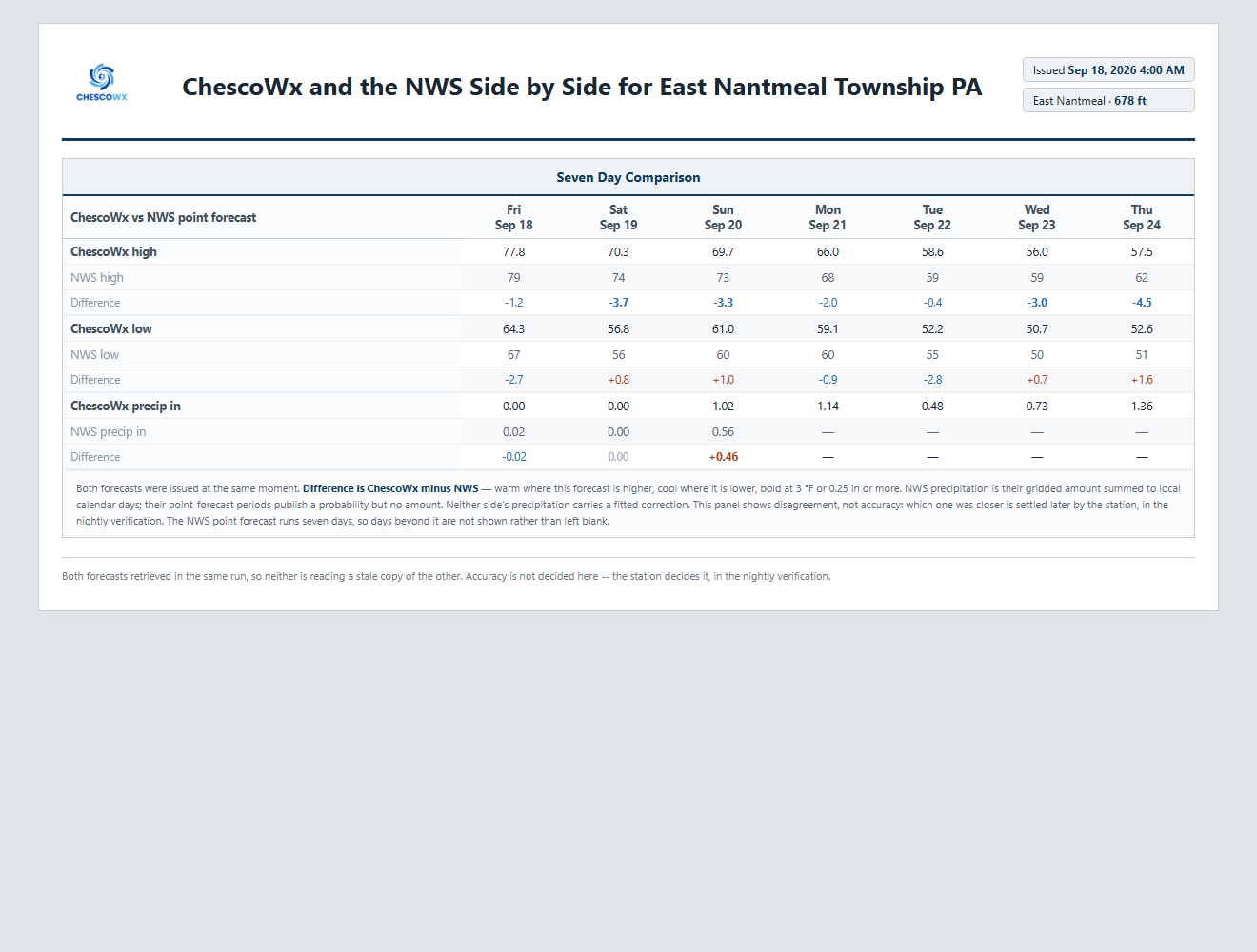
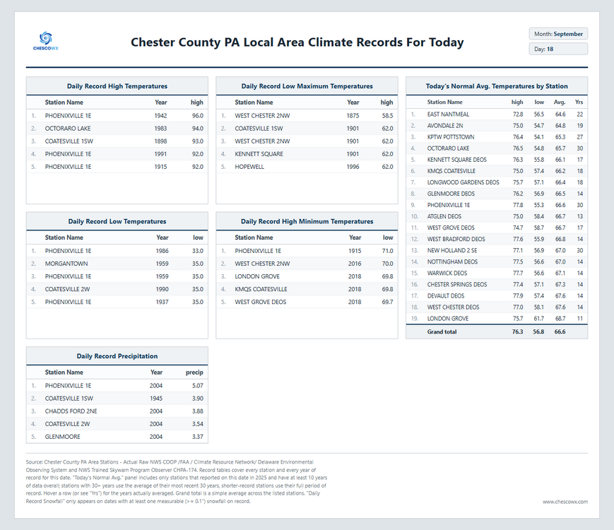
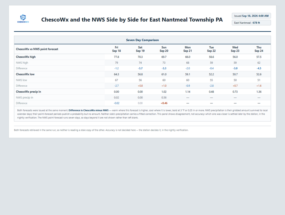
Today will be the last day for over a week with above normal temperatures in the upper 70's to near 80 degrees. We fall off to the upper 60's to low 70's tomorrow and with near record setting low maximum temperatures possible both Tuesday and Wednesday. High temperatures both of those days will struggle into the mid to upper 50's. Those temperatures are typical for November 10th! In addition to the unseasonable chill this week it will also be very wet. Rain chances increase by Sunday, and chances remain each and every day of the new work week. The in-house ChescoWx model predicts over 4 inches of rain this week!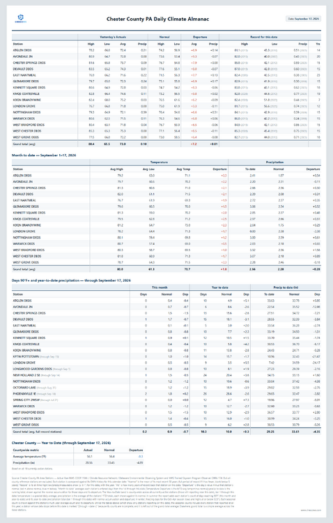
-
E PA/NJ/DE Autumn 2026 Obs/Discussion
ChescoWx replied to PhiEaglesfan712's topic in Philadelphia Region
Today will be the last day for over a week with above normal temperatures in the upper 70's to near 80 degrees. We fall off to the upper 60's to low 70's tomorrow and with near record setting low maximum temperatures possible both Tuesday and Wednesday. High temperatures both of those days will struggle into the mid to upper 50's. Those temperatures are typical for November 10th! In addition to the unseasonable chill this week it will also be very wet. Rain chances increase by Sunday, and chances remain each and every day of the new work week. The in-house ChescoWx model predicts over 4 inches of rain this week!
-

E PA/NJ/DE Autumn 2026 Obs/Discussion
The Iceman replied to PhiEaglesfan712's topic in Philadelphia Region
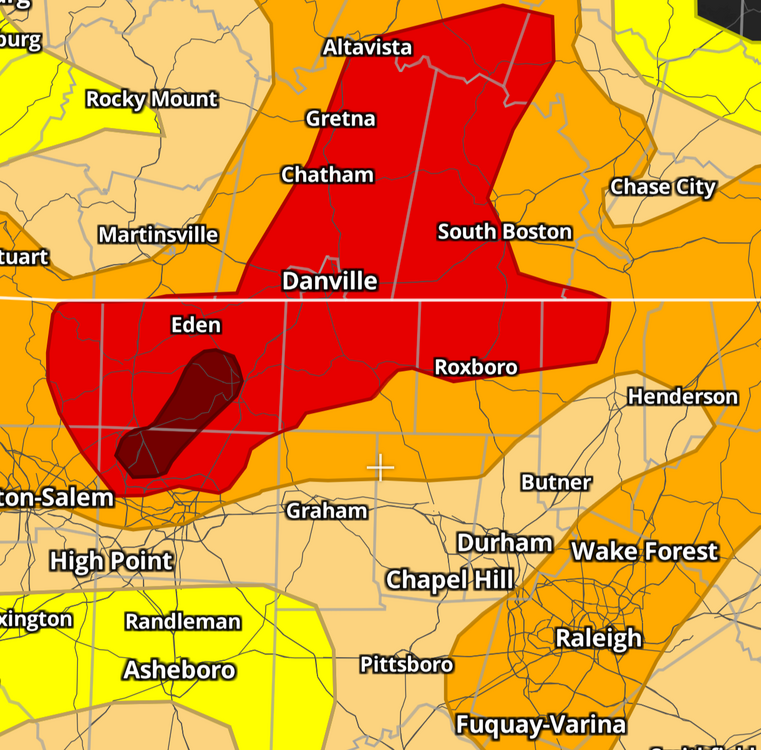
Next week looking wet... I don't have my official total nearby for the month but I believe we are already at 5" or so. Could we get back to back months of double digit(10"+) rainfall? The drought has been beaten back big time this summer, crazy this was the drought map just 3 months ago! to now: -
Drought outlook update
-
Cialis over the counter: menon36 - Tadalafil price
-
Classic ridge on top onshore flow and trough cutoffs underneath into the northeast 9/21 - 9/26
-
Two rain events last weekend, but only 0.8" total. Also our monthly total. Drought conditions also declined- from D1 to D2.
-
ecords: Highs: EWR: 90 (1992) NYC: 91 (1891) LGA: 89 (1965) JFK: 90 (1965) Lows: EWR: 42 (1937) NYC: 44 (1990) LGA: 49 (1990) JFK: 46 (1961) Historical: 1752: The hurricane of 1752 was one of the most devastating in the history of Charleston, SC. Although the number of fatalities could not be determined, a contemporary Boston press report, based on a ship officer's account, estimated that 95 people drowned. The destruction of trees was severe. One plantation owner's loss was assessed at $50,000. (Ref. AccWeather Weather History) 1816: A tropical storm affected Virginia before moving northeast into New York. Heavy rains caused the James river in Richmond to rise only an inch or two lower than the High Fresh of 1814. Flood waters invaded the first floors of area homes. One bridge was submerged, cutting off travel (Chapman). (Ref. for Tropical Storm of 1816) 1886: A tornado moved along the Des Plaines River in northeast Illinois, hitting the city of Joliet. The tornado destroyed 20 homes, 10 barns, two factories, and a grain elevator; a bridge was moved intact for two blocks. 20 people were injured, but the loud roar of the approaching tornado allowed residents time to take shelter, so no one was killed. (Ref. Wilson Wx. History) 1926 - The great ""Miami Hurricane"" produced winds reaching 138 mph which drove ocean waters into the Biscayne Bay drowning 135 persons. The eye of the hurricane passed over Miami, at which time the barometric pressure reached 27.61 inches. Tides up to twelve feet high accompanied the hurricane, which claimed a total of 372 lives. (David Ludlum) (The Weather Channel) 1933: The September 17th and 18th storm gave 13.27 inches of rain at Provincetown, MA causing severe flooding! (Ref. Notable New England Hurricanes) 1936: A passing hurricane did heavy damage in Salisbury Maryland and gave 4.61 inches of rain in Washington, DC and Baltimore received only a trace of rain. 1936 Hurricane Track - Weather Underground 1941: A remarkable aurora borealis or "northern lights" was observed as far south as north Florida on this night and the 19th. (Ref. Wilson Wx. History) 1971: A brush fire at Lake Alexander, MN in Morrison County started a 10-foot wide, 50-foot high "fire whirl." It moved out over the lake, overturned a 1,800 pound pontoon boat, and then dissipated as it moved back to shore. (Ref. AccWeather Weather History) 1950: Hail covered the ground to a depth of 2 inches at Phoenix, AZ. Damage was extensive at the airport, where 22 planes were destroyed. (Ref. Wilson Wx. History) 1978: Parts of the northern Rockies received some early season snow. 21 inches of snow fell at Red Lodge, MT reported 21 inches. Lesser amounts fell at lower elevations. Joliet, MT received 1.5 inches and Billings, MT received a trace. (Ref. Wilson Wx. History) 1987 - Early morning thunderstorms in northern Texas produced wind gusts to 65 mph at Sulphur Springs, and 2.50 inches of rain in one hour at Commerce, which caused widespread street flooding. Bonham TX received 4.50 inches of rain which also resulted in widespread street flooding as Pig Branch overflowed its banks. (Storm Data) (The National Weather Summary) 1988 - A strong cold front produced severe thunderstorms in the north central U.S. High winds behind the cold front gusted to 92 mph at Fort Collins CO, and up to a foot of snow blanketed the mountains of Montana, with seven inches reported at Great Falls. High winds in Colorado caused three million dollars damage. (Storm Data) (The National Weather Summary) 1989 - Hurricane Hugo hit Puerto Rico, producing wind gusts to 92 mph at San Juan, and wind gusts to 120 mph at Roosevelt Roads. Hugo produced a storm surge of four to six feet, and northeastern sections of the island were deluged with more than ten inches of rain. Hugo claimed the lives of a dozen persons in Puerto Rico, and caused a bilion dollars damage, including 100 million dollars damage to crops. Thunderstorms representing what remained of Hurricane Octave continued to bring heavy rain to the valleys of northern California. Heavier 24 hour rainfall totals included 3.15 inches at Redding, and 2.66 inches at Red Bluff. (The National Weather Summary) (Storm Data) 1991: 2.4 inches of snow fell at Duluth, MN to set not only a new record daily snowfall but also a new record total for September. The previous record snowfall for September was 1.5 inches set back in 1908. (Ref. AccWeather Weather History) 2003: Hurricane Isabel made landfall along the Outer Banks of North Carolina with maximum sustained winds near 100 mph and a minimum central pressure of 956 millibars or 28.23 inches of mercury. The greatest impacts were felt in North Carolina and Virginia. Hurricane Isabel gave Annandale - Barcroft Hills Weather Center a 41 mph wind gust today at 1603 which was the highest wind ever recorded for September at this station.
-
77 / 67 partly - mostly cloudy warmest of the next 10 days, low - mid 80s in the warmest spots. Split weekend nice Saturday before a 4-5 day period of clouds mainly in the 60s, onshore easterly flow, rain and potential for a 5 day total of >2 - 4 inches - some drought. Beyond there overall near normal to close the month.
-

Septorcher 2026 Discussion - Endless Summer
tamarack replied to Damage In Tolland's topic in New England
Met summer was warm, 6th warmest of 29 here, but September is running 1° BN so far and the GYX forecast doesn't show a warm-up. Had 0.27", not a drought buster but the forecast was less than a tenth. First time since early last month to get more than the forecast. baby steps -
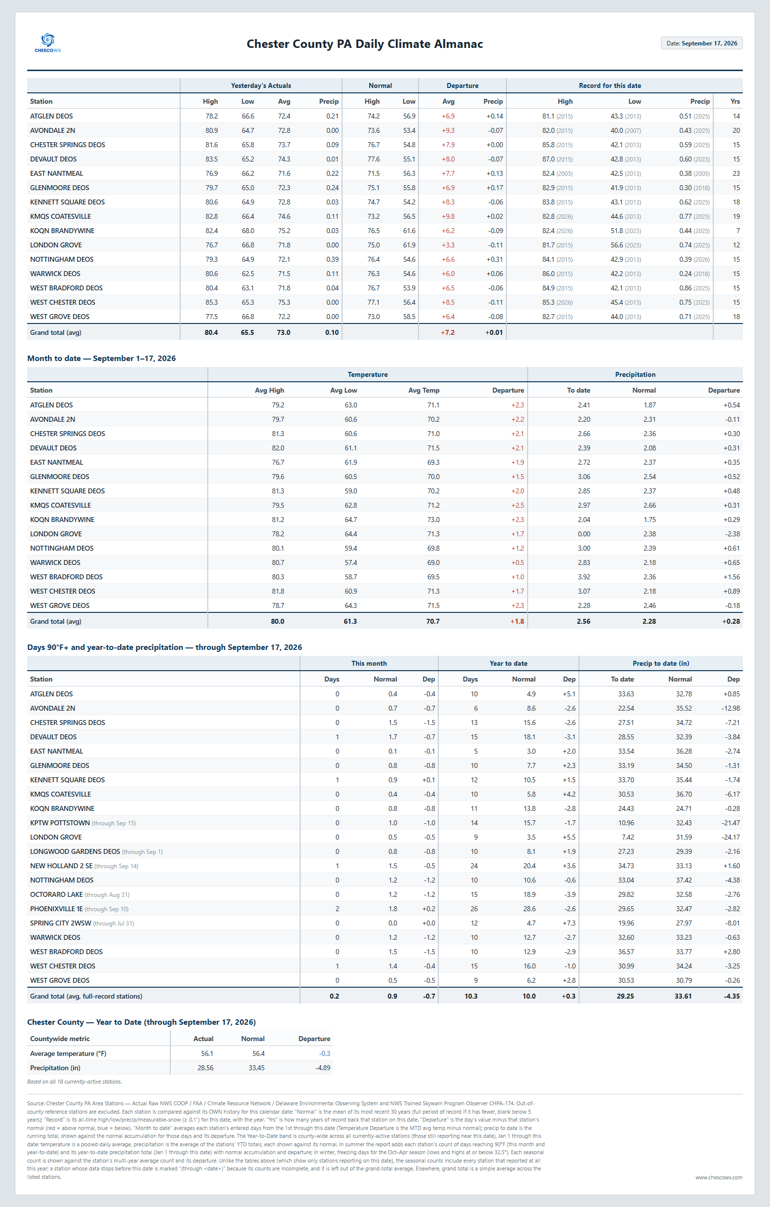
9/17 yesterdays highs: TEB: 87 LGA: 85 EWR: 84 ACY: 84 New Brnswck: 84 PHL: 84 TTN: 84 BLM: 83 NYC: 82 ISP: 80 JFK: *80
-

Septorcher 2026 Discussion - Endless Summer
dendrite replied to Damage In Tolland's topic in New England
Finished with 1.12” -
Going to get some grass seed down on the bare spots tomorrow before the rain. Of course the weeds are prolific as always filling those in…
-

Central PA Summer 2026 Discussion/Obs Thread
WmsptWx replied to Voyager's topic in Upstate New York/Pennsylvania
Forecast high for next Wednesday here in Clearfield: 55°F. Time to dust out the sweats. -
You’re surprised by that given the forecasted rain?
-
Blip
-
thanks, the FRL is the one we are shooting for, going counterclockwise as you described...hope the weather and my knees hold out
-
no flash flooding here
-
I know I'm geeking out right now, but I can't believe that Tool's album Aenima came out 30 years ago yesterday.
-
Euro dried up a good bit at 6z. Typical model dancing. Going from 2”+ to under 1” if it was snow we know the board meltdown would be on lol