All Activity
- Past hour
-
Too bad this snow (or sleet?) won’t last for long. Should melt within a few days, similar to the last one we had 2 weeks ago here
-

Central PA Winter 25/26 Discussion and Obs
Blizzard of 93 replied to MAG5035's topic in Upstate New York/Pennsylvania
CTP has no changes & just reissued this in the last hour… Winter Weather Advisory URGENT - WINTER WEATHER MESSAGE National Weather Service State College PA 951 PM EST Thu Dec 25 2025 PAZ006-011-012-018-019-025>028-034>037-041-042-045-046-049>053- 056>059-063>066-261800- /O.CON.KCTP.WW.Y.0027.251226T1700Z-251227T1200Z/ Potter-Cameron-Northern Clinton-Northern Centre-Southern Centre- Blair-Huntingdon-Mifflin-Juniata-Bedford-Fulton-Franklin-Tioga- Northern Lycoming-Sullivan-Southern Clinton-Southern Lycoming- Union-Snyder-Montour-Northumberland-Columbia-Perry-Dauphin- Schuylkill-Lebanon-Cumberland-Adams-York-Lancaster- Including the cities of Williamsport, Mifflintown, Pottsville, Lock Haven, Newport, York, Danville, Lebanon, State College, Altoona, Emporium, Berwick, Coudersport, Philipsburg, Wellsboro, Huntingdon, Chambersburg, Lewisburg, Mansfield, Carlisle, Lancaster, Lewistown, Shamokin, Sunbury, Hershey, Bloomsburg, Gettysburg, Mount Union, Bedford, Trout Run, Laporte, Harrisburg, Renovo, Selinsgrove, and McConnellsburg 951 PM EST Thu Dec 25 2025 ...WINTER WEATHER ADVISORY REMAINS IN EFFECT FROM NOON FRIDAY TO 7 AM EST SATURDAY... * WHAT...Mixed precipitation expected. Total snow and sleet accumulations up to two inches and ice accumulations up to two tenths of an inch. * WHERE...Most of central Pennsylvania. * WHEN...From noon Friday to 7 AM EST Saturday. * IMPACTS...Plan on slippery road conditions. The hazardous conditions will impact the Friday evening commute. * ADDITIONAL DETAILS...Much of the precipitation could fall as sleet. Sleet and freezing rain can both be dangerous, especially on bridges and sidewalks. They can also weigh down tree limbs and power lines. Power outages are possible. -
Central PA Winter 25/26 Discussion and Obs
Blizzard of 93 replied to MAG5035's topic in Upstate New York/Pennsylvania
Lol, with temps in the 20s & at least .3 of precipitation on the way…? Maybe it will be 80 tomorrow & we can jump in a swimming pool too? -

Central PA Winter 25/26 Discussion and Obs
paweather replied to MAG5035's topic in Upstate New York/Pennsylvania
IMO I don’t think so. -
ICON bumps north a bit - not a huge jump but noticeable
-

Central PA Winter 25/26 Discussion and Obs
mahantango#1 replied to MAG5035's topic in Upstate New York/Pennsylvania
To flurries and sprinkles. -
Does white mean it’s off the chart higher than 24”?
-
Central PA Winter 25/26 Discussion and Obs
paweather replied to MAG5035's topic in Upstate New York/Pennsylvania
Change to what? -
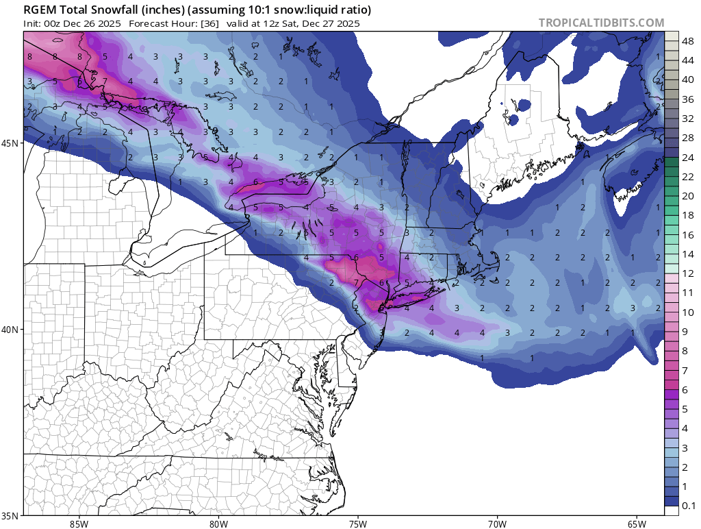
Those are some hellacious snowfall rates just after 0z on the RGEM. Looks like 2"+ per hour for an hour or two. That would cause some serious problems on the roadways for holiday travelers.
-
Company has gone, dishwasher is running and fireplace is still going. Just getting caught up. Nothing over the last 6-8 hours has led me to change my forecast for my area. Still going 3-6". The 3" covers if NAM has a clue and we get mixing out here and the 6" covers .50" liquid at a little over a 10:1 ratio. Feel confident in .40" - .60"qpf. do with those numbers as you wish. Don't see widespread over 6" amounts with the possible exception of the extreme northern fringes of this forum, even there 6" with a few isolated 7 or 8" amounts would be the upper limit, I think. We'll see how it goes. Good luck to all.
-
This has likely been the greatest Christmas of my entire life so far, on so many levels. Merry Christmas to all and to all a very good night!
-
Clear. Breezy. 20.9F
-
Not worried, just discussing weather. I have no control over what happens, just have lived here long enough to know how this usually goes. I'm rooting for us harder than you can imagine, it's normal to be a bit pessimistic given overall trends.
-
Welcome to the Mid Atlantic....
-
The 0z HRRR and NAM had pretty well defined 700mb lows NORTH of Lake Ontario. They keep the circulation alive almost to Ottawa. That's why they push sleet past Binghamton and briefly to Monticello, NY. The GFS has a weaker 700mb low that dissipates more quickly. Hence warm air near 700mb doesn't surge as far northeast, keeping the mixing line much further southwest. We can't know for sure what will happen, but the NAM has a track record with mid-level lows.
-
Why are you worried?
-

26th-27th event, coming at us like a wounded duck.
Boston Bulldog replied to Go Kart Mozart's topic in New England
Gotta wonder how much of the NE edge is virga. Extremely skeptical of those accums in NH. North-south valleys such as the Pioneer Valley may even have some issues too. Extremely cold dry air is going to be advected directly down valley and into the low levels. There are likely to be some maddening discrepancies between radar and reality -

26th-27th event, coming at us like a wounded duck.
40/70 Benchmark replied to Go Kart Mozart's topic in New England
Can already see it this year...one west on 12/2, north last one, even though I got the white xmas, and now southwest...every direction. Next one rainer (north)... -
Rgem

-
Lol. No precipitation
-

26th-27th event, coming at us like a wounded duck.
Go Kart Mozart replied to Go Kart Mozart's topic in New England
For a good time, go through the latest American Skynet run... -
Sorry, I meant Ant and myself. We live in southern Brooklyn and SI respectively.
-
Central PA Winter 25/26 Discussion and Obs
mahantango#1 replied to MAG5035's topic in Upstate New York/Pennsylvania
I wonder if the forecast will change again till tomorrow morning? -
Fun to see a sleet storm, if that’s what we’re facing. Out of our control. .
-
At the risk of causing issues…who is “us”? This is a large geographical forum.