All Activity
- Past hour
-
42.4F. Last 40s for a bit?
-
Euro south again but gfs north. Still hoping it stays north.
-
42 degrees this morning with the high projected at 83 degrees. The deer come through early this morning, probably after a night of raiding people’s gardens.
-
So my May monthly rain total ended up being.... 12.99" One one hundredth of an inch short of 13.
- Today
-
If it’s gonna rain let it pour and let the dams break where they may..of course, as long as everyone is staying safe
-
-
-
it depends on how tropical season sets up
-
Ray you must have done really well in 1993-94 too.
-
January 2016 was like February 1983 on steroids. The added moisture with that storm was definitely CC induced, there was a research paper on it. 30.7 inches of snow with 3.00 inches of liquid equivalent at JFK
-
So we have a few that good winters for both of us. I only listed what I consider A winters. A few of the other ones you listed were B+ here, among them 2004-05, 2008-09 and 2000-01. 2003-04 also fits into that group.
-
48/40.
-
Negative PNA After the lowest daily PNA since 2017, 8 years, in May, the PNA is forecasted to fall below -1 again June would be the 4th consecutive month with negative PNA I rolled forward the March-April-May PNA and April-May-June PNA to the following Winter, to see if it leads anything. Surprisingly, there is no PNA signal the following Winter.. correlation is near 0 in the North Pacific. So to say that this Spring/early Summer PNA is going to lead the Winter is not completely right. There is, however, a NAO signal. Negative PNA March-June puts the probability at about 56-57% that the Winter NAO will be negative [correlation of below maps is opposite] US temps for the following Winter are neutral, for the -PNA rolled forward. About the best you can hope for given the occurrence.
-
 Just another update on contest ... my first stab at May scoring (mid-May) was horrendously bad so if you looked in then to May 31st, and saw those numbers and figured, well, the results will be sort of like that, nope, they were much different (it was much colder in the east and ORD, DEN than projected by me at the time) ... ... those scores are back before some chat about snowfall contest, and the snowfall contest results are back further also. I think DEN is clear of snow risks by now although it could always happen there in June. ... Annual updates are also posted just before this month's forecast posts begin. I will be adding an update on four seasons scoring later (will edit into annual scoring post). I will wait and see who has entered seasonal max by June 7th (edit your posts or re-post as you wish, I have already collected June forecasts). Then I will send messages to any non-entrants who may not be aware there is a call for forecasts. Final note, I have a 2025 N Atlantic hurricane season forecast contest running in the tropical section, some of you have entered already, deadline is June 7th (06z).
 -
__ Table of forecasts for June 2025 __ a separate table will be created for seasonal max ... enter by June 10th FORECASTER _________________ DCA _NYC _BOS ___ ORD _ATL _IAH ___ DEN _PHX _SEA Roger Smith __________________ +3.0 _+3.0 _+3.0 ___ +3.0 _+3.0 _+3.0 ___+1.5 _+1.5 _+1.5 RJay __________________________ +2.5 _+2.5 _+2.5 ___ +2.5 _+1.5 _ +2.0 ___+1.0 _+1.0 _+1.0 hudsonvalley21 _______________ +2.4 _+2.4 _+2.0 ___ +1.4 _+1.2 _ +1.0 ___+0.7 _+2.5 _+0.2 wxallannj _____________________+2.2 _+2.3 _+2.6 ___ +0.5 _ +2.1 _ +1.3 ___+0.7 _+1.8 _+0.7 BKViking _____________________ +2.1 _ +2.2 _ +2.1 ___ +1.9 _ +0.3 _+0.5 ___+1.8 _ +1.0 _+1.9 Tom __________________________ +1.8 _ +1.6 _ +1.7 ____ +1.1 __+1.7 __+0.9___+0.5 _+2.1 _+0.8 ___ Consensus ________________+1.8 _ +2.0 _ +2.1 ___ +1.3 _ +1.1 __ +1.0 ___+0.7 _+1.4 _+1.0 so_whats_happening _________ +1.7 _ +1.6 _ +2.1 ___ +1.4 __+1.1 _ +1.0 ___ +2.1 _+1.3 _+2.1 DonSutherland1 _______________+1.6 _+2.2 _+2.3 ___ +2.6 _+0.2 _+0.8 ___+0.4 _+1.3 _+0.5 Stormchaserchuck1 __________ +1.6 _ +1.8 _ +2.0 ___ +0.8 _+0.6 _+0.7 ___+2.5_+2.7 _+1.0 Scotty Lightning _____________ +1.0 _ +1.0 _ +0.5 ____+0.5 _+1.0 _ +1.5 ___ +0.5 _+2.0_ +0.5 wxdude64 ____________________+0.8 _ +1.2 _ +1.4 ___ +0.4 _+0.8 _+0.5___-0.4 _+0.4 _+0.9 ___ Normal ____________________ 0.0 __ 0.0 __ 0.0 _____0.0 __ 0.0 __ 0.0 ____ 0.0 _ 0.0 _ 0.0 RodneyS ______________________ -0.5 _ +1.1 _ +1.0 ____ -1.8 _ -0.7 _ +1.2 ___ +0.1 _+0.1 _ +1.1 _________________ Persistence (May 2025) _______-0.2 _-0.9 _+0.8 ___ -2.6 _ +0.3 _ +3.2 __ +0.3 _+1.4 _-0.5 ======================================== Highest and lowest forecasts are color coded. Normal has low forecast for NYC, BOS, IAH, PHX and SEA.
-

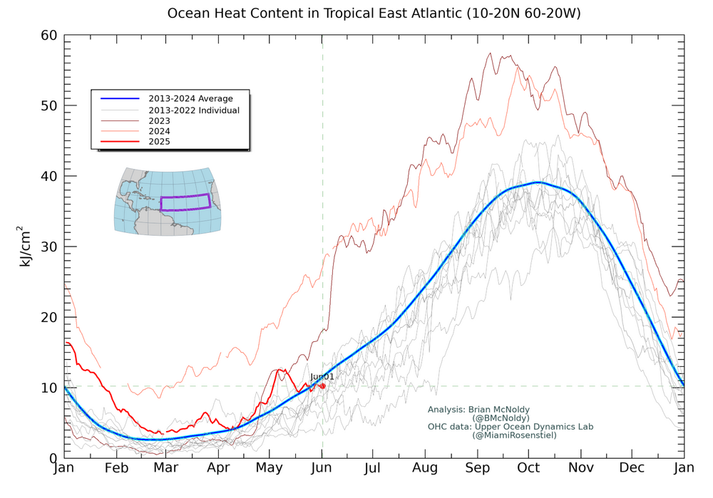
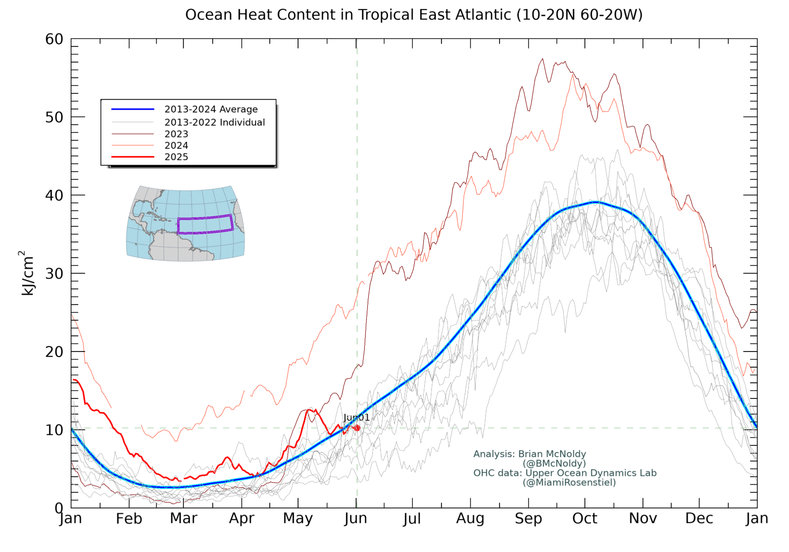
2025 Atlantic Hurricane Season
Stormchaserchuck1 replied to BarryStantonGBP's topic in Tropical Headquarters
Final tallies are in for Apr-May SLP pattern of most active Atlantic Hurricane seasons since 1995: VS ACTUAL Tell me what you think, I think it's close to opposite I think with this the median we can expect this season is 13-14 Named Storms.. of course there are many other factors. -
The latter part of this summer might begin to turn drier but the drier pattern could also hold off until after summer. We'll see. WX/PT
-
2025-2026 ENSO
Stormchaserchuck1 replied to 40/70 Benchmark's topic in Weather Forecasting and Discussion
Negative PNA After the lowest daily PNA since 2017, 8 years, in May, the PNA is forecasted to fall below -1 again June would be the 4th consecutive month with negative PNA I rolled forward the March-April-May PNA and April-May-June PNA to the following Winter, to see if it leads anything. Surprisingly, there is no PNA signal the following Winter.. correlation is near 0 in the North Pacific. So to say that this Spring/early Summer PNA is going to lead the Winter is not completely right. There is, however, a NAO signal. Negative PNA March-June puts the probability at about 56-57% that the Winter NAO will be negative [correlation of below maps is opposite] US temps for the following Winter are neutral, for the -PNA rolled forward. About the best you can hope for. -

2025-2026 ENSO
michsnowfreak replied to 40/70 Benchmark's topic in Weather Forecasting and Discussion
I frequently talk on fb to a former poster from here who lives on Long Island and I definitely see how different the weather is and is to predict. It's crazy for me to talk to a fellow snow lover who had seen several 30" snowstorms in his lifetime yet in recent years gets excited if grass tips are covered. That's such a wild climate. Believe me we get plenty of model mayhem here, but the sheer magnitude of some of the storms that models see hitting the coast that never materialize, or the ones that can sneak up on you is crazy. And i imagine the mixing scenario must be maddening, once models lock in mega qpf but disagree on a mix line. We still get clippers but seems like not as many as we used to. A clipper is actually usually a fun thing to track because some will surprise you with great dynamics and a boost when it crosses the lakes (but just as many others peter out to crap). I love cutters, swfe, and bowling balls...then the unpredictability of lake squalls in the storms wake. So as long as we get the goods im never one to piss and moan when you guys get hammered. -
2025-2026 ENSO
michsnowfreak replied to 40/70 Benchmark's topic in Weather Forecasting and Discussion
Good point. But I was determined to make that list until I ran into a 1990s winter lol (anyone from here will tell you how superior 2000s/2010s winters were to 1990s). I could also arguably put 2020-21 ahead of 1998-99, but the paralyzing snow of Jan 1999, coming after a snowless Fall and anemic 90s winters was a sight to see. Then we had another snow blitz in Mar 1999. -
Pick the warmest and driest model. Ez game.
-
2025-2026 ENSO
michsnowfreak replied to 40/70 Benchmark's topic in Weather Forecasting and Discussion
All of those great except the infamous nightmare of 1995-96. Funny story. In 1994-95 (I was 11) i would sneak outside and measure snow on the back porch and my dad would get mad thinking I was tracking snow in. But the next winter my mom said I could measure with my budding interest in weather, so that began my now 30 winters and counting of continuous snow record (I bought a house a mile from my parents so my record is basically the same location). So 1995-96 was my inaugural year. In the years before internet and stuff i primarily relied on TWC. And i remember vaguely seeing coverage of these monster snowstorms and I kept thinking, why is everything missing us? I ended up with 31.3" but 12" of that came in March, including a 7" power crusher on March 20th. Even in January it was hard to enjoy back to back 2-inch snowfalls knowing they were originally forecast as big storms for us that veered south last minute. In the years since I was able to figure out how the pattern really was, and im SO glad I've never seen anything like it since! -
50/44. Everybody is ready for some warmer weather.
-
For the record, that was intended as an em dash, not a negative sign.
-
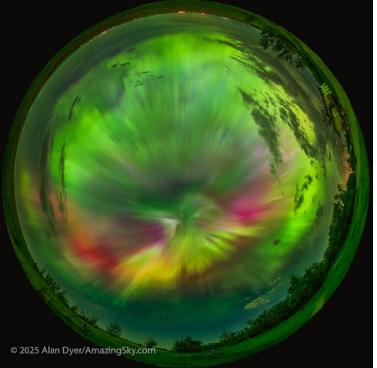
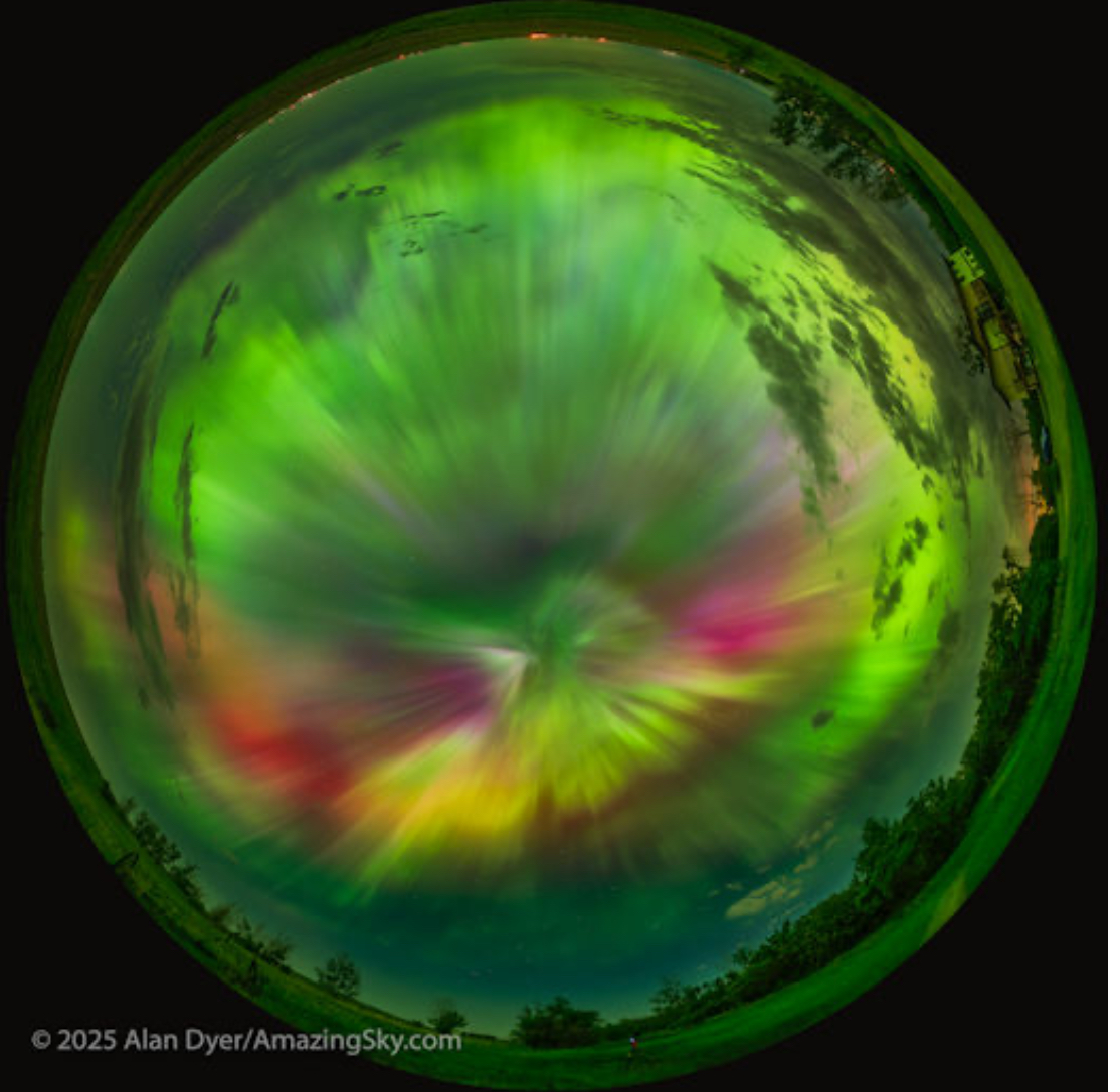
I just checked the semi-dark spot near me where I took the photos last year, but there are too many clouds around.


.thumb.png.4150b06c63a21f61052e47a612bf1818.png)


