All Activity
- Past hour
-
Thankfully we don’t get many in the summer anymore.
-
 This is so bad bro we're all going to have lung cancer
 -
Yeah it's funny it's a really cool illusion
-
Today will be the 9th consecutive day without measurable rainfall at the airport, assuming nothing pops up (there were a few scattered showers earlier north). Only 0.39" over the past 21 days.
-
 It isn't. The angle does make it look that way though haha
 -
Swing low, sweet chariots.
-
 march 2035: "well it wasn't a blockbuster winter but at least we had those 3 nights that got below freezing"
 -
 Nothing will get fixed if people still act like this is a USA problem. Just like you won't solve your budget woes by cancelling Netflix while keeping the 800 dollar a month car lease.
 -
Skeptical hippo here that this is going to somehow magically turn into a very active Atlantic hurricane season with high ACE. I’m feeling confident sticking with my guess of below normal
-
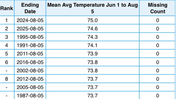
2nd warmest summer to date at the airport site (1953-present), behind last year. 1995 had a very warm August, however, and is the warmest summer on record at PIT. We’d need to average close to 77 the rest of the way to get there. Not impossible. Top 5 seems clinched.
-
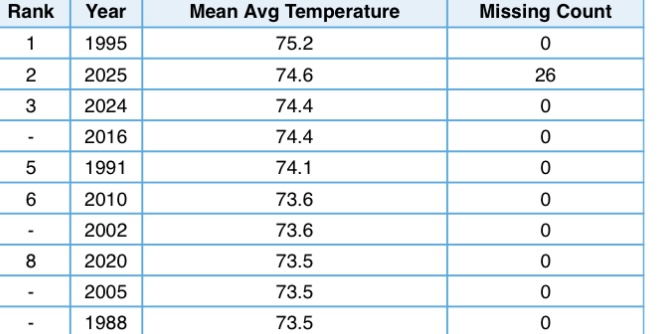
 With July now in the books below is the Average Temperature Trend for Chester County PA from 1893 through 2025...mighty flat!!
-
MLCAPE of 4500 to 6000 near Fargo ND tomorrow..Yikes..I’d lust for that here. Probably not even feasible in these parts?
-
I understand that most/all the fires are in remote, nonpopulated areas, but at what point is this considered "pollution" as there's lots of people in the mid west and elsewhere being effected by this healthwise. Can't they even attempt to squelch some of the fires?
-

2025-2026 ENSO
Stormchaserchuck1 replied to 40/70 Benchmark's topic in Weather Forecasting and Discussion
With 61% of the period complete, it's at +0.20 for DJFM NAO. Given the 0.54 sd, which has hit 11-9 since inception in 2005, it has a 50% probability of being in the range -0.34 to +0.74 Winter NAO. -
 why is it on the ground?
 -
Theater kids…the worst! Yeah. Some trees are shedding leaves. Not really to different but noticeable
-
We had two days of decently BN 850 temps Friday and Saturday. Then N to AN through today. Another mild down Thursday into Friday and then we AN through September aside from a mild down for a day or two.
-
yes, breathe in that smoky Canadian air. refreshing
-
is that Mars? It got larger or closer since I last saw it.... and where are the Martian polar ice caps? are they melting too?
-
Like a set of saggy boobs ?
-
One more day of this tomorrow before we clear out. I've been keeping my air conditioning on 24/7 it seems to filter out the smoke and keeps me from coughing.
-
Looks like we will be seeing more westerly flow I think this is a cyclic change back to our hotter summers and expect to see more of this in future summers.
-
With us heading into another Niña I wonder if we’re in this dryness for the long haul? Usually things turn dry between August and October in Niña years and the pattern doesn’t usually break until the Niña does in February/March. Though this past year it actually strengthened and lasted an extra 2 months.
-
1918 - Unusually hot weather began to overspread the Atlantic Coast States, from the Carolinas to southern New England. The temp- erature soared to an all-time record high of 106 degrees at Washington D.C., and Cumberland and Keedysville hit 109 degrees to establish a state record for Maryland. Temperatures were above normal east of the Rockies that month, with readings much above normal in the Lower Missouri Valley. Omaha NE reached 110 degrees. (David Ludlum) On this date the highest ever maximum temperature of 107 °F was recorded in Richmond, VA. (Ref. Richmond Weather Records) This must have been when the historic 104 degrees occurred- back in 1918, right after our coldest winter ever in 1917-18. 1881: Smoke from Michigan forest fires created a yellow pall over the Northeast. Candles were necessary for light at noontime. (Ref. AccWeather Weather History) See it's entirely different when the smoke comes from another state vs another country lol What happened in 1881 to cause this?
-
Small victory yes I'll agree


.thumb.png.4150b06c63a21f61052e47a612bf1818.png)


