All Activity
- Past hour
-
 Please add the link, if possible.
 -
The Euro seasonal SST anomalies don't really line-up w the NA pattern. AN SSTs in the centiral IO imply convection which spreads into the Maritime Continent. @nrgjeff@Daniel Boone@Met1985@John1122@GaWx@Math/Met what is causing those big blocks over NA w/ the Pac and IO basins being meh? If I didn't tag you, please don't be offended. Feel free to jump right in. I know some folks from other forums might also have some input. If you don't have access to SST maps, I can post those.
-
 Yup and they last till NOV
 -
Like the CANSIPS seasonals which were just released, the Euro seasonals show decent signals for HL blocking for Dec-Jan. That would fit nicely with a weak La Nina. No, I haven't checked SSTs yet for the Euro.
-
Wait, there is more....that would be a double block. Some zonal underneath, but that would very likely get the job done.
-
I’m going to Hilton Head from Thursday-Wednesday. Looks kinda bleh most of the time with that tropical system possibly threatening after we’re gone. We were down there last year for Debby, so I don’t really care to do it again.
-
Yep. That will do it.
-

2025 Atlantic Hurricane Season
RaleighNC replied to BarryStantonGBP's topic in Tropical Headquarters
great time to reduce staff at the NHC and reduce Hunter flights, huh? -
Every SSTA map is different from the rest. Insane how much they vary and I suspect explains, in part, why long range model solutions vary early on in the forecast period with greater variations later in the forecast periods.
-
 I don’t see why we can’t reach 100 for many of us if we get another stretch of WNW downslope heat. Especially since like you said we’re not getting much rain over the next 5-7 days. Topsoil dries out very quick this time of the year as we can see with the browning lawns.
 -
 September sucks because of yellowjackets
 -
hmm every 2 days the GFS has an over top +PP doing the Ontario-Quebec transit though. Those are all BD cautions with that model. Euro not so much. So yeah, it's otherwise dog-days of summer tendency in the model runs lately, sure. There's also a tropical signal based on climatology with pattern analog stuff. The models don't key in on climate, more so their physical detection is describing how/why the climate analog stuff evolved the way it had. Either means of prognostic suggest something coming along ... But Scott's right about the EPS and frankly I'm not seeing very climo friendly look overall for any such system to be an issue here. You want a -D(nao) on the western limb, with some sort of establishing S/N steering all the way up.
-
 87 amd despite the milky haze a decent amount of sun today
 -

2025 Atlantic Hurricane Season
BarryStantonGBP replied to BarryStantonGBP's topic in Tropical Headquarters
-
12z guidance (and going back to overnight runs) mostly want to washout the SE coast tropical low or pull it northeast out to sea. Either option looks good to me!
-

2025-2026 ENSO
Stormchaserchuck1 replied to 40/70 Benchmark's topic in Weather Forecasting and Discussion
CPC subsurface continues to be much different from TAO/Triton.. it's holding a warm pool in the western-central subsurface, below the dateline. -
details TBD but looks like a prolonged above average dewy stretch summer as it should be
-

E PA/NJ/DE Summer 2025 Obs/Discussion
RedSky replied to Hurricane Agnes's topic in Philadelphia Region
Nature is cruel it's dry and virtually nothing in the 10 day -
2025 Atlantic Hurricane Season
BarryStantonGBP replied to BarryStantonGBP's topic in Tropical Headquarters
-
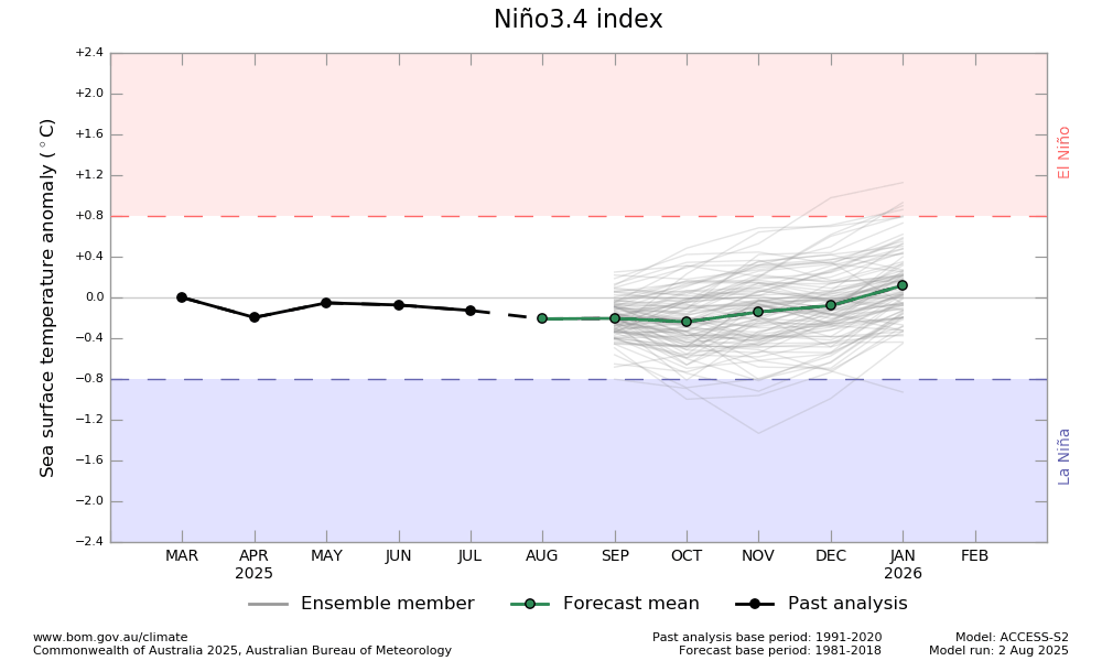
The BoM released 8/2/25 has -0.2 for ASO and then rises to near 0.0 for the winter: Colder boat needed here too probably.
- Today
-
Central & Eastern Pacific Thread
BarryStantonGBP replied to Windspeed's topic in Tropical Headquarters
Would be history if it happens -
 Sea breeze boundary w LI. Showers now at 250 pm
 -
2025 Atlantic Hurricane Season
BarryStantonGBP replied to BarryStantonGBP's topic in Tropical Headquarters
-
 There was an interesting article re: the subterranean blob of molten mantle moving south west under New England, aged 80 million years from when Greenland broke off. Maybe that is impacting the old fault lines?


