All Activity
- Past hour
-
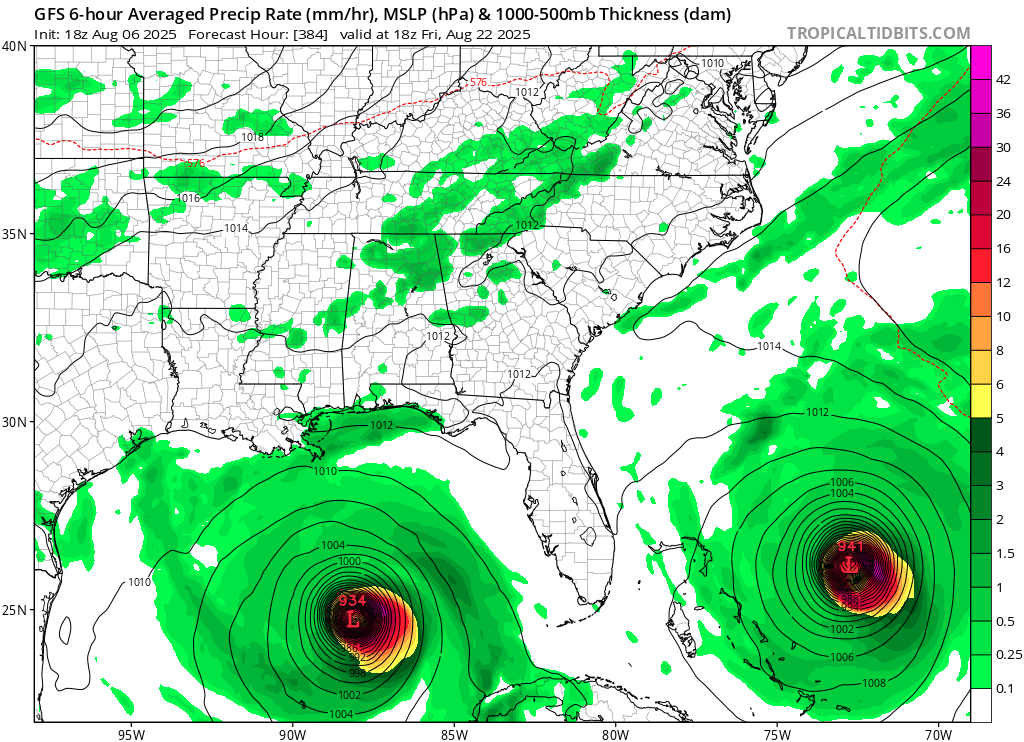
From yesterday. I know it's hr 384 but it got my brain going. Is there any historical precedent for what's shown, two sub 950mb canes approaching the SE simultaneously?

-
 I know we are way in advance here, but how’s the end of the month looking? preferably Labor Day weekend. I’ll be at the shore.
 -
 We've had almost no rain here since the flooding a few weeks ago. The ground is very dry and I'm having to water the vegetable garden often. Next week looks rough with very little chance of rain during the big heat wave. The grass will be burning out. I know Walt was talking about a potential flash drought a couple days ago. I hope we're not heading towards a drought like what happened last year at the end of the summer and the fall.
 -
 without a doubt
 -
All I needed to see was 2014....I just ignored the rest of the years lol.
-

2025-2026 ENSO
40/70 Benchmark replied to 40/70 Benchmark's topic in Weather Forecasting and Discussion
2021-2022 ended up okay for most, but more often than not you are right. -

2025-2026 ENSO
PhiEaglesfan712 replied to 40/70 Benchmark's topic in Weather Forecasting and Discussion
I hope we get a good blocking pattern in November/December. The pattern that's in place early in a -ENSO/-PDO winter usually sets the tone for that winter. If we don't get a good blocking pattern early, the winter is toast. -
 Dry conditions expanded heading into the heatwave next week. https://droughtmonitor.unl.edu/CurrentMap/StateDroughtMonitor.aspx?Northeast Northeast Drought Summary Very warm weather with persistently below normal precipitation for the past few weeks has allowed short-term moisture deficits to develop in a number of locations. Conditions have been the most anomalous across northern New England and far Upstate New York, where several areas of abnormal dryness (D0) were introduced. D0 was also brought in to parts of the immediate southern New England coast. A small area in southeastern New Hampshire and adjacent Massachusetts saw D0 conditions eradicated after 1 to 2.5 inches of rain fell this past week, but robust precipitation was not common across areas of existing dryness. Short-term precipitation deficits were also emergent in parts of New Jersey and Pennsylvania, but no dryness designation seemed appropriate yet, although these areas will need to be monitored for deterioration in the next few weeks if precipitation doesn’t return to near normal.
 -
2025-2026 ENSO
40/70 Benchmark replied to 40/70 Benchmark's topic in Weather Forecasting and Discussion
Wife is from Uganda and has family there....she is orchestrating the construction and managing it...I've just assisted by procuring the funding. -
I’m just thrilled to see the sky as the smoke appears to be gone-hallelujah!
-

2025 Atlantic Hurricane Season
BarryStantonGBP replied to BarryStantonGBP's topic in Tropical Headquarters
-
managing a property from oversees? hmmm
-
2025-2026 ENSO
40/70 Benchmark replied to 40/70 Benchmark's topic in Weather Forecasting and Discussion
Should be great....we are just finishing up an 8 unit housing complex to fuction as an Air b & b. -
 the BDR reading is taken at the airport which sits on a penisula out into the sound-sound water temps are at least mid 70's so can see how they stay elevated this time of year at nighttime
 -

2025-2026 ENSO
Stormchaserchuck1 replied to 40/70 Benchmark's topic in Weather Forecasting and Discussion
Have fun in Africa! -
Hate to do it but that's what they're there for right?
.jpg.eedaa845185c7a488002bf2b6a5fc435.jpg)
.jpg.7b66d6fd090408f21290a4988486b07a.jpg)
-
Just think...one of these years we're going to get a super strong EL Nino where we are ripping 70's in DJF...for multiple days. EWR probably hitting a 90 too.
-
Dews and heat here soon enough. Big big summer stretch coming. Poor Moregarbage.
-
We are working to eliminate those too.
-
SE Area of Interest--10% two day, 30% five day odds
BarryStantonGBP replied to WxWatcher007's topic in Tropical Headquarters
NHS think this not too surprised -
extratropical storm dexter
BarryStantonGBP replied to BarryStantonGBP's topic in Tropical Headquarters
L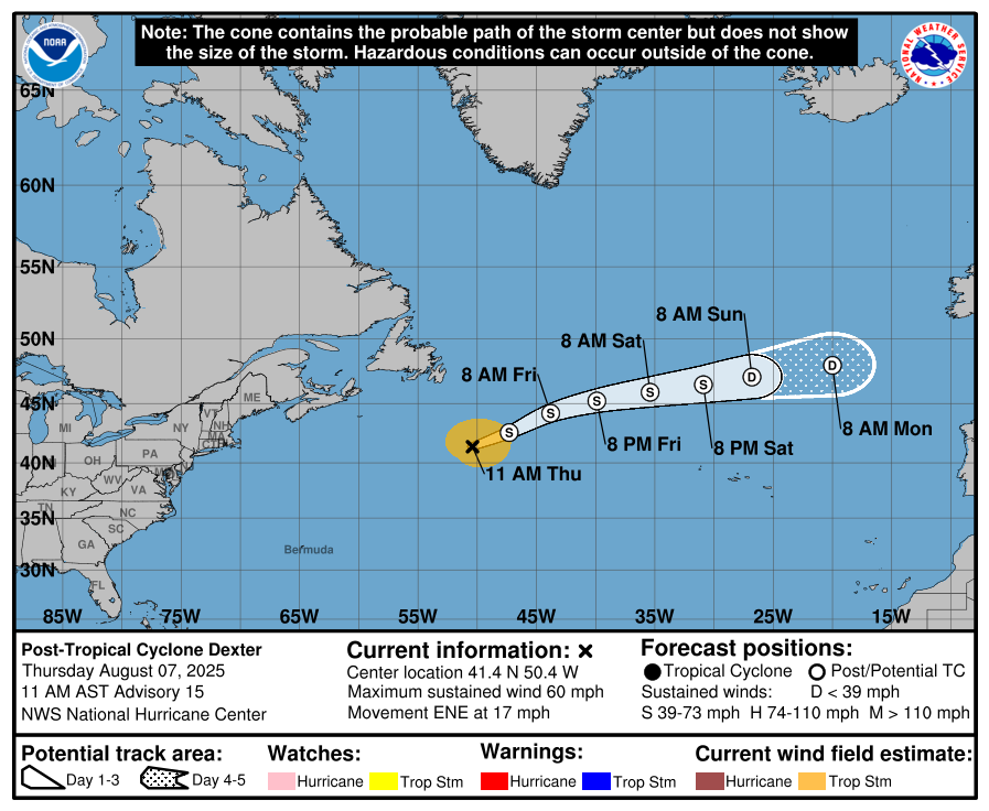
-
 I've been talking about shipping regulations boosting temps for a couple years. The general cleanup of air since the 1990s also contributed big time. And then we also have Hunga Tonga which of course just had to be a massive water vapor booster into the stratosphere instead of an aerosol release.
 -
see what happens when dews are low?
-
Yeah I can see those. Thanks!
-

2025 Atlantic Hurricane Season
WxWatcher007 replied to BarryStantonGBP's topic in Tropical Headquarters
Not to get on a gatekeeper high horse lol but you can definitely justify a thread and analyze as an experienced poster here. Barry (god love ‘em) starting a thread on anything that swirls with an op that is devoid of original information for readers isn’t helpful imo.