All Activity
- Past hour
-
Months and months…
-
NWS State College: .SHORT TERM /6 PM THIS EVENING THROUGH MONDAY NIGHT/... The widespread stormy and unsettled pattern resumes Monday with a shortwave trough and subsequent falling heights progressing through the Great Lakes, putting the Commonwealth back in the warm sector as deeper moisture is pulled north. Partly cloudy skies to begin the day on Monday will allow for plenty of destabilization. This combined with the above mentioned moisture return and increasing deep layer shear of around 25-30 knots will provide the ingredients for another round of strong storms Monday afternoon/evening. Strong outflow winds and heavy rainfall look to be the primary threats.
-
7/5 - 7/9 : stronger heat potential with some cooler candian air to the north. Heat could be focused mainly to the south of us persistently, but spikes look to come north at times.
-
Overall the same but slight wrinkle Wed Pm - the thu fourth AM 7/2 - 7/3: Warm - hot , humid - 80s - low 90s, storms potential Wed evening/Thu early 7/4 : any storms clear by the early morning, clears out - dry 79s - 80s 7/5 - 7/6 : Warm - hot, humid, stronger heat possible by the weekend, storms possible
-
A trace of rain yesterday. Monthly total so far 5.38.
-
Man euro is a summer look. We take.
-
Records: Highs: EWR: 102 (2021) NYC: 101 (1934) LGA: 98 (2021) JFK: 99 (1959) Lows: EWR: 56 (1968) NYC: 52 (1919) LGA: 59 (1995) JFK: 55 (1995) Historical: 1826: Thomas Jefferson made his last entry in his weather observation log on this date, just six days before he died. The weather held a fascination for Jefferson as he made regular weather observations. He bought his first thermometer while working on the Declaration of Independence and his first barometer shortly after that. 1878: The weather observer on top of Colorado's Pike's Peak noticed that a major storm remained stationary over South Park, some 50 miles away. The observer also noted that the whitened ground from hail could be seen until sunset. (Ref. Wilson Wx. History) 1899: A great flood occurred on the Brazos River in Texas. The flood waters reached a width of 12 miles and caused $10 million dollars in damage. (Ref. Wilson Wx. History) 1907: A tropical storm moved from the Gulf of Mexico to coastal North Carolina, where it dissipated. The remnants moved north and combined with a cold front moving in from the Ohio valley, producing two days of widespread severe weather through the 29th. In some areas, rainfall amounts ranged from 3 to 6.73 inches, producing flooding that exceeded the flooding of tropical storm Agnes in 1972. Thunderstorms also produced high winds, hail and tornadoes, including F2 tornadoes at Edgemont, PA where debris from a destroyed garage was carried three-quarters of a mile away. Eight people were killed, six by drowning in swollen streams or rivers.(Ref. Wilson Wx. History) 1931 - The temperature at Monticello FL hit 109 degrees to establish an all-time record for the state. (The Weather Channel) 1943" Minimum temperatures were above 75° from 23rd to 28th in Washington, DC and greater than 70°F on June 20th-29th. (Ref. Washington Weather Records - KDCA) 1954 - Hurricane Alice dumped as much as 27 inches of rain on the Lower Rio Grande Valley of Texas. The Rio Grande River at Laredo reached a level 12.6 feet above its previous highest mark, and the roadway of the U.S. 90 bridge was thirty feet below the high water. (David Ludlum) 1962: Flooding in Wichita Falls, TX resulted in a quarter million dollar loss in city equipment, man hours, and other city property. The official rainfall total at Sheppard Air Force Base was only 1.64 inches, but other reported rainfall included 2.60 inches in downtown Wichita Falls, and from 4.20 to over 5 inches at Charlie, in northern Clay County. An estimated 300 cars were stranded temporarily on highway 287 near Jolly, when sections of the highway were flooded by over two feet of water. (Ref. Wilson Wx. History) 1975: Near Kingsland, Ark.--Lightning struck and killed a 6-year-old and injured her aunt while they were on a family outing on the banks of the Saline River. (Ref. Lightning-The Underrated Killer.pdf) 1987 - Thunderstorms produced severe weather in the Ohio Valley and the Great Lakes Region, with reports of large hail and damaging winds most numerous in Ohio, Indiana and Michigan. Thunderstorms spawned four tornadoes in Michigan. A tornado near Clare MI was accompanied by softball size hail. In Colorado, an untimely winter-like storm blanketed Mount Evans with six inches of snow. (The National Weather Summary) (Storm Data) 1988 - Alpena, MI, reported a record low of 39 degrees while Jackson, MS, equalled their record for the month of June with an afternoon high of 105 degrees. Thunderstorms in the central U.S. soaked Springfield MO with 3.62 inches of rain, a record for the date. (The National Weather Summary) 1989 - Thunderstorms produced severe weather in the Southern and Central High Plains Region. Thunderstorms in Colorado produced softball size hail at Kit Carson, while pea to marble size hail caused ten million dollars damage to crops in Philips County, CO. (The National Weather Summary) (Storm Data) 1990: A microburst wind estimated around 150 mph did extensive damage in the town of Streamwood, in the Chicago metro area in Illinois. At least $10 million dollars damage was done to 25 stores and industrial buildings. Radar and eyewitness accounts indicated no rain or thunderstorms in the immediate vicinity of the area at the time. (Ref. Wilson Wx. History) 1993: Flash flooding rolled across southeast South Dakota and into northwest Iowa. A phenomenal 6 to 7 inches of rain fell in Dickinson and Emmett Counties during a 3 to 4 hour period. The Des Moines River rose several feet in just a few hours. Ocheyedan received 3 inches in just 45 minutes and Allendorf picked up 2.80 inches in 30 minutes. Many locations in northwest Iowa reported winds in excess of 60 mph, with some locations clocking speeds of 70 to 80 mph. Several tornadoes were also spawned during the evening in Emmett County in the Ringsted area, 3.50 inch hail fell and baseball size hail covered the ground just north of Estherville. Millions of dollars in damage was caused from the thunderstorms across the area. 1993: No river traffic was moving on the 585 miles of the Mississippi River from St. Paul, MN to Cairo, IL and on 535 miles of the Missouri River from Sioux City, IA to the point it joined the Mighty Mississippi. More than 5, 000 loaded barges were stranded. For the first time in history, major floods came down both rivers at the same time. (Ref. Wilson Wx. History) 1994: Persistent extreme heat in the Southwest as Arizona 128°F at Lake Havasu City and Nevada 125°F at Laughlin set all-time record high temperatures on the same date. (Ref. Lowest and Highest Temperatures for the 50 States) 1998: "The Corn Belt Derecho of 1998" in the following states NE, IA, IL, IN, KY. A derecho which originated in far southeast South Dakota moved across Illinois during the afternoon and evening and continued as far east as Ohio the next morning. Every county in central Illinois sustained some damage, as these severe thunderstorms passed. Winds gusted in the 60 to 80 mph range, with some localized microbursts producing winds more than 100 mph. Significant damage occurred in the microburst areas, including the towns of Morton, McLean, LeRoy, and Tolono. In Tolono, 22 cars of a southbound 101-car Illinois Central freight train were blown off the tracks. It was unknown how many vehicles were picked up by the wind, but 16 cars were turned over, and another six derailed but remained upright. The train was en route to Centralia from Chicago with a load of mixed freight, including plastic pellets and meal. The freight cars empty weighed about 60,000 pounds, while a full one weighs about 260,000 pounds. Overall, 12 people were injured, and damage was estimated at around $16 million. 2003: Tropical Storm Bill made landfall south of Houma, LA with top winds of 60 mph, spreading a six foot storm surge across the low lying portions of the Louisiana Coast. For the second time in two years, the town of Montegut, LA was flooded after the town’s protection levee was breeched. Bill dumped 5 to 8 inches from Louisiana to Alabama. A tornado at Reserve, LA injured four people. (Ref. Wilson Wx. History) 2005: Heavy rains of 3 to 7 inches fell across far eastern Brown, western and northern Day, and most of Marshall Counties in South Dakota during the early morning and again in the afternoon hours. One location measured 5 inches of rain in two hours. In Day County, 30 roads were washed out and 15 bridges were damaged. Some rainfall amounts include 5.04 inches in Britton, 3.34 inches north of Columbia, and 2.08 inches at Aberdeen. Total June rainfall for some locations in Marshall and Day Counties was between 11 and 12 inches. The flooding continued into early July before receding by July 10th. (Ref. Wilson Wx. History) 2012: The maximum temperature today was 103 °F at the Richmond International Airport a new record maximum temperature for the date. The old record was 101 °F in 1980. (Records since 1897) The maximum at the West Henrico Co. - Glen Allen station was 102 °F at 4:20 PM. It was the hottest day here since July 22, 2011 when it was also 102 °F. Friday's derecho, a widespread and long-lived violent thunderstorm complex, affected millions of people from Chicago, Ill., to Washington, DC. Strong winds, in many cases in excess of 70 mph, downed numerous trees and power lines from Illinois to Maryland. Over 2 million people were left without power. Winds with derecho -- 86 mph at Wintergreen Mt., 80 mph at Roanoke Airport 71 mph, Dulles 70 mph at Reagan, National 59 mph in Richmond International Airport and only 37 mph in West Henrico Co. - Glen Allen VA. (Ref. Derecho Hits Ohio Valley, VA, MD See Map (Ref. Violent Storms Virginia, Maryland, D.C (Ref. Derecho Damage- 32 pages Worth of Damage Reports 2012: Fifth of the top ten weather events - Mid-Atlantic and Midwest Derecho. June 29. The widespread severe winds associated with the band of rapidly moving thunderstorms (a derecho) left a trail of destruction from Illinois to the mid-Atlantic, leaving some 4.25 million homes and businesses without power, killing 24 people, and costing hundreds of millions of dollars in property
-
Storms all around me for hours yesterday afternoon through evening. Got scraped by one just to the north finally. Picked up .4 from some huge drops, all the while looking at broken clouds and sun in the sw skies. Frustrating.
-
FYP
-
81 / 73 sunny. Race to any clouds / storms popping, otherwise Florida style heat today upper 80s / low 90s. Sam for Monday and Tuesday with storms perhaps more widespread into later mon evening and Tue, hot /humid both days upper 80s / low 90s in the hotter spots. Wed the GFS and Euro now drive a mcs within the trough that looks to bring storms Wed evening into the early morning of the fourth but looks to clear. Other runs had this into New England but perhaps a speedier version to last Sunday with any storms/rain in / out to make way for a gorgeous (drier/cooler) fourth upper 70s - 80s. By next weekend heat and humidity building back north and east and it looks like spikes of heat by the 7th - 10th with cooler canadian air nearby by and the sauna below, looks overall warm - hot but some moderation between spikes of stronger heat. 6/29 - 7/3 : Hot / Humid - storms potential focus on Sun PM - Tue - Wed night 7/4 : Any storms clear out, gorgeous dry/ warm 70s - 80s 7/5 - 7/6 : Warm / Hot - humid - heat building back 7/7 - 7/10 : Hotter 7/11 - Beyond - Warm - hot , interludes of strong heat, moderation (caught between canadian cool / sauna)
-
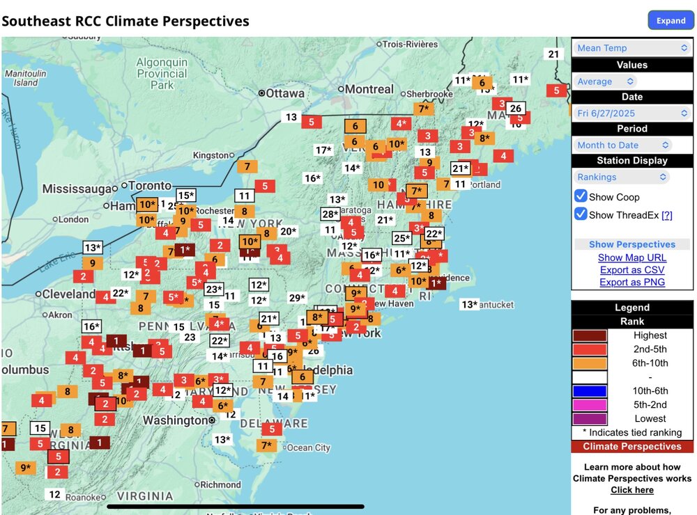
Another top 10 warmest month for the Northeast.
-
The hottest 24 hour period at Central Park has to be July 5-6, 1999 with a high of 101 and a low of 83 (and a high of 101 again the following day.) It's absolutely amazing that 1908 had lows of 84 in both July and August, that must have been one hot summer! July 1995 is right up there too with a high of 102 and a low of 84 and extremely high dew points. September 11, 1983 is notable for having a high of 99 and a low of 78, mid summer weather in mid September. April 2002 is notable for lows in the mid to upper 70s and highs in the mid to upper 90s.
- Today
-
If you go by 24 hour periods of highest average temperature would you say that the July 5-6, 1999 period was the hottest 24 hour period on record at JFK, Don? The high was 102 on July 5th and the low the following morning was 82! June 24-25 comes in second place with a high of 102 and a low of 81 the following morning. It ranks higher in terms of duration because June 25 also had a high of 102 while July 6th fell below July 5th highs (only at JFK, at NYC it was the same as the previous day, at 101.) I'm surprised that July 2011 isn't on this list, as JFK had back to back highs of 103 and 102 in that stretch so the lows must have been elevated also. It's also interesting how highs made it into the 90s from a start in the low 60s in April 2002. And I knew May 1991 was extremely hot with 7 90 degree days but didn't know that we had our earliest 70 degree low in that month! That period at the end of August 1948 was also notable with a high of 101 and a low of 78.
-
Stein really settling in now in most of SNE
-

Central PA Summer 2025
Mount Joy Snowman replied to Voyager's topic in Upstate New York/Pennsylvania
Back home from camping. Low of 69 with 1.3” of rain. Perfect summer day on tap today, great for pools or boats. -
Farther north, stronger shear will be present from Pennsylvania northward. This may result in greater storms organization including the potential for a few supercells with a threat for large hail and damaging wind gusts. Mid-level lapse rates will be weak (<6 C/km) which will be the primary limiting factor to greater severe weather probabilities across portions of the Northeast.
-
boring weather in summer, who could possibly have guessed?
-
Boring looking pattern. Maybe we can get some storms on Tuesday.
-
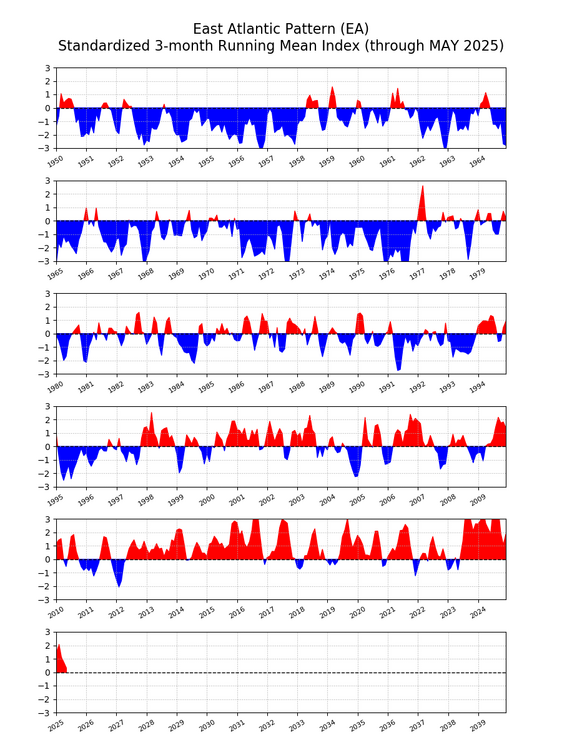
My guess is that this that the expanding subtropical ridges across the planet from Japan to the Eastern US and Europe as the climate warms are driving these multiple records. Notice how the EA has become so positive over time. So the +NAO could be driven by the expansion of these ridges. Plus the feedback from the record marine heatwaves east of Japan across the Atlantic to the Mediterranean. Mika Rantanen @mikarantane.bsky.social · 1d The Mediterranean is now warmer than it typically was in August during the recent 1982–2015 climate period. And it’s no wonder when you look at the atmospheric circulation: a strong upper-level ridge has parked over the western Mediterranean, allowing the marine heatwave to develop. ALT ALT 1 11
-
69 degrees this morning,and picked up .74” of rain in a storm that come through yesterday afternoon.
-
73 for the low and up to 75 already with full sun. Another special summer night...
.thumb.png.80a92fddbf533923d66d03a592144f64.png)
-
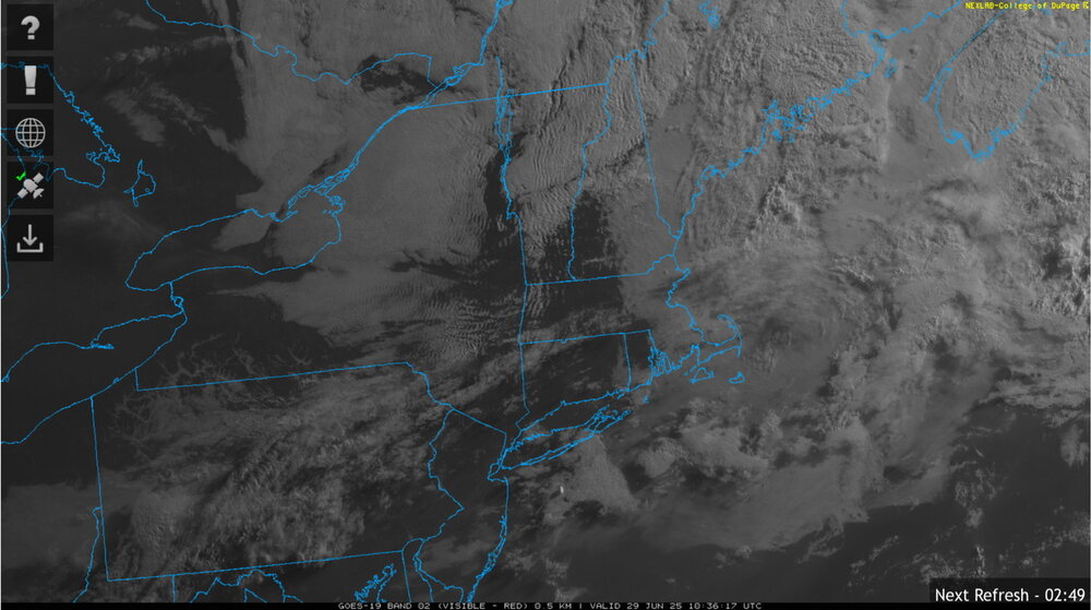
Vis probably shows the true boundary better

-
It’s like Christmas morning, except about 6 hours of daylight tacked on!
-
I’m so glad to hear you have them. I had a lot last year, but zippo this year.
-
We fog.


.thumb.png.4150b06c63a21f61052e47a612bf1818.png)


.png.8e0f0836a03a1d192244bd65dc8c151f.png)