All Activity
- Past hour
-
Full snowcover here. Was surprised to see so much of it stick after today.
-

E PA/NJ/DE Winter 2025-26 Obs/Discussion
Ralph Wiggum replied to LVblizzard's topic in Philadelphia Region
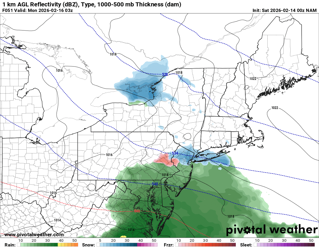
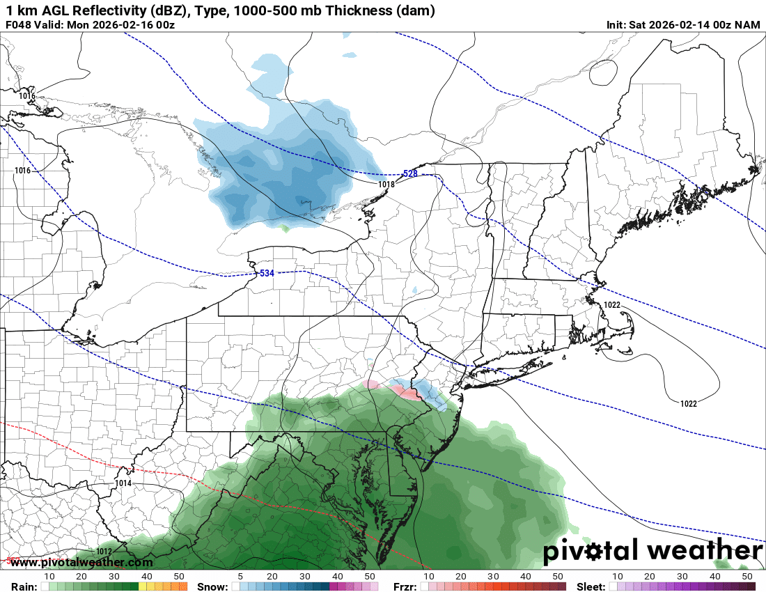
12k NAM came way north for the late weekend system. Appears warmish at the start. -

-

Is we back? February discussion thread
WeatherGeek2025 replied to mahk_webstah's topic in New England
Nam is way north, I don't think this is done trending north either! -
Nam only jumped a few hundred miles north

-
Yeah I am still at 100%. I would like to make it to 20. Tomorrow is going to make it tough
-

Winter 2025-26 Medium/Long Range Discussion
McHenrySnow replied to michsnowfreak's topic in Lakes/Ohio Valley
Probably as good as we're going to get going forward. Next winter already looks like a nightmare with el nino. Only positive in a warming planet is the occasional monster storm, but lengthy periods with a solid snowpack in northern illinois are increasingly unlikely. -
what i think will happen

-
Really good winter. Cold and snow pack longevity, at least one big storm. Below normal temps Dec-Feb but needs one more good storm (6"+) to move this winter from a B to an A. Snowfall currently near average Feb has 2 weeks left so we'll see if it can deliver something otherwise it'll be a solid B winter. March weather is always extra to me.
-
February 2026 OBS & Discussion
WeatherGeek2025 replied to Stormlover74's topic in New York City Metro
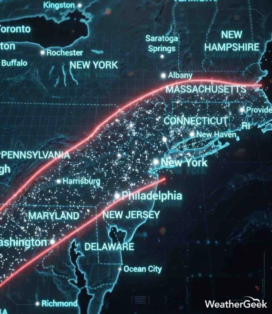
Because of the Bermuda High pressure, this could realistically partially phase and have snow break out between 6-9 hours depicted on the map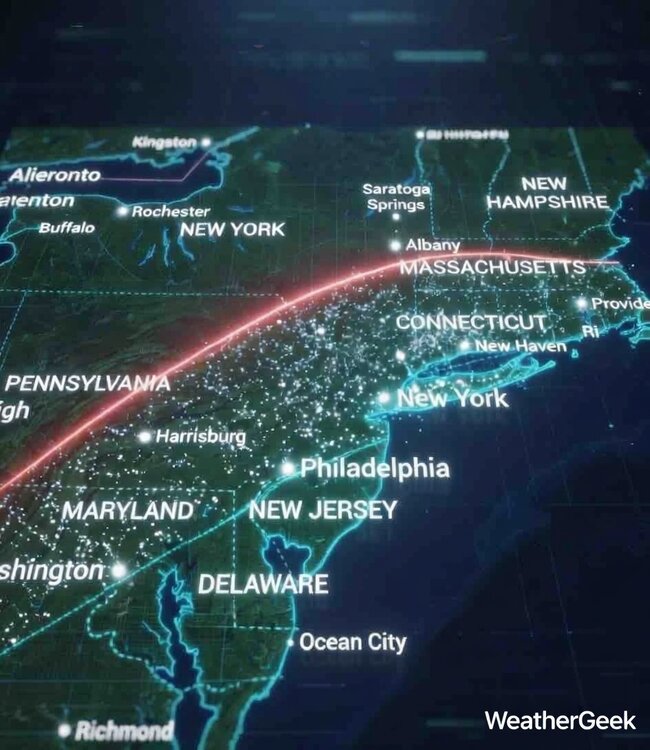
-
Is we back? February discussion thread
WeatherGeek2025 replied to mahk_webstah's topic in New England
this isn't exact science but because of the Bermuda High pressure being stronger than modeled and trending even stronger could phase the northern stream and cause the snow to break out for 6-8 hours between this area!
-

Central PA Winter 25/26 Discussion and Obs
Jns2183 replied to MAG5035's topic in Upstate New York/Pennsylvania
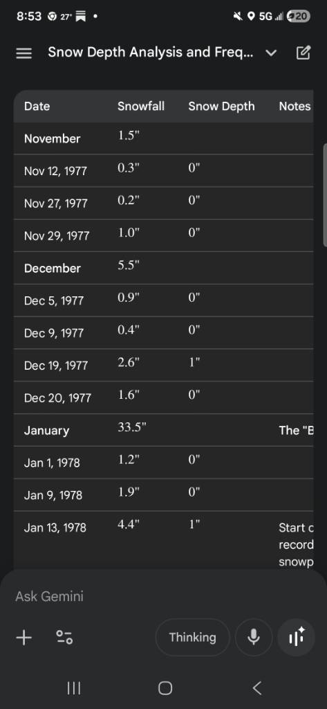
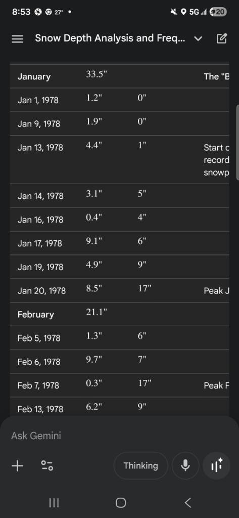
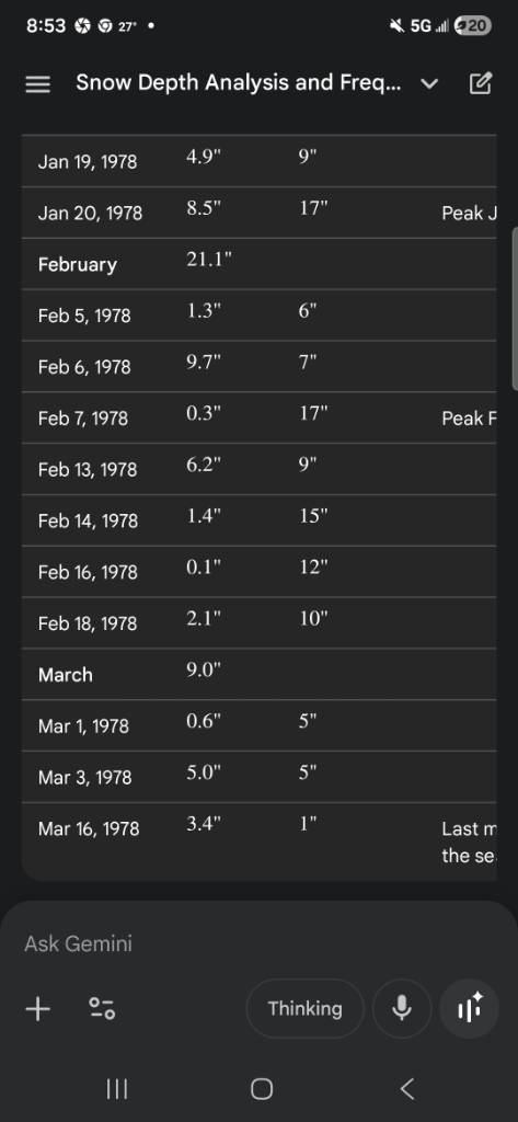
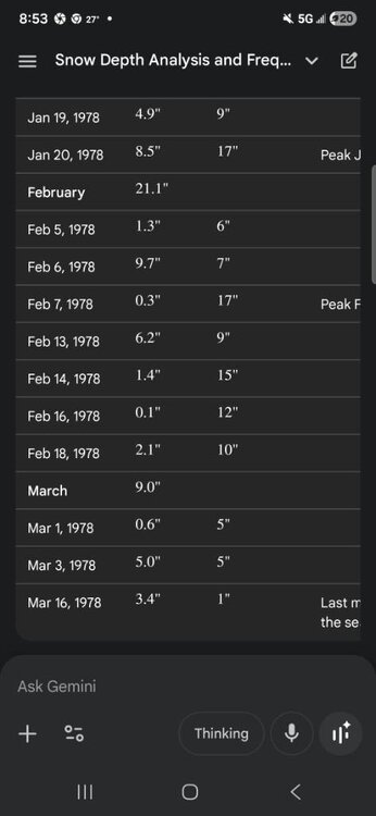
Winter of 93-94 holds the record here. 76 days straight of snow on the ground. Jan 4th to March 20. 1977-78 was also a banger. 66 days straight. Jan 13- March 19th. Take a look at the images for the beauty that winter was. It was also frigid. Average daily temperature Dec 31.6 Jan 26.2 Feb 22.8 March 38.6 Sent from my SM-S731U using Tapatalk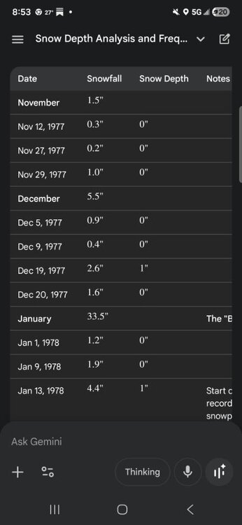

-
Looks like a gradient pattern is setting up with waves along a boundary.
-
Sunday-Monday storm is expected to slide out to sea due to the negative PNA and zonal flow, this isn’t really an explosive coastal setup. Next week looks better, no big storm but multiple waves along a boundary. It can add up quickly.
-
Central PA Winter 25/26 Discussion and Obs
Jns2183 replied to MAG5035's topic in Upstate New York/Pennsylvania
At this point I have to laugh. I'm starting to feel better but noticed I couldn't taste anything today. Took COVID test, positive of course. I'm sure I picked that up in hospital Sent from my SM-S731U using Tapatalk -
That was the sentiment at the time AREA FORECAST DISCUSSION..FINAL AFTN.. NATIONAL WEATHER SERVICE TAUNTON MA 414 PM EST SUN MAR 4 2001 ...SEVERE STORM COMPARABLE OR WILL EXCEED THE BLIZZARD OF 78 FOR SNE WITH 60 HR DURATION OF SNW AND MAX INTENSITY OF WORST CONDS 18Z TUE-00Z WED AND HURRICANE FORCE WIND GUSTS ARE HIGHLY LIKELY TO OCCUR PARTS OF E MA COAST...DRAG
-
Pittsfield FTW!! Or the bright blue skies.
-

Is we back? February discussion thread
RUNNAWAYICEBERG replied to mahk_webstah's topic in New England
Bruh… -
Eta, Avn, NGM, NOGAPS People think the NAM and HRRR is bad, they have idea about the NGM
-

Central PA Winter 25/26 Discussion and Obs
canderson replied to MAG5035's topic in Upstate New York/Pennsylvania
Interesting- it’s water streams and puddles everywhere around HBG/Camp Hill. I actually splashed my pant leg walking into Costco tonight -

E PA/NJ/DE Winter 2025-26 Obs/Discussion
MGorse replied to LVblizzard's topic in Philadelphia Region
The Global High-Resolution Atmospheric Forecasting (GRAF) model is a propriety, physics based, numerical weather prediction system developed by The Weather Company (an IBM Business) in collaboration with the National Center for Atmospheric Research (NCAR). -
Definitely looks north. H36 streams are oriented closer to each other, may show some interaction in the later frames.
-
0Z HRRR is going to be north and wetter. At least we will get some rain out of this I think.
-
Is we back? February discussion thread
WeatherGeek2025 replied to mahk_webstah's topic in New England
maybe for you but not for coastal sections, also that bermuda High Pressure has been trending stronger the last few runs, watch it send the Low pressure way north and have it rain up to Toms River and Snow up to Pittsfield MA! Itll also make the Low pressure go through a phenomena called Bombogenesis! -
Storm is gone more interested in the 18th beyond