All Activity
- Past hour
-
History tid bit of the day. In 1743 London had 700,000 people and 7000 gin distillery. England had about 6 million people, 2.4 million under the age of 15, 3.6 million over. They managed to drink 8 million gallons of 40% gin that year. The epidemic became so bad that many many places paid wages strictly in gin Sent from my SM-G970U1 using Tapatalk
-
Pouring in norton
-
Torrential here for last 45 minutes…
-

September 2025 OBS-Discussion centered NYC subforum
bluewave replied to wdrag's topic in New York City Metro
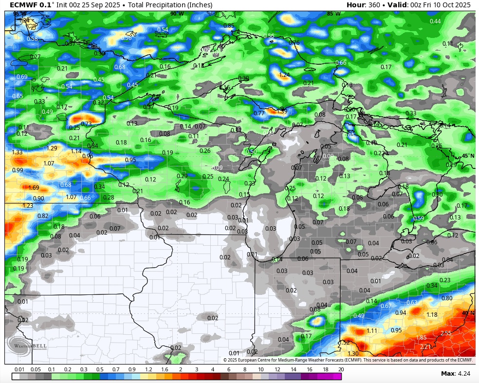
The new RRFS A has been maintaining that trajectory for days now with the heaviest focused to our NW. It’s still considered an experimental forecast so doesn’t really get included in the mix during forecast discussions. It could be that the warmer conditions with the record 70° lows resulted in the front stalling a little more to the NW of the very wet models like the Canadian suite focusing the max right through our area. So the stalled front would up further north than the wetter models. -
It can snow plenty here in a warm overall winter. We don’t need end to end frigid conditions. We just need the Pacific pattern to cooperate in windows of a few weeks to allow for good storm tracks while there’s half decent cold to work with. We don’t benefit from the storm track types that can still dump plenty for I-90 or even I-84.
-

September 2025 OBS-Discussion centered NYC subforum
WestBabylonWeather replied to wdrag's topic in New York City Metro
Well……it rained a little bit. -
Days and days
-

September 2025 OBS-Discussion centered NYC subforum
Sundog replied to wdrag's topic in New York City Metro
Up to a whopping 0.14 here after this last batch of scattered rain showers moved through. -

Fall 2025 Medium/Long Range Discussion
cyclone77 replied to Chicago Storm's topic in Lakes/Ohio Valley
Exciting times ahead.
-
September 2025 OBS-Discussion centered NYC subforum
Sundog replied to wdrag's topic in New York City Metro
The trajectory of the precip to our west and southwest looks like it will take it northwest of our area. I hope something else blossoms that could give everyone a nice soaking as opposed to this ultra scrattered popcorn crap. -
Comes up where?? The CTRV?
-

2025-2026 ENSO
40/70 Benchmark replied to 40/70 Benchmark's topic in Weather Forecasting and Discussion
This is why I reference my forecasts....if you are going to make blanket statements about my perceptions that are inconsistent with what I am forecasting, then perhaps you should read them. I am favoring +WPO, dude...and explicitly mentioned that this caps seasonal snowfall potential. The hope is that its a more subdued +WPO as it was in 2017-2018, which is manageable and not prohibitive to heavier snows for at leas the northeast. -
2025-2026 ENSO
40/70 Benchmark replied to 40/70 Benchmark's topic in Weather Forecasting and Discussion
I'm not claiming that you specifically have a question about my forecasts per se, but when you feel compelled to explain to me how difficult it has been to sustain "wall to wall DJF -EPO -WPO patterns since 2018-2019", the tacit inference is that you feel as though I am under the impression that this will happen in 2025-2026. -
Tis the perfect day for the English tradition perfected by William the Orange at the start of the 18th century of a tumbler of gin Sent from my SM-G970U1 using Tapatalk
-

Central PA Summer 2025
Mount Joy Snowman replied to Voyager's topic in Upstate New York/Pennsylvania
Low of 68, .09” of rain, and a lush looking lawn. -
With the persistent onshore/easterly wind I had a few tenths of “below the radar” precip from evening through early morning hours yesterday before the main precip moved in. Fog/mist turned to mist/light rain for an all day wet vibe. This was the first solid consecutive wet days in a while.
-
Why do you think I am talking about your forecasts? If I had a question for you then I would ask you directly. The negative modes of those indices weren’t strong enough last winter to prevent the storm tracks on the wettest .20+ precipitation days from Philly to Boston from cutting through the Eastern Great Lakes. Your perception of those modes were from a colder era when they were more effective at driving colder storm tracks to our south when the Pacific Jet was weaker. For the general pattern since 18-19 to change we would need to see the Pacific Jet relax and stop producing the cutter, hugger, and suppressed Southern Stream storm tracks. Hard to believe our last effective wide scale relaxation of this pattern was in January 2022 with the great MJO 8 pattern.
-

September 2025 OBS-Discussion centered NYC subforum
jm1220 replied to wdrag's topic in New York City Metro
Have maybe 0.1” here. This may get the total up to 0.5”. -

September 2025 OBS-Discussion centered NYC subforum
SnoSki14 replied to wdrag's topic in New York City Metro
It won't develop until it gets into the Bahamas -
We picked up .47 since midnight. Grass is already starting to green up a little. Picked up 1.06” for the week so far.
-
They're getting smoked. Acushnet area too
-
Moderate to heavy rain in Marysville currently with .22 since midnight. Total since yesterday is .32 so far.
-
Storms for all?
-
September 2025 OBS-Discussion centered NYC subforum
bluewave replied to wdrag's topic in New York City Metro
It’s certainly underperforming model forecasts as this dry pattern since last fall has been very persistent.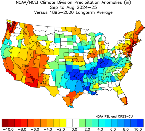
-
Friend texted it was pouring buckets. I’m so happy!!!