All Activity
- Past hour
-
Euro 6z with its best run yet!
-

December 14th - Snow showers or Plowable snow?
moneypitmike replied to Sey-Mour Snow's topic in New England
The rare GON to HYN win. -
Are we aiming for suppression?
-

12/14: Sunday funday? Will the south win again?
Ralph Wiggum replied to TSSN+'s topic in Mid Atlantic
Anyone have the latest Rufus (future Nam replacement)? -

Minor snowfall sunday 12/14/25 1-4” possible
Yanksfan replied to WeatherGeek2025's topic in New York City Metro
Good to see the 6z models improved over the 00z runs. 3-5” is a good call right now. One more bump north and we will be in warning criteria snowfall. -

Central PA Winter 25/26 Discussion and Obs
mahantango#1 replied to MAG5035's topic in Upstate New York/Pennsylvania
Me too, 19 here now, but last night it got down to 13 here -

December 2025 regional war/obs/disco thread
mahk_webstah replied to Torch Tiger's topic in New England
The place is magical. I keep telling the weenies to go up for a few days. -
December 2025 regional war/obs/disco thread
mahk_webstah replied to Torch Tiger's topic in New England
Shove that se Canada low 250 miles ne -
Some sort of CAD wedge will develop and we’ll be stuck at 45 degrees and drizzle all day. Book it.
-

December 14th - Snow showers or Plowable snow?
BrianW replied to Sey-Mour Snow's topic in New England
Yeah. So serene. Looks like a nice deep winter feel here on the shoreline for a few days. SHORT TERM /6 PM THIS EVENING THROUGH MONDAY NIGHT/... Key Points: * 1 to 4 inches of snow are expected across the area tonight into Sunday morning, with up to 5 inches in eastern Long Island. * Winter Weather Advisories have been expanded slightly west and north to include all coastal zones from 10pm tonight through 1pm Sunday. * Windy and cold Sunday night into Monday morning with wind chills below zero in some areas.
-
-
Although it still favors north as last night's 3z run, the 9z run of the Rap would be acceptable to most I think.
.thumb.png.6aa9919e8b669233ae25130e3b2a4e49.png)
-
Today’s temp max seem to be playing a bigger part than most modeling indicated before last night.
-
6z Ukie maintains the northern idea fwiw
.thumb.png.e48553ac7ccd1155b845b01f6bf9935f.png)
-
The nams seem worthless to change that much so close to game time
-
Saturday night/Sunday 12/13-12/14 Jawn
Ralph Wiggum replied to Ralph Wiggum's topic in Philadelphia Region
I went 2-3" in general Friday morning with 4" pockets and see no reason to deviate. Pretty straightforward little system. -

Central PA Winter 25/26 Discussion and Obs
Voyager replied to MAG5035's topic in Upstate New York/Pennsylvania
CTP busted high with my forecast low. They said 16. At 3:00am I dropped down to 10.8 -

Minor snowfall sunday 12/14/25 1-4” possible
Bxstormwatcher360 replied to WeatherGeek2025's topic in New York City Metro
6z gfs also improved, bumped up the snow totals a bit.nam also.. -

Central PA Winter 25/26 Discussion and Obs
pawatch replied to MAG5035's topic in Upstate New York/Pennsylvania
15 degrees this morning. Don’t even look like it is even going to make it above freezing until Tuesday. Looks like most of the precipitation is staying to the south of us this year. Virginia is having a good year. Myself I just get up, and deal with whatever the snow gods leave me. -

12/14: Sunday funday? Will the south win again?
Weather Will replied to TSSN+'s topic in Mid Atlantic
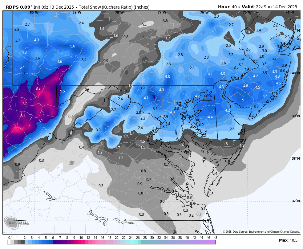
Hugging the Canadians:WB 6Z RDPS
-
Wait! You can Still watch the old fashioned scrubbed forecasts!?!?
- Today
-
Strong gradient like pattern. Some models showing Arctic ridging. If the gradient can slip south every now and then for latter Dec and Jan then it could get interesting. I'd feel better being north though
-

Minor snowfall sunday 12/14/25 1-4” possible
SnoSki14 replied to WeatherGeek2025's topic in New York City Metro
This mornings Nam got better compared to 0z. Think 3-5" looking better and better. Some areas may even approach 6" in South Central NJ. -
Holding steady at 15F here, nice cold ground ahead of this little event. Looks like SEMA is gonna pick up the most in NE and I’m happy for those guys, they’ve been getting screwed as much as the NYC area lately. Hopefully this is a nice little event for everyone. I think LI down to my area should do pretty solid, hopefully it ticks up for NYC also.
-

Minor snowfall sunday 12/14/25 1-4” possible
RU848789 replied to WeatherGeek2025's topic in New York City Metro
Best RFFS run yet. It must be correct, lol.


.png.d369fa9bd7cba10bde2c8c89073068ab.png)
.png.7612cdddf2ab6c478b81c999e37f6db7.png)