All Activity
- Past hour
-
My poor dog is totally gone wake up soon with the thunder. I swear she has a sixth sense for when storms are approaching too. My poncho is ready!
-
Decent storm…lots of lightning.
-
We bang.
-

2025 Atlantic Hurricane Season
WxWatcher007 replied to BarryStantonGBP's topic in Tropical Headquarters
I think this is it. Too far north and you’re dealing with cooler SSTs and inherently more stable/dry air due to proximity to the Sahara and subtropics. IMO there were robust waves coming off too far north that reinforced SAL during the climatological peak for SAL, and stability even as SAL declined. The further south waves fared much better, especially after SAL pushes weren’t as potent in the tropical Atlantic. I think that can be much less pronounced this season during peak, but I don’t know. - Today
-
Brief tiny downpour moved thru yonkers.
-

2025 Atlantic Hurricane Season
LongBeachSurfFreak replied to BarryStantonGBP's topic in Tropical Headquarters
That’s it, increased dry stable air at the mid levels. Destroys lapse rates as there isn’t as much change in temp with highl. Very counterproductive for general thunderstorms that are needed in early development. You can have all the spin in the world. Ideally you want the waves to exist as far south as possible in the most moist top to bottom environment. -
Can already hear thunder
-
Just had a random loud crack of thunder, woke me up. Strange, no rain either.
-
Incoming:
-
Hey @WxWatcher007, wasn’t there a theory that that mid season quiet period of 2024 was related to the ITCZ being so far north? I didn’t necessarily buy it and actually thought it was counterintuitive due to increased coriolis force further N of the equator, which itself should be positive for TCG. Do you buy that theory? Wasn’t it said by those agreeing with that theory that the so far N ITCZ had increased Saharan/dry air incorporated into the AEWs?
-
Isn't there a pretty well documented increase in C/EPac trade winds over the last 40+y? I'd think that (plus the aerosol pattern effect) would have a pretty drastic effect on SST patterns and the downstream Pac climate indices. Also probably can't get away from the insane post-2020 NPac/NAtl warming (N Hem in general) and the effect it's already having on the position of the ITCZ/monsoon trough via response to differential warming.
-
I think NYC receives its first shot of heat sometime between May 17th-24th. It just seems to be timing out that way with eventually a high pressure ridge settling over the eastern mid west and the east. Hinted on long range GFS and Euro. WX/PT
-
Hey Tony, -You have a unique and excellent way with words, always entertaining! For example, I love the way you described the airport as essentially being oblivious to reality. Hilarious and pretty much spot on at times! Your posts often have a poetic quality to them. I and I’m sure Shack and others look forward to your posts as much as anyone’s. -There is no love lost between the airport and you and that’s quite understandable. Regardless and realizing their clear deficiencies, I still do like to look back at airport stats because they’re pretty much the most readily available for detailed Atlanta area official stats going back many decades. Thus they’re great input for my abacus. My abacus would do better if the airport were more reliably reflecting reality, but oh well. -In all fairness to the airport, it did report a trace of snowfall on 4/3/1987. Per @Shackwhat Griffin got, flurries in April, was truly amazing. But doesn’t that sound similar to the airport’s trace? -I was then living just outside the Perimeter not far from I-85 in Dekalb. I was absolutely mesmerized by this event. In my area, I followed the snow as it approached (via TV/radio), and I was so excited when it arrived. It was rain that changed to snow from W to E. I recall it snowing in Cobb a good bit before finally reaching Dekalb. As I recall, it did start sticking to roofs, cars, and grass soon after starting in the morning (not to pavement). Unfortunately, I think it went back to rain at some point after the short period of snow while it remained snow in Cobb and other areas further west. -That was a fantastic winter with 3 snows: ~5” of beautiful heavy wet snow in late Jan (biggest there since 1983), a rare 1-2” snow in mid March, and then this early April miracle. -Tony, where were you on 4/3/1987?
-
swingggg and a miss.
-
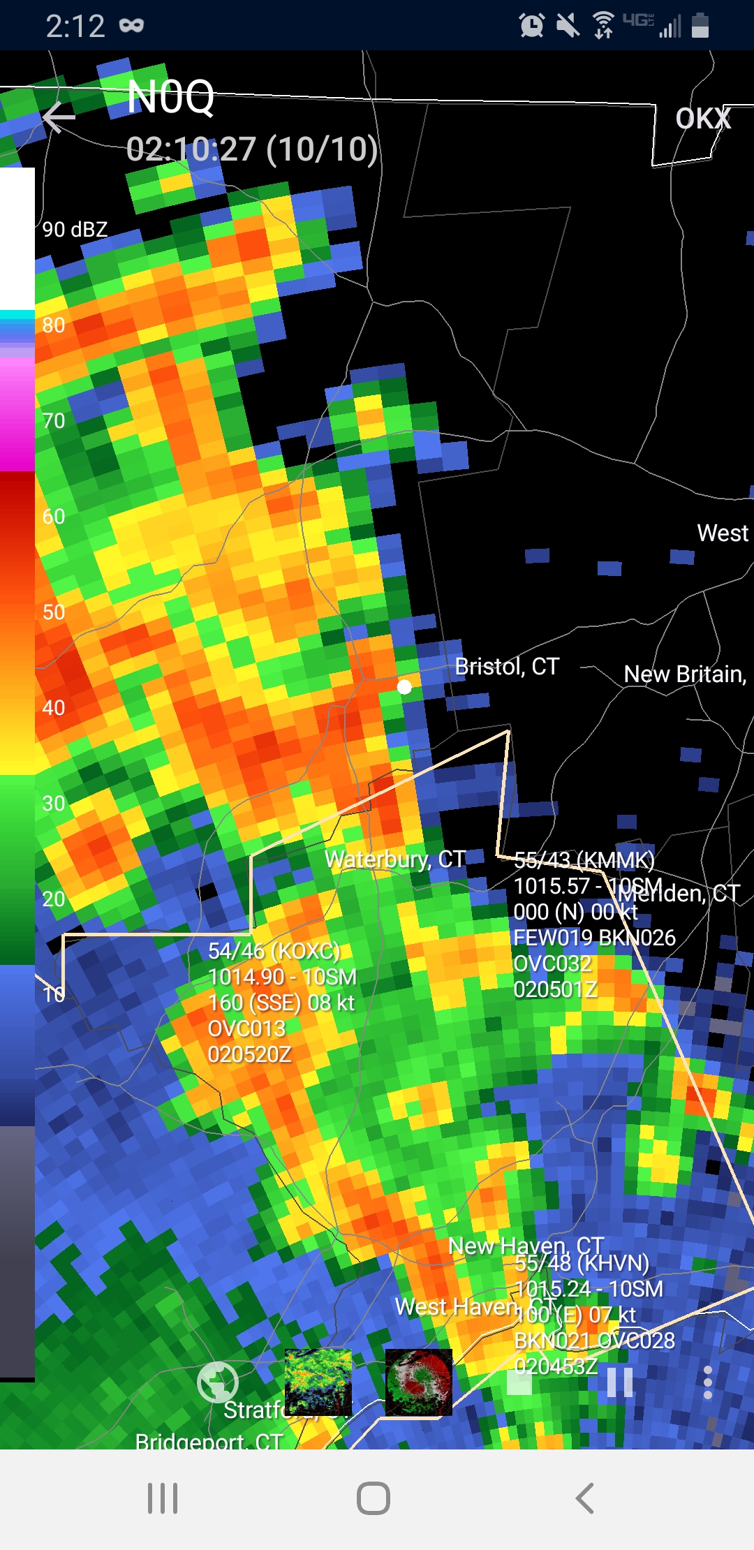
I see 2 little cells that popped up. One in Bergen one over Queens
-
Well that was an unexpected crash of thunder...
-
Some opening thoughts.
- 1 reply
-
- 1
-

-
2025 Atlantic Hurricane Season
WxWatcher007 replied to BarryStantonGBP's topic in Tropical Headquarters
Just going to make some blanket comments here. It's indisputable that there are numerous factors that determine whether a season is active or not. SSTs and OHC are just one piece of the puzzle and I think @cptcatz is right that they're often leaned on too much, but they are still a significant piece. SSTs should warm up some, as mentioned by the discussion earlier. That's not really where my caution flag lies. For me it's not just the tropical Atlantic SSTs that are important, the subtropics as well. This distribution has me concerned that the stability issues we've seen this decade will persist into the 2025 season. Now, that hasn't proven to stop the exceptional stretch of activity we've seen since 2017, but it's something to pay attention to considering possibly less ideal atmospheric conditions this season with the lack of a full blown Nina. We only need to look at last season and the historic lid that was placed on the entire basin due to SAL and systemic stability reinforced by an active AEW train as an extreme example of what can happen. Is there anyone willing to say right now that 60W to 20W won't have at least some problems with SAL and stability? There are still open questions about the WAM, how much the Pacific cools, and the actual ENSO that controls this summer/fall. I don't think it's unreasonable at all to throw up caution flags, even while leaning toward another above normal season. I don't think that's "mainstream" or whatever, it's looking at the evidence right in front of us. @jconsor, agree that the S&P forecast is interesting, though I am still skeptical of those kind of LR forecasts and their skill. Doesn't mean the science isn't being pushed forward though, which would be awesome to see. I do agree that we probably have a higher than normal likelihood for an active landfall season, but I'm not willing to paint landfall zones because idk if the skill is truly there outside of a month at most. @GaWx, I don't think we need SSTs to approach the last two years for a higher end NS season, but I do think we need an expansive region of high OHC for this year to produce higher end H and MH numbers. That's there, though not nearly to the extent of the prior two years. -
GFS likes Saturday afternoon
-
5" over a few days would actually be quite beneficial. We all know what normally happens on LI in the summer. Also we have to see how it evolves. Could be a few days of mostly raw misty crap on easterly wind while the real rain is west.
-
Griffin often gets stuff the airport doesn't, Shack Of course the airport often doesn't know what's happening all round it, lol. Hope all is well with you!!
-
May has arrived and preseason is here! That means it's time for the legacy thread. The Atlantic has been exceptionally busy since 2017, but it has thrown several curveballs over that period that has led to unexpected outcomes in the basin. Last year, after the earliest category 5 hurricane on record, we saw a historically quiet start to the climatological peak of the season, followed by a historically active back loaded season. This year, we do not have the same warmth and depth across the basin as 2024, but with a neutral to cool neutral ENSO likely--which would facilitate periods of low wind shear, a cooling Pacific, and still warm SSTs in the western Atlantic, another average to above average season is likely IMO. However, a major thing to watch is the cooler SST distribution in the tropical Atlantic which may not only temper the ceiling in that part of the basin, but also potentially continue the dramatic stability issues we've seen this decade. Last year, I was in Texas for Beryl, Louisiana for Francine, and Florida for Helene. The Gulf has been ground zero since 2017. We'll see if that continues this year. Beryl was the first storm where I had my window blown in Francine nudged east at the last minute and I missed the worst. Still a solid storm. Helene was the real deal. With 2024 in the books, I've now completed 16 tropical chases.
- 1 reply
-
- 2
-
-

2024-2025 La Nina
Stormchaserchuck1 replied to George001's topic in Weather Forecasting and Discussion
My last biggest storm was 5.5" on Nov 15, 2018. Can you believe that. I also think every year has been below average since 15-16. There was a some major warming happening though around the perimeters in 14-15 and 15-16.. Dec 15 was record warm. 14-15 was record warm in the West. And last Winter had the opposite: some cold around the perimeters. Hopefully we are changing into a better pattern for the next few Winters. -
I fervently hope you guys get happily buried ALIVE in powder snow soon!
-
Looks like the rain is later Saturday, I have a dumpster to clean the house out to get ready for sale and don't want rain Saturday morning or early afternoon.