All Activity
- Past hour
-
good i hope the city does not hit 90 today...
-
weather forecasters have been dropping the ball for awhile now they cant even predict what the weather could be a day in advance..
-
Left for work and was like "why is it so dam dark to my north and northwest". Look at radar and was like ohhhhhhhhhh. 74 and crazy humid at home, 70 and same at work. Bugs, no idea what flying everywhere getting in eyes and mouth just walking to work.
-
We will have to wait and see if the 79F reading holds at Green Bay, that would set a new June monthly high and tie the all-time record high.
-
Holy crap what model had the rain this far west? Did they literally all drop the ball?
-
Looking at vis it is gonna be cloudy well into mid or late afternoon I knew it. Debris clouds ruined the day for heat
-
-
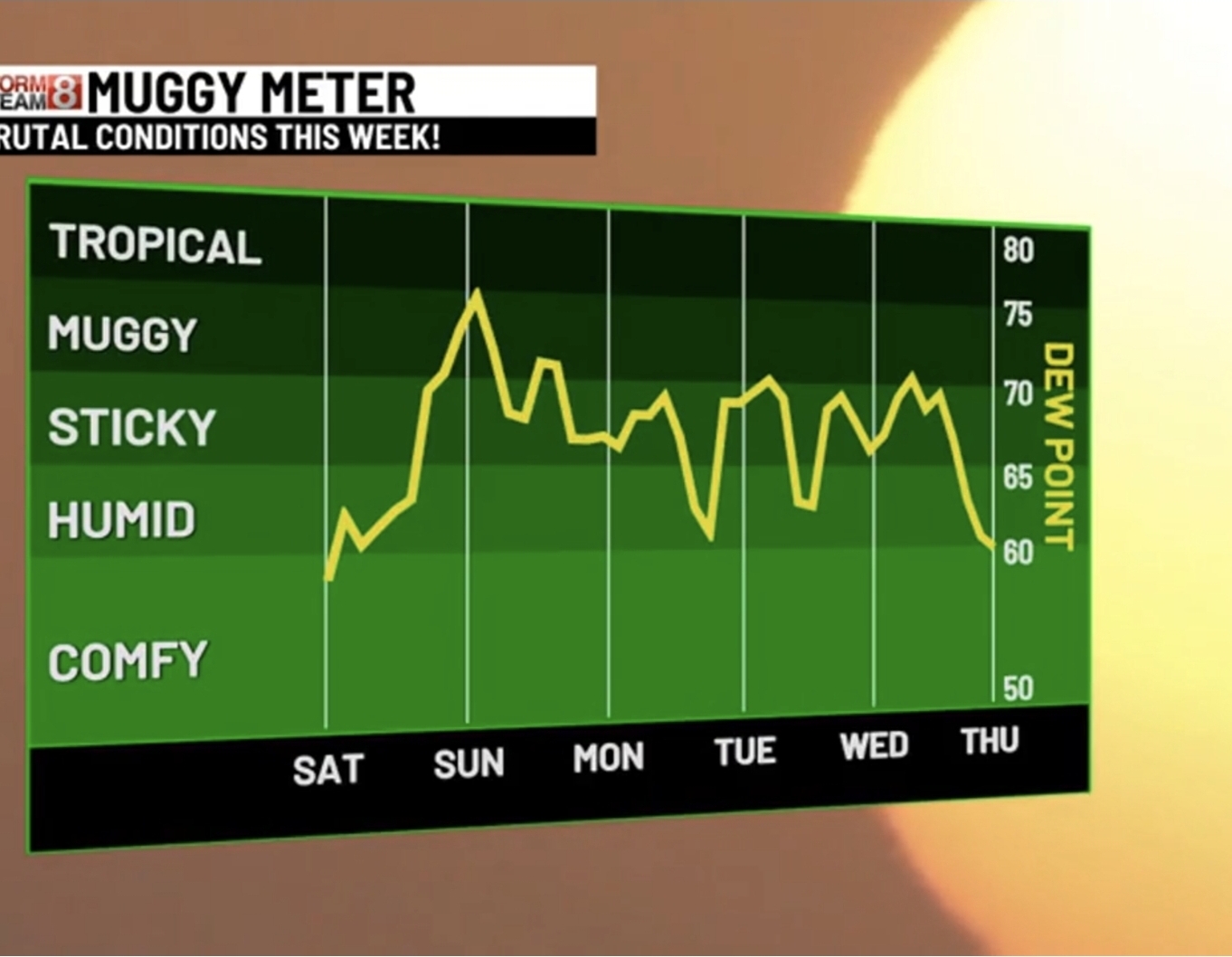
 Great here comes the steam bath. Morning Rain and Humidity.
 -
Looks like we'll bottom out at 80+
-
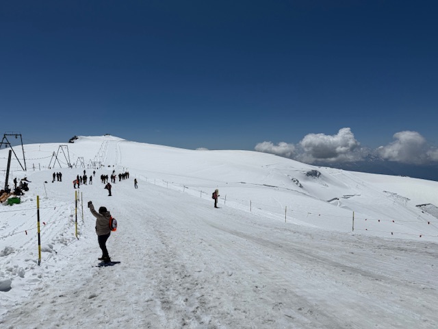
Cooling off in Italy

-
Way less
-
Only 0.11” here. Pretty much done.
-
Upton's thoughts A shortwave pushing through southeastern Canada has forced the development of an MCS that is making its way southeastward through Upstate New York. Despiteits progression toward the area this morning, there remains substantial uncertainty in its ability tomaintain itself as it approaches this morning. The MCS is moving into a less favorable environment and while CAMs disagree as to the exact track and continuance of the MCS, the chance exists for showers and thunderstorms to move into the area this morning.
-
64 degrees this morning, but here comes the sun.
-
Canceling tee time. Stupid crap. Was going to play in belchertown. Looks like they might get 3/4 of an inch. With the lightning around it would back the course way the eff up.
-
-
Hazardous Weather Outlook National Weather Service State College PA 427 AM EDT Sun Jun 22 2025 PAZ036-056-057-059-063>066-230830- Franklin-Perry-Dauphin-Lebanon-Cumberland-Adams-York-Lancaster- 427 AM EDT Sun Jun 22 2025 ...EXTREME HEAT WARNING IN EFFECT FROM 11 AM THIS MORNING TO 8 PM EDT WEDNESDAY... This Hazardous Weather Outlook is for central Pennsylvania. .DAY ONE...Today and tonight. Please listen to NOAA Weather Radio or go to weather.gov/StateCollege on the internet for more information about the following hazards. Extreme Heat Warning. Isolated strong to severe thunderstorms with gusty winds and small hail are possible this afternoon and evening. .DAYS TWO THROUGH SEVEN...Monday through Saturday. Please listen to NOAA Weather Radio or go to weather.gov/StateCollege on the internet for more information about the following hazards. Extreme Heat Warning. A significant and extremely dangerous heat wave will continue through Wednesday. The risk of heat-related illnesses will be elevated given limited acclimation. Heat impacts are likely in some health systems, heat sensitive industries, and infrastructure. .SPOTTER INFORMATION STATEMENT... Spotter activation is not expected at this time.
-
Hope so
-
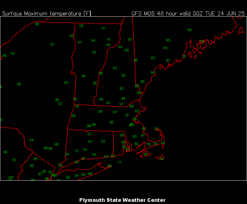
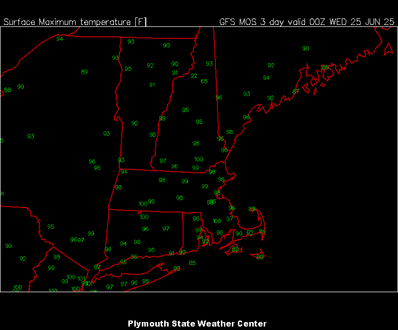
00z MAV for Mon/Tue.
- Today
-
Some activity up there currently.
-
Probably all clear by 10?
-
As suggested by many hear, this thing definitely ended up well west of modeled. Bravo.
-
What a special week coming up.

-
When does it end?
-
Yeah I got a tee time to make.