All Activity
- Past hour
-

July 2025 Obs/Disco ... possible historic month for heat
powderfreak replied to Typhoon Tip's topic in New England
Not going to lie, it does look a lot more refreshing this weekend and next week. There are definitely some gradient days in there for dews, like Sunday, where up north might miss out. But Monday through Thursday of next week looks to offer relief. At least up here, it looks like we see more dews in the 40s and 50s than we do in the 60s for a week starting on Friday. -

July 2025 Obs/Disco ... possible historic month for heat
weatherwiz replied to Typhoon Tip's topic in New England
We get a 2...maybe 3 day break from the dews after the Sunday FROPA but dews crank right back up mid-to-late week ahead of the next front. Of course dews will drop again the next FROPA but its only for another day or 2. The overall theme is high humidity and near oppressive at times. A few day break due to a FROPA doesn't change what the overall theme is. -

July 2025 Discussion-OBS - seasonable summer variability
jm1220 replied to wdrag's topic in New York City Metro
91/76/103. -
It would make sense if this were focused on the last 7-10 years or so....but four decades? the 90s, 00s and 10s were great for NE coastal snowfall. I haven't read it over, but it seems like they are exagerating the sample size to perpetuate a west warm pool derived CC theory because they know there isn't enough data yet.
-

July 2025 Discussion-OBS - seasonable summer variability
SACRUS replied to wdrag's topic in New York City Metro
-
July 2025 Discussion-OBS - seasonable summer variability
SACRUS replied to wdrag's topic in New York City Metro
More clouds now 86 / 73 here -

July 2025 Discussion-OBS - seasonable summer variability
bluewave replied to wdrag's topic in New York City Metro
The bottom line is that the heat stress on the body has been increasing no matter what scale you are using when the dew points and temperatures keep rising. -

July 2025 Obs/Disco ... possible historic month for heat
weathafella replied to Typhoon Tip's topic in New England
ineedtowishawayheat is having a rough summer. -
July 2025 Discussion-OBS - seasonable summer variability
LAVistaNY replied to wdrag's topic in New York City Metro
I pulled 5 dog ticks off my dog after being in the back yard only and found one on a jug of pool chemicals- just crazy for July!!! -
we've been relocated to the equator
-
55 and rain in Rapid city
-

July 2025 Obs/Disco ... possible historic month for heat
Damage In Tolland replied to Typhoon Tip's topic in New England
Incorrect -

July 2025 Obs/Disco ... possible historic month for heat
kdxken replied to Typhoon Tip's topic in New England
Looks like Friday Saturday and then gone again on Sunday. Not much of a stretch. -

July 2025 Discussion-OBS - seasonable summer variability
winterwarlock replied to wdrag's topic in New York City Metro
87/79/101 -
 I mean across all of the other stations in the county
 -
 There are too many missing summer days in a number of recent years, some of which had large numbers of 90° or above days in the region.
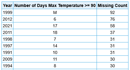
-
It’s mostly cloudy here. Went out to replace a part on my truck at 9 and by 9:20 I was drenched. It gross ass weather like this that made me retire when I did. It just sucks to do anything outside
-

93L – “Inactive” Season Posting Check-In
Kevin Reilly replied to BarryStantonGBP's topic in Tropical Headquarters
Looks like any circulation at all is just SSW of Apalachicola Florida. As stated though not much organization to this as it moves westbound being steered by high pressure to the north and an upper low in the Bay of Campeche. Looks like the most likely situation is a firehose of moisture directed into southeastern Louisiana through much of south central Louisiana. Looking over models over the next two weeks we are in a situation where a stalled out frontal boundary will be sitting near the Northern Gulf Coast and up and down the Southeast United States East Coast which can lead to tropical development in the northern Gulf of Mexico or along the Southeast Coat of the United States then move off to the northwest, north, then northeastward. We will have to watch and see how far north any development off the Southeast Coast can get between now and say July 30th hopefully not to aggravate flooding concerns in North Carolina, Virginia, Maryland, Southeastern Pa, Delaware, and New Jersey. -
Being a surveyor for 30 years I know all too well how bad ticks can be for where they like to hide. I could tell horror stories about ticks. I used to be more afraid of poison ivy than chiggers early on in my career. But as time went on and I got into places with chiggers frequently, I can say now that I would run thru fields of PI happily than get eat up by chiggers. Those damn bugs are the single most useless creature on earth
-
But the rest of the data still clearly shows a lessening of 90 plus days....not surprising in our current warm cycle with higher DPs and mins with lower maxes.
-
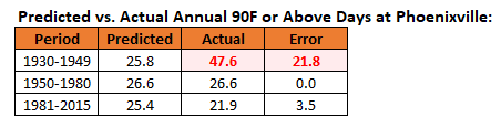
Last year, a similar issue arose regarding 95° or above days at Phoenixville. It's pre-1950 data is unreliable. For the 95° or above highs, I ran regression equations based on the 1950-1980 period testing West Chester and Phoenixville and West Chester and Coatesville. The West Chester - Phoenixville equation broke down badly when applied to the 1930-1949 period, ballooning from 2.8 days to 12.4 days. The West Chester - Coatesville equation held reasonably consistent. This disparity suggested that the issue concerned Phoenixville, not West Chester. To determine whether the 1950-1980 period was an issue, I also tested that equation for 1981-2015 for West Chester - Phoenixville. The equation held up reasonably well. The Coatesville data record ended in 1982, so I could not test the West Chester - Coatesville relationship. The equations for the 1930-1949 and 1950-80 periods strongly argued that Phoenixville's 1930-1949 measurements were at issue and are not reliable. That also includes the currently recognized state maximum temperature record of 111° that was set at Phoenixville. The more likely value is probably near 105° based on the 1950-1980 relationship. I now repeated the exercise for 90° or above highs at Phoenixville. I expected that just as had been the case with 95° or above highs, the 1930-1949 period would see vastly more 90° or above highs than predicted while the 1981-2015 period would not be too different from what was predicted. The outcome: The 1930-1949 Phoenixville data is wildly out of line with both the rest of its historical record and the West Chester data that it is unusable in its raw form for any credible analyses.

-
July 2025 Obs/Disco ... possible historic month for heat
weatherwiz replied to Typhoon Tip's topic in New England
Probably more so the northern half of VT/NH. We may get screwed with s/w subsidence and morning clouds/precip. But up north, closer to the sfc low could be a different game with some better approaching forcing later in the day -

93L – “Inactive” Season Posting Check-In
BarryStantonGBP replied to BarryStantonGBP's topic in Tropical Headquarters
Land killed it -
July 2025 Obs/Disco ... possible historic month for heat
weatherwiz replied to Typhoon Tip's topic in New England
Not sure how much develops tomorrow afternoon, probably going to be quite isolated but I'd watch any storm that develops across upstate NY, VT, and NH. Could be room for a few brief tornadoes there. Large helicity field tomorrow and pretty good CAPE -

July 2025 Discussion-OBS - seasonable summer variability
forkyfork replied to wdrag's topic in New York City Metro
that's because it's full of low info snow voters


