All Activity
- Past hour
-

First Winter Storm to kickoff 2025-26 Winter season
HoarfrostHubb replied to Baroclinic Zone's topic in New England
It’s really nice. -

First Winter Storm to kickoff 2025-26 Winter season
SouthCoastMA replied to Baroclinic Zone's topic in New England
You'll also be rooting for storms that hook in but stay just outside the benchmark. That's our sweet spot -

First Winter Storm to kickoff 2025-26 Winter season
HoarfrostHubb replied to Baroclinic Zone's topic in New England
I doubt anyone gets 10”+. It’s quick moving and you would need really intense rates. -
Not trolling, just a novice observation and welcome any explanations. But I am so tired of seeing the comment about "snowpack being laid down will help us" every single year. Anyone want to elaborate on why snowpack across the mountains and 500 miles northwest will help our battle against a nearly decade long SER problem? Sure it may help with cold-er air chasing our moisture from the southern stream. But I honestly cannot recall a single event where snowpack was featured as the reason our temps were favorable enough to enable a winter storm. What's the thinking here? (And any case studies?)
-

First Winter Storm to kickoff 2025-26 Winter season
CoastalWx replied to Baroclinic Zone's topic in New England
I think you’ll really enjoy that area in the summer. I’ve actually never been to that town specifically, but anywhere along buzzards Bay there is nice. -

First Winter Storm to kickoff 2025-26 Winter season
SouthCoastMA replied to Baroclinic Zone's topic in New England
Where the purple starts on the SE side is where the accumulation begins imo. Don't doubt someone could see 6" within that area though, further inland caveat of euro being correct -
Was confused for a moment because I distinctly remember a December 5th storm which crushed LI, noteworthy for how quickly it melted away. But I see now that one was 2003.
-
Its not just 1 run. The eps has been schooling the gefs
-
In fairness to WNCSNOW, he is as excited as anybody when there is something to be excited about. He doesn't necessarily like to look for the positive when it requires a little searching, but he is quite often right because of that. I don't think he is trolling at all. He is just a realist. Realism can be painful around here though, lol. He is a little negative, but he is a good dude and a good poster to have on this board.
-
First Winter Storm to kickoff 2025-26 Winter season
Kitz Craver replied to Baroclinic Zone's topic in New England
Not too shabby -
-

First Winter Storm to kickoff 2025-26 Winter season
Ginx snewx replied to Baroclinic Zone's topic in New England
-
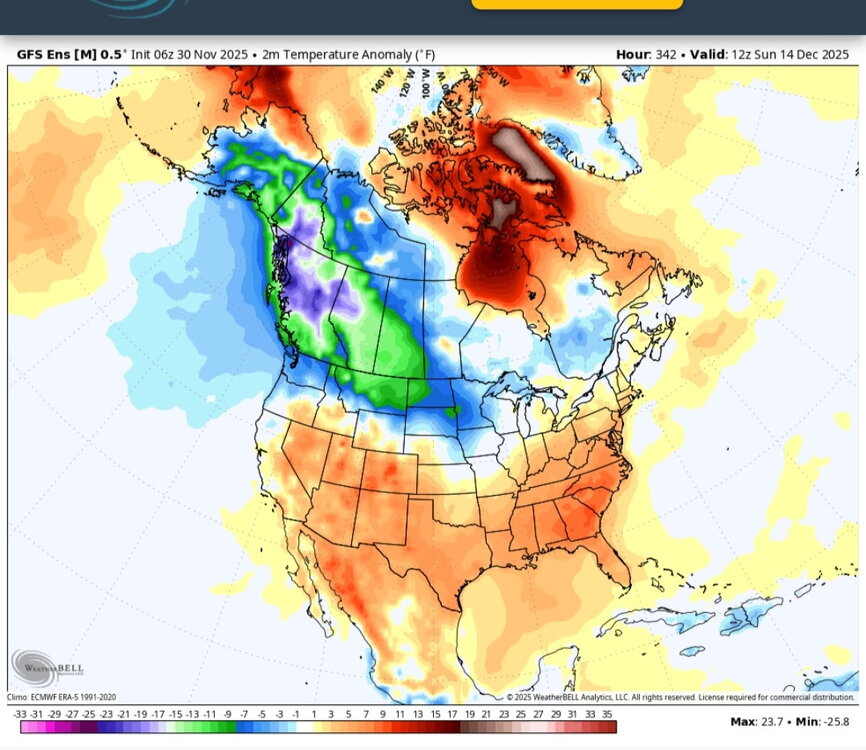
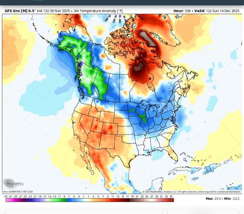
Unfortunately, that’s just one run. But what is persistent is the trough over Alaska. Ideally you would want to see a ridge over Alaska heading into the Arctic which will force the coldest air into CONUS. Mind you, colder than normal temps don’t always equal snow. December 2022 was colder than normal too, and was quite stormy across CONUS with significant snow storms. But for the northeast; it was mainly rain. The month can be cold overall, but when it counts (when there is precipitation nearby, it might be too warm down here for snow.) That being said, the long range looks to be stormy enough across CONUS so hopefully that can coincide with the colder temps and make some snow over here.
-

First Winter Storm to kickoff 2025-26 Winter season
moneypitmike replied to Baroclinic Zone's topic in New England
Yes--SE. I'll be calling for the shuffles in my new spot. They'll happen and I'll still wind up with 1/2 of slush and I'll call it a win. -
I just think it's this cycle we are in. We will break out of it eventually. Just one of those things.
-
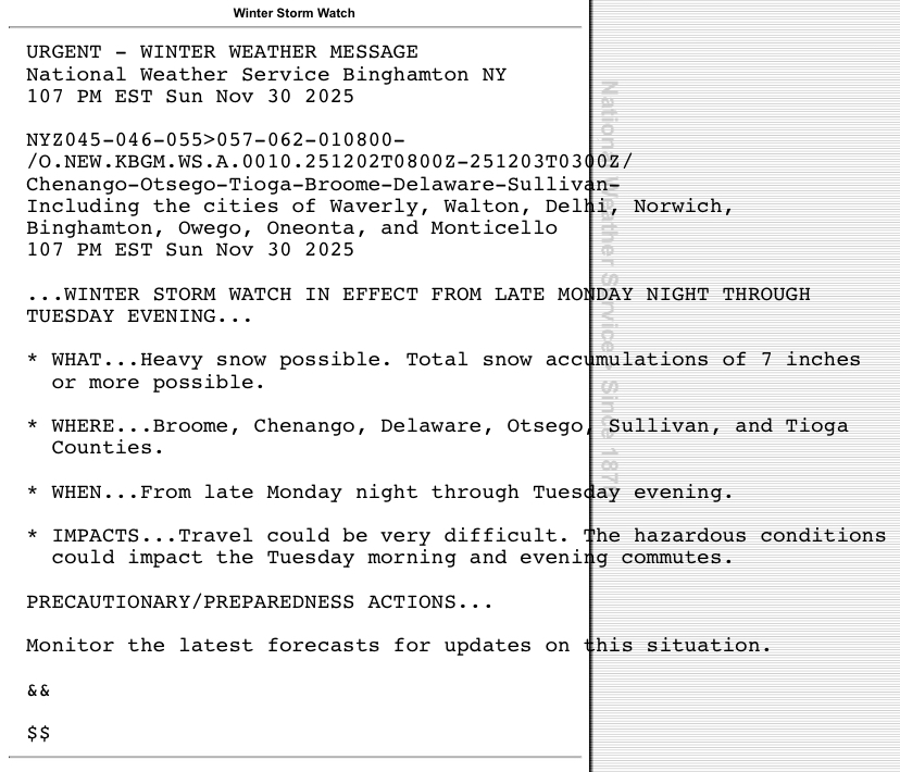
URGENT - WINTER WEATHER MESSAGE National Weather Service New York NY 113 PM EST Sun Nov 30 2025 NYZ067-010700- /O.NEW.KOKX.WS.A.0003.251202T0900Z-251203T0300Z/ Orange- 113 PM EST Sun Nov 30 2025 ...WINTER STORM WATCH IN EFFECT FROM LATE MONDAY NIGHT THROUGH TUESDAY EVENING... * WHAT...Heavy snow possible. Total snow accumulations between 4 and 7 inches possible. * WHERE...Orange County. * WHEN...From late Monday night through Tuesday evening. * IMPACTS...Travel could be very difficult. The hazardous conditions could impact the Tuesday morning and evening commutes. PRECAUTIONARY/PREPAREDNESS ACTIONS... Monitor the latest forecasts for updates on this situation. &&
-

First Winter Storm to kickoff 2025-26 Winter season
CoastalWx replied to Baroclinic Zone's topic in New England
This is kind of where I like the nam when it starts getting into its range it can kind of show that stuff. -

First Winter Storm to kickoff 2025-26 Winter season
SouthCoastMA replied to Baroclinic Zone's topic in New England
yes, a few of those intense Euro runs from 11/28 may have pulled it off even close to the coast. -
-
Low of 38 this morning. High so far of 71 today. After the 2 days with highs in the upper 40's, 71 feels very warm.
-
You think the Euro and EPS data isn't useful when its the model with the best verification scores?
-

First Winter Storm to kickoff 2025-26 Winter season
CoastalWx replied to Baroclinic Zone's topic in New England
Lower confidence there. I tend to agree. Can always hoist early tomorrow. -
The asinine nature of your posts is what is trolling. But you know that. Anyway, I’ll patiently wait for the others with actual useful information to post now. Have fun being miserable.


.png.9fa7eed9a689ddb9d385baf7ef967901.png)


