All Activity
- Past hour
-

January 24-26: Miracle or Mirage JV/Banter Thread!
Paleocene replied to SnowenOutThere's topic in Mid Atlantic
So, summary of 12-18z is "rain in Georgetown?" -

“Cory’s in LA! Let’s MECS!” Jan. 24-26 Disco
HoarfrostHubb replied to TheSnowman's topic in New England
Thanks for offering a forecast (looks decent)…unlike some other residents of Weymouth -
Just saw his map
-

“Cory’s in LA! Let’s MECS!” Jan. 24-26 Disco
MaineJayhawk replied to TheSnowman's topic in New England
You Love To … -
Wildre back?
-

Possible Record Breaking Cold + Snow Sunday 1/25 - Tuesday 1/27
SnoSki14 replied to TriPol's topic in New York City Metro
I'm going with the wall of snow to sleet idea. We could easily accumulate 6-8+" over a few hours if it comes in fast and heavy. Heavy snowfall rates could also help keep mid levels colder so we hold onto snow longer until things lighten up enough where we fully go to sleet -
 To sleet? it's happened a lot I think, rain almost never. I guess it also depends what you define near the coast, for example March 2017 in lower Westchester was snow to sleet to snow with almost a foot of snow and lots of sleet. Honestly now that i think of it it's happened many times even in the city I just can't remember exact dates, snowicane was another example that comes to mind with 12+ despite different precip types.
 -
If it keeps going anymore north for the next few runs then it’ll be nothing, but cold rain here. I’ve given up on seeing any snow, and am just rooting to avoid the icy mix slop.
-
A 1025 high on top of us at 93 keeps us good and good for preceding hours but the 99 you posted has a 1012 on us and that would not be all snow for DC
-
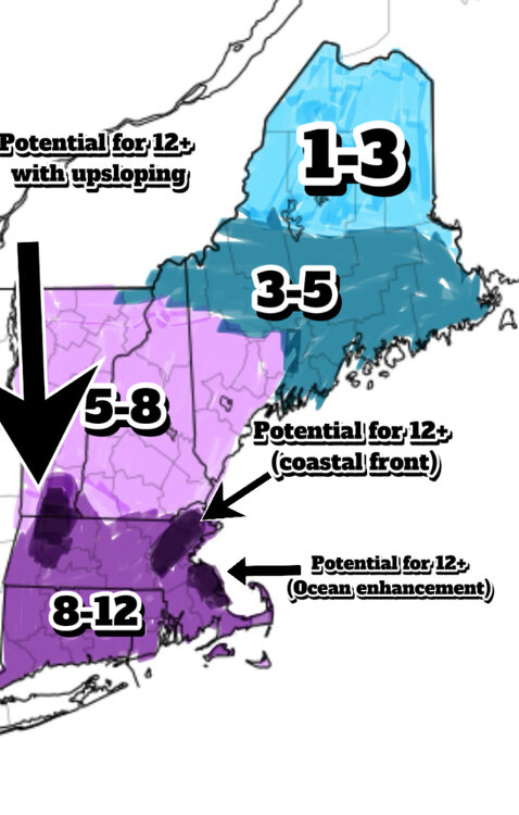
Lil early to make a snow map but I guess why not
-

January 24-26: Miracle or Mirage JV/Banter Thread!
winter_warlock replied to SnowenOutThere's topic in Mid Atlantic
U did fine bro!!! U can't control SV jumping the way it does -
It's got to be the confluence. If the high is further north and further east that lets the primary come up further north and further west. So, like someone said, I don't know that the Baja low sampling is going to give us much - we really need that energy in Canada to be sampled to figure out what's going to happen.
-

“Cory’s in LA! Let’s MECS!” Jan. 24-26 Disco
40/70 Benchmark replied to TheSnowman's topic in New England
? -
No doubt ! Temps into the lower to mid 30’s. lol I hate this hobby. J/k .
-
I believe that there is some validity to this but how much...??? That's a lot of energy being transferred down to the earth during that storm.
-
It keeps flirting with all-time record lows. Getting any models to show -20s in this area is remarkable.
-
I heard him say slight chance of rain snow showers.
-
 this post was barely literate. As others have said you need to watch for the mid level warming here based on placememt of 850 low. Valentine's Day 2007 temp never got above 25 and it was a sleet fest. I don't think that will happen here, but it isn't as simple as a storm plowing into cold air. and I think that EDuggs posts are good--certainly better than yours.
 -

January 24-26: Miracle or Mirage JV/Banter Thread!
stormtracker replied to SnowenOutThere's topic in Mid Atlantic
My bad on the sloppy pbp. I was cooking (shrimp fetuccini alredo!) AND screenshooting. Panels were in that order because I'm dead serious. SV will jump from like 81 to 105 with zero panels in between and start filling in while still advancing. I like the fast output but they could at least fix the algorithm to make it pop in in order -

Possible Record Breaking Cold + Snow Sunday 1/25 - Tuesday 1/27
Prue11 replied to TriPol's topic in New York City Metro
Yea Juno was 2015 -
Thats actually... not that bad! I'll take it. Is it just American models that get recon data, or do Euro, UK, Canadian, etc., get it?
-

“Cory’s in LA! Let’s MECS!” Jan. 24-26 Disco
WxWatcher007 replied to TheSnowman's topic in New England
By the time you mix, if you did, you'd be sitting on a foot of powder at least. Your pack would be bulletproof in the cold that comes after... -
Gonna be some nice polar cold here for sure but we’d probably really bottom out if the snowpack was deeper. ~4” otg imby
-
Thanks for this, friend. I’m expecting sleet at some point, given the map Snowden just shared above. While I have the latitude and elevation, I have found being on the eastern side of Parrs Ridge, I get sleet more often than not. However, I will also get the higher ratio snow in the WAA part, so it balances out.
-
January 24-26: Miracle or Mirage JV/Banter Thread!
winter_warlock replied to SnowenOutThere's topic in Mid Atlantic
Way I see it.. I prefer snow .. but...sleet is better then rain!!