All Activity
- Past hour
-
App has about a half inch in total .
-
Frost tonight and 90 by Sunday. The bimodal distribution continues
-
Whatever your app has
-
What's your forecast?
-
I’m assuming you’re as uninformed as most of your tweet and wx app posts and missed the Euro part
-
Looking to get cold up your way tonight and tomorrow night. Stick with the couch.
-
Killer sunset out there
- Yesterday
-
Accordion man won’t like that map
-
Yeah, Eastern Mass barely gets over 4"

-
Incorrect . It’s mainly over Friday in SNE other than a shower
-
Multiple pics of a big waterspout between Morehead city and harkers island
-
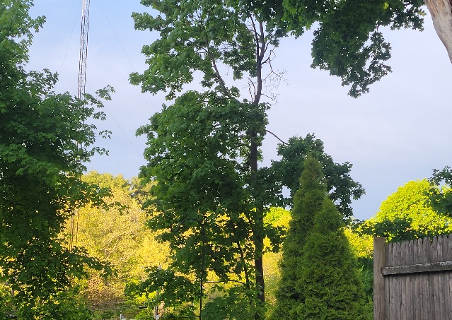
Not a big fan of spring but damn if it can't be pretty. Something about the new leaves and lighting.
-
Yeah its thu night-Friday. Euro has 2-5"
-

E PA/NJ/DE Spring 2026 Obs/Discussion
RedSky replied to PhiEaglesfan712's topic in Philadelphia Region
Slight chance of frost -
Storms missed me by about 5 miles. Only got .03" today. Big cool down though. Went from 82 to 66 in a matter of a few hours.
-
Euro only has .25-.30 river East for Thursday . Congrats west of River . Stein east
-
Wheel of rhea Thursday and Friday eh?
-
The whole 2m philosophy needs a make-over. It's abysmal. That over mixing thing is a separate error to the under-sold high temps that happen in the actual heat wave. It's like errors in both directions are true. weird. It seems... beyond the late short range the model mixing is over proficient... but as it comes into shorter vision, the model corrects but then it just assigns the sfc sigma as 1000 mb level and calls that the 2m. There's a new error anyway, world over, having to do with this new phenomenon surrounding 'synergistic heat waves' - they exceed everything. We've talked about this in the past... There's been several between Iberian Penn as far N as London. Australia. Siberia... the steppe country near the Urals over the hills into Moscow. The Pacific NW... "sort of" 2012 in the lower OV - it tried to get in here but was cut off by a corrective derecho that pretty much undermind the ridge for everyone. These are a different thing altogether where nothing gets them right because they are literally synergistically created - like emergent properties where the temp just runs away beyond all convection means of forecasting, machine to man. I don't think there was very many this last year but it was a reasonably well-coupled cool ENSO mode so that maybe has some capping aspect. But oh gee, guess what ...we're heading into super dong.
-
Surprised how widespread the frost was this morning. Drought concerns starting to creep into this area if we don’t get some rain soon.
-
If it is not 1/4SM VV001 +SNFZFG, Scott be like "MEH!"
-
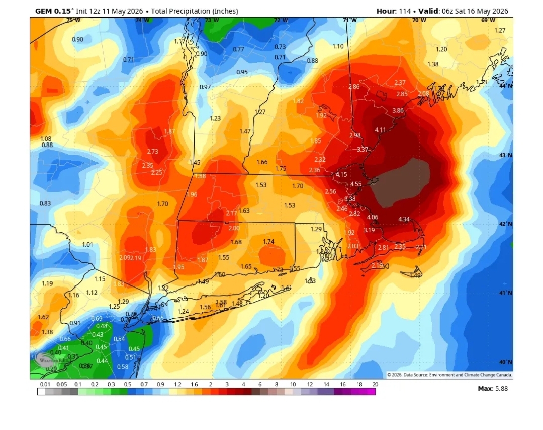
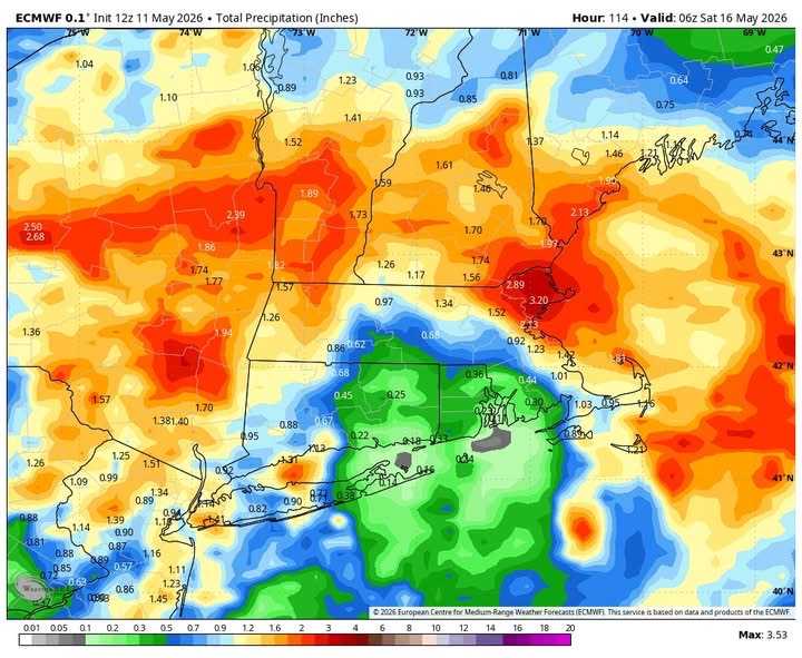
"Worse after brief improvement" from the article. Yes, slight up and downs week-to-week. Why is this news? It is always oscillating like this. How is that any different than when it is wet and then "less wet" for a period? Taking about it constantly does not make it physically any worse of better, but they don't care. Anything to hype the negative. Today is the 12th day in a row w/ measurable precip in New England. 12z ECMWF now showing up to 3.5" for the upcoming slow-moving storm. All other global models show widespread 1-2" across the region. The point is taking snapshot week-to-week is excessive in this case. It's not like w/ are baking day after day w/ full sun and high evaporation rates.
-
0.36" today. Most rain in one "event" since probably March. Chilly out there. Feels like a late October day. 52 I can see the clearing line to the west, so might get a bit of sun to end the day.
-
Looks like the wonderful dry weather is back. No rain in sight for the next couple of weeks, add some 90's to that too.
-
I still think you should be more than happy Weymouth got two 20"+ "white gold" events in one season this past winter. I bet that has not happened more than 10x in last 60-70 years in the immediate area. Let me put it this way, nothing even remotely close like this happened in the 80s. Scott used to get mad as a kid when he expected 4-8" fcst by WBZ on the "backlash" and he'd wake up next morning to sunny conditions! "I WANTED NO 'SKEWL' !!!" I had my share. I recall on NOAA Wx Radio, NWS BOS would say "the storm failed to develop." This was a fcst like 24 hr out. Storms don't just "fail" like that in such short range. It was the stupid LFM model turning flat waves into 980 mb S+ events! It had so many problems w/ convective feedback. The NGM out by 1985 largely took care of his problem, but Scott still called it the "NO GOOD MODEL!"
-
We got about .2 here. About 15 miles south of me there was around 1/2 inch.


.thumb.gif.f92b16c631a1d15d405ed77b33f0710d.gif)