All Activity
- Past hour
-
I think it was Spring '22 that had a few of those hail/snow showers through April here.
-

It's time to grade Winter 2025-26(now that it's actually over)
SnowenOutThere replied to CAPE's topic in Mid Atlantic
Man I've wanted to make a breakdown post of my thoughts on this winter but I'm not sure I'll ever get around to it. I'm torn between giving this winter a harsh C- grade based on missing three HECS - one of which should've been a slam dunk to the point we had to be unlucky to miss - and the fact that the snowcrete sucked ass for all the activities I enjoy doing outside. I could characterize this winter as one that fell short in nearly every event outside of the December ones. On the other hand, this winter could be an A grade. We had 2 early December snowfalls! I went out to WV for a good snowstorm the 10th of November, and then again for two beautiful hikes in early January. The Jan 25th storm was a very cool experience - though flawed - it is one I will remember. Then we got a surprise snow burst at UVA in Feb (and one later in March with flowers out which was amazing). I got to travel up to NOVA for the missed late Feb HECS and got to enjoy a period of really heavy snow. I really think how you grade this winter comes down to what you value and what you're able to put aside. If you put aside the what ifs? Or the expectations of what it could've been - or should've been in case of Jan 25th - you get a winter that was extremely memorable, cold, had plenty of decent snow events (and some fun surprise ones!). Yet, I don't think its entirely fair to isolate it from that expectation. We rarely get chances like this winter and they did fall short. We did miss a HECS because literally everything that could go wrong from five days out did go wrong! We missed two more in less abnormal or rare ways, but we still did ultimately barely miss them. On a personal note, it is also the winter where I first really understood the mechanics of synoptics for the first time. This was both a blessing and a curse. It's amazing to be able to talk with some of the posters I've looked up to for years on some, though of course unequal, level. It's so cool to see how the jet interacts with synoptics to produce lift and cyclogenesis. It is an amazing feeling to be able to forecast based not off any surface map and then get it right and watch it snow (see the December storms)! It, however, also means it sucks to watch a setup that should, and was so close to, producing big simply fail to come together right. There is an acute awareness of exactly what went wrong (850 low in Ohio valley) and what is it doing, but you are just a spectator. Its a weird dynamic and one I need to learn better (probably involves only allowing myself to read models/post between 1pm and 7pm or something). Since I probably won't get around to a storm by storm breakdown I'll give my final grade here: B+. I can't quite go higher considering the snowcrete really messed up my ability to do anything fun outside for a month, alongside the mentioned close calls; but, going any lower is disrespecting what this winter actually was. Finally, I have kept an achieve of google docs with all my synoptic breakdowns throughout the winter. If anyone has interest in revisiting them/the storms let me know and I can clean them up and make a post with the links. -
Well the exaggeration can be quite much at times.
-
GFS and to a lesser extent the CMC shunts it all to our SW via a blocking high over SE Canada. Still 5-6 days away
-

E PA/NJ/DE Spring 2026 Obs/Discussion
PhiEaglesfan712 replied to PhiEaglesfan712's topic in Philadelphia Region
The ground is too warm, and the sun angle is way too high, for that. Keep in mind, the latest snowstorm in Philadelphia was on April 19-20, in 1983. If there was heavy sleet right now (which there isn't), it would be historic. -
It is 4/20
-
Speak for yourself. I'm up past 60 degrees at UVA. Beautiful spring day with a nice breeze.
-
Is that full leaf out? I was told that would be happening by today
-

E PA/NJ/DE Spring 2026 Obs/Discussion
Chadzachadam replied to PhiEaglesfan712's topic in Philadelphia Region
heavy sleet in NW Philly (: -
You can just keep that stuff to yourself thank you very much.
-
I'm impressed with this airmass. It's late April and I'm only at 50° as we approach noon.
-
if you turn your phone sideways you can see locations.
-
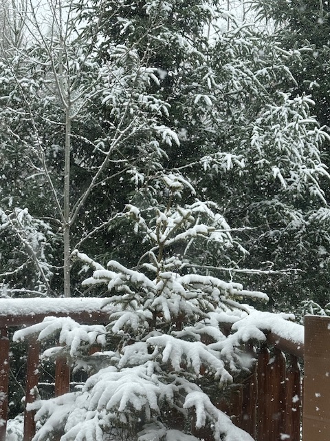
and now it’s snowing here.
-
Thanks I was wondering about this. Hoping that this is our last Freeze up here. Getting a new HVAC system put in tomorrow. After the morning the day looks good for not having any heat or air con for the day.
-
Graupel downpour missed me just to the east in Herndon. 50/31 at IAD currently.
- Today
-
I would be thrilled but not this weekend. Have my son's baptism on Saturday.
- 721 replies
-
- 1
-

-
- april showers bring may..
- rain
- (and 2 more)
-
If it actually does bring rain I’d be thrilled. If it’s just raw drizzle that does diddly squat to moisten the soil and just makes it miserable, it’s par for the course.
-
Yay east winds and rain this upcoming weekend
- 721 replies
-
- 1
-

-
- april showers bring may..
- rain
- (and 2 more)
-
(002).thumb.png.6e3d9d46bca5fe41aab7a74871dd8af8.png)
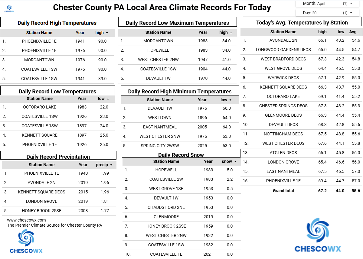
Central PA Spring 2026 Discussion/Obs Thread
ChescoWx replied to Voyager's topic in Upstate New York/Pennsylvania
A Freeze Warning is in effect tonight through 9am tomorrow morning. Be sure to protect any tender plants by late tonight. In my 22 years here the average date of my last freeze has been April 10th. Valley locations across the area have averaged later last freeze dates. High temperatures today will be almost 20 degrees below normal temperatures in the 40's. We start a warming trend through the rest of the work week before chilling down and turning wet for the weekend.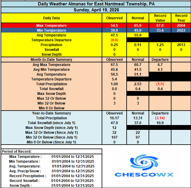
-
E PA/NJ/DE Spring 2026 Obs/Discussion
ChescoWx replied to PhiEaglesfan712's topic in Philadelphia Region
A Freeze Warning is in effect tonight through 9am tomorrow morning. Be sure to protect any tender plants by late tonight. In my 22 years here the average date of my last freeze has been April 10th. Valley locations across the area have averaged later last freeze dates. High temperatures today will be almost 20 degrees below normal temperatures in the 40's. We start a warming trend through the rest of the work week before chilling down and turning wet for the weekend.
-
This is ridiculous
-
Definitely bimodal lol Why is it so hard to just do a climo spring day in the upper 60’s
-
Just light sprinkles in Fairfax City. I can't see locations on mobile; I assume it's only the high mountains that are getting actual snow.
-
Same here, we undershot forecasts by 5-7 degrees and a lot of places reported frost
-
What a crap day. Feels weird being this bright out with the sun angle, but so cold.