All Activity
- Past hour
-
agreed for there...was mostly focusing 84 corridor. But we'll see what happens...if we can get a track like the NAM, even slight west then more of the region may end up dry slotting and the afternoon could end up decent.
-
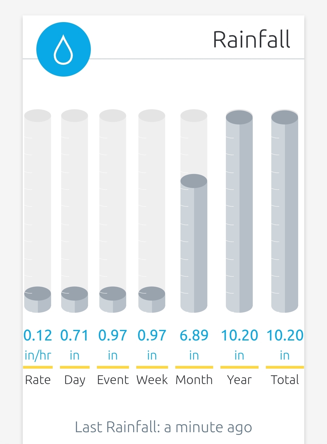
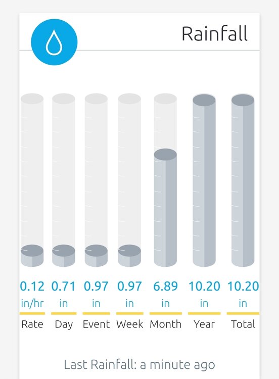
55 degrees and only .12” of rain. Slow and steady today I guess. Mow # 10 in yesterday.
-
I see 65-70 or a bit higher with dews I-95 east.
-
I didn't ask about the specifics regarding how to determine if there are biases, errors, or mistakes in a temperature record. I asked why we should knowingly keep biases, errors, and mistakes in a temperature record and why we should not digitize and upload old station observations.
-
 Typically the low will occur just before sunrise and the high will occur in the afternoon. Weather conditions of course change this up but to simplify it if you were to have for example 83/62 as your forecasted high and low. The high will occur around 2-5pm (depending on the season) and the low will usually occur 3am-6am. The low temp is usually going into not coming from. So if you happen to have a low of 58 in the morning when hitting that 83 forecast that same day the low going forward is forecast to be 62 for the next morning. So the day before the forecast would have maybe looked like 78/58 going into the 83/62. When the low or high hits it may just be for a brief moment and not a multi hour situation. Hope this helps.
 -
eh I mean upper 50's to lower 60's with thick overcast for May 31 flat out sucks lol...especially for a weekend. Could be quite breezy too far SE areas with the LLJ passing overhead. But I guess that is better than upper 40s/lower 50's and a heavy rain
-
Might include you. This time of year east of the low track probably isn't bad. Maybe a few showers to dodge near you? Cutting it close there.
-
WB is honking that the AMO is continuing to show signs of flipping. Will be interesting to see what this does to global temps and our winters once it finally happens. Should be good for snow.
-
By Southeast do you mean from you to the cape? Please include me. Thanks in advance.
-
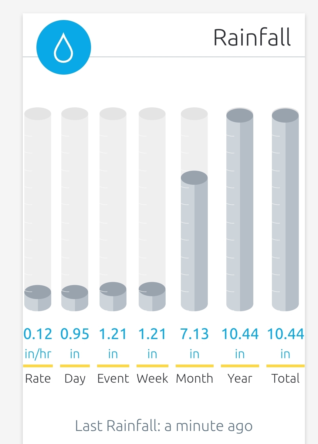
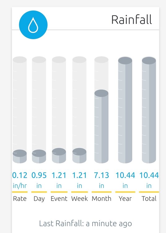
Pretty impressive after the slow start yesterday. It's insane that nearly 70% of my year to date total has fallen in May
-
West and north is worst Saturday. Looks ok for SE areas.
-
You might have to bring back that lush, green pic you had a few years ago
-
If only 5 months ago.
-
I was aware of FedEx planes over the years. It wasn't until one of my ones began working for a major passenger airline on the cargo side did I learn about the cargo that goes on passenger planes as well.
-
another classic cool rainy day, no big totals here this month but the cool temps and long duration events have kept things green despite the long term deficits creeping up
-
Bring on that much needed heat we been missing and those sultry dewpoints as well.
-
THIS. It has been quite awhile since we have had a good region-wide soaking rain over a long period of hours. Really, REALLY welcome.
-
2025-2026 ENSO
so_whats_happening replied to 40/70 Benchmark's topic in Weather Forecasting and Discussion
While oceanic temps have definitely increased probably the most drastic of changes has been in the Arctic over the last 50 years I feel this probably is the biggest reason we have been having issues with pattern semblance over the last decade or two, more notably. It may very well be the reason for such changes to the PDO state but im not ready to make those accusations or conclusions. Over the last 5 years the Antarctic has suffered rather drastic changes to the ice sheet I wonder if we start seeing similar results within the southern hemisphere as we have seen in the northern with the idea of permanence taking shape. -
0.85" currently. Very nice regionwide rainfall.
-
what a beautiful, clean phase too...can't buy those in winter
-
2025-2026 ENSO
so_whats_happening replied to 40/70 Benchmark's topic in Weather Forecasting and Discussion
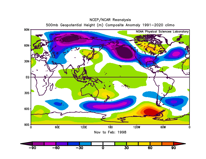
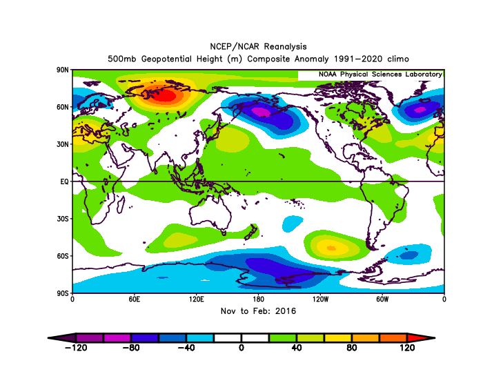
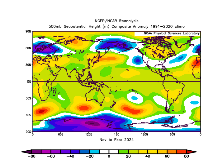
RONI peaked in 2015/16 NDJ of 2.38. ONI of ~2.6 RONI peaked in 1997/98 SON also at 2.38. ONI of ~2.4 https://www.cpc.ncep.noaa.gov/data/indices/RONI.ascii.txt Im personally still not on the RONI bandwagon as being a reasonable indicator of what will occur but to each their own. This type of atmospheric pattern in 2023/24 was closer to the strong/super Ninos even with the RONI showing barely strong status. I included 1972/73 as that was the last deeply -PDO/ +ENSO we experienced of course it is apples to oranges as nearly 50 years of oceanic warming have changed things up a bit.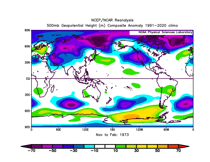
-
But there is a risk for a rogue strong storm or two
-
It is not that simple. Cargo is big money. JFK has the highest value of cargo shipments in the US. Fed Ex has a major hub at EWR. Cargo is very important to the functions of airports. The immediate acute problem at EWR is one of the two main runways being closed. That will end in mid June. The other lingering problems include moving a bunch of disgruntled union employees from Westbury to Philly because they could not longer staff the Tracon on Long Island due to high costs and old housing stock. That will payoff long term as newer employees are more willing to live in the suburbs of Eastern Pennsylvania with its low taxes and cheaper/newer houses and they can actually FULLY staff the Tracon. The other long term problem is fully modernizing the ATC system. That needs funding and attention
-
Saturday looks horrid
-
1.06 and still counting